
Nellore district, officially known as Sri Potti Sriramulu Nellore district or simply SPSR Nellore district in Coastal Andhra Region, is one of the 26 districts in the Indian state of Andhra Pradesh. According to the 2011 Census, the district's population was 2,469,712 of which 29.07% was urban. Its administrative headquarters are located in Nellore city. Located in the Coastal Andhra region, the district is bordered by the Bay of Bengal to the east, Kadapa district and Annamayya district to the west, Prakasam district to the north, and Tirupati district to the south. Map

Nuzvid is a city in Eluru district of the Indian state of Andhra Pradesh. It serves as the administrative headquarters for Nuzvid mandal and Nuzvid revenue division.
Kandukur or Kandukuru is a town in SPSR Nellore district of the Indian state of Andhra Pradesh. It is a municipality and the headquarters of Kandukur mandal as well as Kandukur revenue division. Kandukur Mandal is located at the south-east side of the Prakasam District having geographical area around 225 sq km.There is only 1 city in the Kandukur Mandal, which is Kandukur Municipality having an area of 37.63 sq km.

Repalle is a town in Bapatla district of the Indian state of Andhra Pradesh. The town is one of the 12 municipalities in Bapatla district and the headquarters of Repalle mandal under the administration of Bapatla revenue division. It is situated near Krishna River in the Coastal Andhra region of the state.
Singarayakonda is a town in Prakasam district of the Indian state of Andhra Pradesh. It is the mandal headquarters of Singarayakonda mandal. Singarayakonda is located at sea level. It is spread across 10 Grama panchayats. It is under Kandukur Revenue division. Singarayakonda is located 30 kilometers from Ongole. This is situated on the NH-5 Highway and has a connectivity of the Railway line between Vijayawada and Chennai. This gives highest revenue than any other station in this line of South Central Railway in the Prakasam district. This also has been the center for transportation for all the nearby villages which are located around a distance of the 15 kilometres (9.3 mi) from this place.
Kankipadu is a suburb of Vijayawada and a in Krishna District of the Indian state of Andhra Pradesh. It is also the mandal headquarters of Kankipadu mandal in Vuyyuru revenue division.
Challapalli is a village in the Krishna district of the Indian state of Andhra Pradesh. It is located in the Challapalli mandal, Machilipatnam revenue division.
Giddaluru is a town in the Prakasam district of the Indian state of Andhra Pradesh. It is the mandal headquarters of the Giddaluru mandal in Markapur revenue division. It was part of kurnool district till 1969 later it was merged into Prakasam district in 1970. Till 2008 it was under Nandyal parliament segment after delimitation it was moved to Ongole MP segment. Giddalur is also known as "3 zilla la muddu bidda " because during the Britishers rule it was in kadapa district later moved to kurnool then in 1970 merged in prakasam district. Giddalur is the only constituency in coastal districts which has Rayalseema culture,slang and traditions. Giddalur town has good transport connectivity to Nandyal, Markapur, Podili, Ongole, Kurnool, Kadapa.
Karlapalem is a village in Bapatla district of the Indian state of Andhra Pradesh. It is the headquarters of Karlapalem mandal in Tenali revenue division.
Kollur is a village in Bapatla district in the Indian state of Andhra Pradesh. It is the headquarters of Kollur mandal in Repalle revenue division.
Martur is a mandal panchayat in Bapatla district of the Indian state of Andhra Pradesh. It is the mandal headquarters of Martur mandal in chirala revenue division. As of 2011 Census of India, Martur had a population of 21,434 with average literacy rate of 67.48 %. Martur is famous for granite polishing industries and Vegetable market.

Parchur or Parchuru is a town and an Assembly constituency in Bapatla district of Andhra Pradesh, India. It is also the mandal headquarters of Parchur mandal in chirala revenue division.

Buddam is a village in Guntur district of the Indian state of Andhra Pradesh. It is located in Karlapalem mandal of Tenali revenue division.
Thallada (Thiladri) is a mandal in Khammam district of Telangana, India.
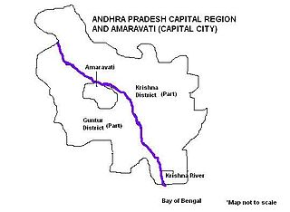
Andhra Pradesh Capital Region is the metropolitan area of the defacto capital city Amaravati of Andhra Pradesh in India. The region is spread across the districts of NTR, Krishna, Guntur, Palnadu, Bapatla and Eluru. It includes the major ancient cities of Vijayawada, Guntur and Tenali. Vijayawada is the largest city and headquarters of the region. It is one the most populated metropolitan area in Andhra Pradesh and eight largest in India, with its suburbs Vijayawada, Guntur, and Tenali being the 3rd, 24th, 41st most densely populated cities in the world respectively. Vijayawada is the most densely populated city in India while Guntur is 11th and Tenali is the most populous city of 14th place in Andhra Pradesh. The region is under the jurisdiction of Andhra Pradesh Capital Region Development Authority and covers an area of 8,603 km2 (3,322 sq mi) under 58 mandals . The defacto capital city Amaravati is an urban notified area and will cover 217.23 km2 (83.87 sq mi), within the Andhra Pradesh Capital Region.

Ongole revenue division is an administrative division in the Prakasam district of the Indian state of Andhra Pradesh. It is one of the 3 revenue divisions in the district which consists of 12 mandals under its administration. Ongole is the administrative headquarters of the division.
Markapur revenue division is an administrative division in the Prakasam district of the Indian state of Andhra Pradesh. It is one of the 3 revenue divisions in the district which consists of 13 mandals under its administration. Markapur is the administrative headquarters of the division.
Mahabubabad district is a district in the Indian state of Telangana. The district was carved out from the erstwhile Warangal district following the re-organisation of districts in the state in October 2016. The district shares boundaries with Suryapet, Khammam, Bhadradri, Warangal, Mulugu and Jangaon districts.

Palnadu district is a district in coastal Andhra Region in the Indian state of Andhra Pradesh. With Narasaraopet as its administrative headquarters, it was formed on 4 April 2022 to become one of the resultant twenty-six districts The district was formed from Gurazala, Sattenapalli and Narasaraopet revenue divisions from Guntur district. The district covers most of the Palnadu region. Map

