Related Research Articles

Meghalaya is a state in northeast India. Meghalaya was formed on 21 January 1972 by carving out two districts from the state of Assam: (a) the United Khasi Hills and Jaintia Hills and (b) the Garo Hills. The population of Meghalaya as of 2014 is estimated to be 3,211,474. Meghalaya covers an area of approximately 22,429 square kilometres, with a length-to-breadth ratio of about 3:1.
Mawsynram is a town in the East Khasi Hills district of Meghalaya state in Northeastern India, 69 kilometres from Shillong, the state capital. Mawsynram receives the highest rainfall in India. It is reportedly the wettest place on Earth, with an average annual rainfall of 11,872 millimetres (467.4 in), According to the Guinness Book of World Records, Mawsynram received 26,000 millimetres (1,000 in) of rainfall in 1985. Mawsynram received 745.2 mm of rainfall on 19 August 2015, probably the highest rainfall received by the town in recent times. On 17 June 2022, Mawsynram set a new record by receiving 1003.6 mm in a span of 24 hours which has now become its highest single day record for the month of June and for its all time single day record beating its former record of 944.7 mm on 7 June 1966.

East Khasi Hills is an administrative district in the state of Meghalaya in India. The district headquarters are located at Shillong. The district occupies an area of 2752 km² and has a population of 825,922. As of 2011, it is the most populous district of Meghalaya's 12 districts.
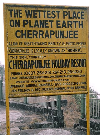
Cherrapunji or Sohra is a sub-divisional town East Khasi Hills district in the Indian state of Meghalaya. It was the traditional capital of ka hima Sohra.

Agumbe is a village situated in the Thirthahalli taluka of Shivamogga district, Karnataka, India. It is nestled in the thickly forested Malenadu region of the Western Ghats mountain range. Owing to its high rainfall, it has received the epithet of "The Cherrapunji of South India", after Cherrapunji, one of the rainiest places in India.


Coimbatore district is one of the 38 districts in the state of Tamil Nadu in India. Coimbatore is the administrative headquarters of the district. It is one of the most industrialized districts and a major textile, industrial, commercial, educational, information technology, healthcare and manufacturing hub of Tamil Nadu. The region is bounded by Tiruppur district in the east, Nilgiris district in the north, Erode district in the northeast, Palakkad district, Idukki district and small parts of Thrissur district and Ernakulam district of neighboring state of Kerala in the west and south respectively. As of 2011, Coimbatore district had a population of 3,458,045 with a sex ratio of 1,000 and literacy rate of 84%.

Periyakulam is a major town and a municipality in Theni district, in the Madurai Region, South Indian state of Tamil Nadu. As of 2011, the town had a population of 42,976. Periyakulam is the northern gateway of the district.

Valparai is a Taluk and hill station in the Coimbatore district of Tamil Nadu, India. It consists of Anamalai Tiger Reserve. It is located 3,474 feet (1,059 m) above sea level on the Anaimalai Hills range of the Western Ghats. There are a total of 56 estates here. The game of football is very popular here. State level competitions are held every year. The foothill starts exactly from Monkey Falls which is at a distance of 38 kilometres (24 mi) to Valparai. The route to Valparai from the foothills consists of 40 hairpin bends. The Kerala state border town of Malakkappara is at a distance of 27 kilometres from Valparai. While major portions of the land are owned by private tea companies, large forest areas continue to be out of bounds.
Athirappilly is a first grade Grama Panchayath with 489.00 km2 area in Chalakudy Taluk, Thrissur district in Kerala, India. It is located 60 km from Thrissur city, 70 km northeast of Kochi city, 55 km northeast of Cochin International Airport, and 30 km from Chalakudy town.

Lloró is a municipality and town in the Chocó Department, Colombia. It claims the second world record for highest average annual precipitation with 12,717 mm (501 in), after López de Micay, which holds an also disputed record with 12,892.4 mm (508 in). The official record is held by Mawsynram, India. The rainfall data was measured in its Agricultural Farm, managed by the University of Bogotá, between 1952 and 1989. If accurate, that would make it the wettest place in the world. The town is named for Gioró, a pre-Columbian indigenous chief.

Nohkalikai Falls is the tallest plunge waterfall in India. Its height is 340 metres (1,115 ft). The waterfall is located in the Indian state of Meghalaya, near Cherapunji, one of the wettest places on Earth. Nohkalikai Falls are fed by the rainwater collected on the summit of a comparatively small plateau and decrease in power during the dry season, from December to February. Below the falls is a plunge pool with water of an unusual shade of green.

Monkey Falls are natural waterfalls located near the uphill ghat road Valparai on the Pollachi-Valparai road in the Anaimalai Hills range, in Coimbatore district.

State Highway 21 or Chalakkudy-Malakkappara Road is a State Highway in Kerala, India that starts in Chalakudy and ends at the state boundary with Tamil Nadu at Malakkappara. The road where its majority of portion passes through Sholayar reservoir is 86.0 kilometres (53.4 mi) long. It passes through one of the most picturesque rainforests and is often described as one of the best scenic routes in India. The Athirappilly falls and Vazhachal falls are located on this route. It connects with Valparai-Pollachi Road in Tamil Nadu.
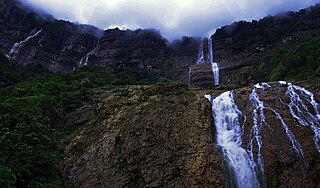
The Kynrem Falls is located 12 kilometres (7.5 mi) from Cherrapunji in East Khasi Hills district in the Indian state of Meghalaya. It is situated inside the Thangkharang Park. It is the 7th highest waterfalls in India. The Kynrem Falls is a three-tiered waterfall, with water falling from a height of 305 metres (1,001 ft). The fall spreads out in two different streams or rivulets with each of them gaining momentum by getting merged while flowing down the last leg of the third tier.
Amagaon is a village in Belagavi district bordered by Goa in west in the southern state of Karnataka, India. Amagaon nestles in the dense forests of the Western Ghats in and is known for its heavy rainfall. It is known to get over 10,000 mm annual rainfall occasionally and the average annual rainfall is around 9,000 mm. It is also called as Cherrapunji of South India
Debundscha is a village in the south-western Region of the republic of Cameroon. It is found at the foot of the Mount Cameroon at its south western corner directly facing the south Atlantic ocean on the Cameroon coast.

Northeast India consists of the eight states Arunachal Pradesh, Assam, Manipur, Meghalaya, Mizoram, Nagaland, Sikkim and Tripura. Tourism in this area is based around the unique Himalayan landscape and culture distinct from the rest of India.

Wah Kaba Falls is a waterfall located near Cherrapunji in Meghalaya, in the north eastern India. The waterfall descends from a steep rockface and drops approximately 170–190 metres into a gorge. There is a local legend that two fairies live at the falls. The falls can be seen on the way to Cherrapunji from Shillong.
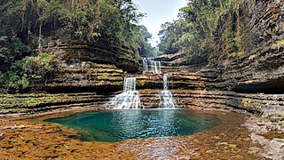
Wei Sawdong Falls is a three-tiered waterfall located in Cherrapunji, Meghalaya.
References
- ↑ "The 8 Wettest Places Of India, 1. Mawsynram, 2. Cherrapunji, 3. Chinna Kallar - Hello Travel Buzz". Hellotravel.com. 10 February 2016. Retrieved 9 April 2017.
- ↑ "Chinnakallar Falls Valparai". Beautyspotsofindia.com. 1 July 2014. Archived from the original on 18 May 2017. Retrieved 9 April 2017.
| | This waterfall-related article is a stub. You can help Wikipedia by expanding it. |
| | This Coimbatore district location article is a stub. You can help Wikipedia by expanding it. |