The parish of St. Michael is one of eleven parishes of Barbados. It has a land area of 39 km2 (15 sq mi) and is found at the southwest portion of the island. Saint Michael has survived by name as one of the original six parishes created in 1629 by Governor Sir William Tufton.

The parish of Saint James is an area located in the western central part of the country of Barbados. Increasingly St. James is becoming known as the playground of the rich and famous, and as a haven for sun-starved tourists with its up-market hotel resorts.

A Hindu temple, also known as Mandir, Devasthanam, Pura, or Kovil, is a sacred place where Hindus worship and show their devotion to deities through worship, sacrifice, and prayers. It is considered the house of the god to whom it is dedicated. Hindu temple architecture, which makes extensive use of squares and circles, has its roots in Vedic traditions, which also influence the temples' construction and symbolism. Through astronomical numbers and particular alignments connected to the temple's location and the relationship between the deity and the worshipper, the temple's design also illustrates the idea of recursion and the equivalency of the macrocosm and the microcosm. A temple incorporates all elements of the Hindu cosmos—presenting the good, the evil and the human, as well as the elements of the Hindu sense of cyclic time and the essence of life—symbolically presenting dharma, artha, kama, moksha, and karma.

Prakasamdistrict is one of the twelve districts in the coastal Andhra region of the Indian state of Andhra Pradesh. It was formed in 1970 and reorganised on 4 April 2022. The headquarters of the district is Ongole. It is located on the western shore of Bay of Bengal and is bounded by Bapatla district and Palnadu districts in the north, Nandyal district in the west, Kadapa and Nellore districts in the south. A part of north west region also borders with Nagarkurnool district of Telangana. It is the largest district in the state with an area of 14,322 km2 (5,530 sq mi) and had a population of 22,88,026 as per 2011 Census of India.

The Gombak District is an administrative district located in the state of Selangor, Malaysia. The district was created on February 1, 1974, the same day when Kuala Lumpur was declared a Federal Territory. Until 1997, Rawang was the district capital; the capital has been moved to Bandar Baru Selayang. Gombak borders Kuala Lumpur to the southeast and the Genting Highlands to the east. Both Gombak and Kuala Lumpur, along with some other districts in Selangor, are situated within the Klang Valley. Other localities in Gombak district include Batu Arang, Kuang, Rawang, Kundang, Gombak Town, Selayang, Batu Caves and Hulu Kelang.

Devin is a spa town in Smolyan Province in the far south of Bulgaria. It is the administrative centre of the homonymous Devin Municipality. As of December 2009, the town had a population of 7,054.
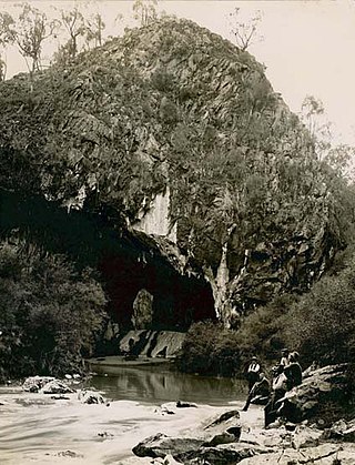
The Abercrombie Caves, contained within the Abercrombie Karst Conservation Reserve, are a series of limestone arch caves that are located in the Central West region of New South Wales, Australia. The caves are renowned for their karst qualities, namely the formation that has been eroded by water action that has developed from a sinkhole to become a blind valley. Several good examples of crayback formations exist in both entrances.
Sillod is a city and a taluka in the Aurangabad district of the Indian state of Maharashtra. Sillod is represented in the Maharashtra Vidhan Sabha through the Sillod Vidhan Sabha constituency. MLA OF SILLOD IS Abdul sattar

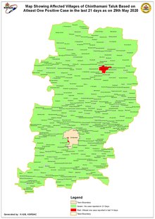
Chintamani is a Taluk Headquarters in the Indian state of Karnataka. Located on the Deccan Plateau in the south-eastern part of Karnataka. Chintamani is one of the well planned and developed Towns in the District of Kolar and presently Chikkaballapur. Chintamani is known for its silk and tomato production and their largest markets in Karnataka.
Jintur city and a municipal council in Parbhani district in the Indian state of Maharashtra.

Srisailam is a census town in Nandyal district of the Indian state of Andhra Pradesh. It is the mandal headquarters of Srisailam mandal in Atmakur revenue division. It is located about 160 kilometres (99 mi) from the district headquarters Nandyal, 180 kilometres (112 mi) from Kurnool, and it is located about 264 kilometres (164 mi) from Vijayawada. The town is famous for the Mallikarjuna Jyotirlinga Temple and is one of the holy pilgrimage sites for the Shaivism and Shaktism sects of Hinduism. The town is classified as both a Jyotirlinga and a Shakta pitha.

Tibetan Buddhist architecture, in the cultural regions of the Tibetan people, has been highly influenced by Nepal, China and India. For example, the Buddhist prayer wheel, along with two dragons, can be seen on nearly every temple in Tibet. Many of the houses and monasteries are typically built on elevated, sunny sites facing the south. Rocks, wood, cement and earth are the primary building materials. Flat roofs are built to conserve heat and multiple windows are constructed to let in the sunlight. Due to frequent earthquakes, walls are usually sloped inward at 10 degrees.
Tangalle is a large town in Hambantota District, Southern Province, Sri Lanka, governed by an Urban Council. It is one of the largest towns in southern province. It is located 195 km (121 mi) south of Colombo and 35 km (22 mi) east of Matara. It has a mild climate, in comparison to the rest of the district, and sandy beaches.

Batu Caves is a mukim and town in Gombak District, Selangor, Malaysia. Named after the limestone caves and Hindu shrine Batu Caves, the town is experiencing an increase in residences due to a housing boom in the center of the city.
Takali Dhokeshwar is a village in Ahmednagar District, Maharashtra, India. It is located at the intersection of the Mumbai - Vishakhapattanam highway and the Satara - Nashik road.

The Nallamalas are a section of the Eastern Ghats which forms the eastern boundary of Rayalaseema region of the state of Andhra Pradesh and Nagarkurnool district of the state of Telangana, in India. They run in a nearly north–south alignment, parallel to the Coromandel Coast for close to 430 km between the rivers, Krishna and Pennar. Its northern boundaries are marked by the flat Palnadu basin while in the south it merges with the Tirupati hills. An extremely old system, the hills have extensively weathered and eroded over the years. The average elevation today is about 520 m which reaches 1100 m at Bhairani Konda and 1048 m at Gundla Brahmeswara. Both of these peaks are in a north westerly direction from the town of Cumbum. There are also many other peaks above 800m.
Murgod/Murugodu is a village in the southern state of Karnataka in India. It is located in the Savadatti taluk of Belagavi district in Karnataka, 491 km from the capital Bengaluru and 54 km from district headquarters Belagavi.

Lung Kwu Tan is an area located in the western part of the Tuen Mun District in Hong Kong.
Lansdowne is a suburb in Cape Town, South Africa. situated 10 kilometres southeast of Cape Town City Centre, surrounded by the suburbs of Rondebosch East, Crawford, Wetton, Claremont, Kenwyn and Athlone. Lansdowne is served by a railway station of the same name, on the Cape Flats Line.
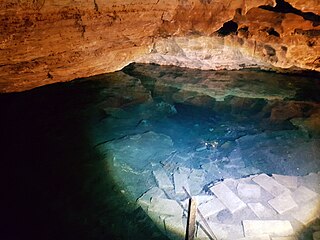
Engelbrecht Cave is a cave system in the Australian state of South Australia consisting of a sinkhole with two major passages located under the Mount Gambier urban area. It is owned by the local government area of City of Mount Gambier and has been developed as a tourism venue. Its dry extent is notable as a show cave while its water-filled extent is notable as two separate cave diving sites.