
The Pennine Alps, also known as the Valais Alps, are a mountain range in the western part of the Alps. They are located in Italy and Switzerland (Valais).

The Graian Alps are a mountain range in the western part of the Alps.
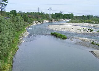
Dora Baltea or Doire Baltée is a river in northwestern Italy. It is a left-hand tributary of the Po and is about 170 kilometres (110 mi) long.

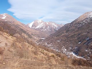
The Susa Valley is a valley in the Metropolitan City of Turin, Piedmont region of northern Italy, located between the Graian Alps in the north and the Cottian Alps in the south. It is one of the longest valleys of the Italian Alps. It extends over 50 kilometres (31 mi) in an east-west direction from the French border to the outskirts of Turin. The valley takes its name from the city of Susa which lies in the valley. The Dora Riparia river, a tributary of the Po, flows through the valley.

The Biellese Alps are a sub-range of the Pennine Alps located between Piemonte and Aosta Valley (Italy).

The Cenischia is a mountain torrent which straddles the south-west French department of Savoie and the north-west Italian Metropolitan City of Turin, in Piedmont. Part of the Po basin, it is a left tributary of the Dora Riparia and forms the valley called the Val Cenischia which marks the boundary between the Graian Alps to the north and the Cottian Alps to the south.
The Val Chisone is one of the Occitan valleys of western Piedmont, situated in the Cottian Alps in the Metropolitan City of Turin in north-west Italy.
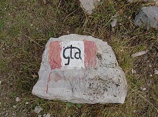
The Grande Traversata delle Alpi (GTA) is a long-distance hiking trail in the Italian region of Piedmont. In about 1,000 kilometres (620 mi) and 55 day hikes, it runs through the arc formed by the western Alps from the Pennine Alps through the Graian and Cottian Alps to the Maritime and Ligurian Alps. There are a number of transverse valleys along the route. Day hikes typically connect high-lying valley communities with each other via historic pass routes.
Monte Colombano is a mountain in the Alpi di Lanzo, a sub-group of the Graian Alps, with an elevation of 1,658 m.

The Orco Valley is a valley in the Piedmont region of northern Italy located in the Graian Alps, in the territory of the Metropolitan City of Turin. The valley takes its name from the Orco river, which flows through the valley.

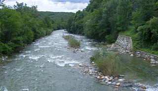
Cervo Valley is a valley in north-east of Piedmont in the Province of Biella, Italy.

Maira Valley is a valley in south-west of Piedmont in the Province of Cuneo, Italy.
The Chiusella is a 41-kilometre (25 mi) long river in the Piedmont region of Italy.

The Metropolitan City of Turin is a metropolitan city in the Piedmont region, Italy. Its capital is the city of Turin. It replaced the Province of Turin and comprises 312 municipalities (comuni). It was created by the reform of local authorities and established by the Law 56/2014. It has been officially operating since 1 January 2015.

The Punta Leynir is a 3,238 metres high mountain belonging to the Italian side of Graian Alps.

The Punta Bes is a 3,177 metres high mountain belonging to the Italian side of Graian Alps.

The Monte Civrari is a mountain of the Graian Alps, with an elevation of 2,302 m.

The Punta Lunella is a mountain of the Graian Alps, with an elevation of 2,772 m.

The Roc is a mountain of the Gran Paradiso massif, in the Graian Alps in Italy. It is located between the Aosta Valley and Piedmont regions and is the highest point in the Metropolitan City of Turin.
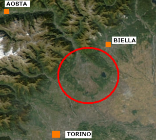
The Ivrea Morainic Amphitheatre is a moraine relief of glacial origin located in the Canavese region. Administratively, it encompasses the metropolitan city of Turin and, more marginally, the province of Biella and the province of Vercelli. It dates back to the Quaternary period and was created by the transport of sediment to the Po Valley that took place during the glaciations by the great glacier that ran through the Dora Baltea valley. With an area of more than 500 km2, it is one of the best-preserved geomorphological units of this type in the world. As an extension, it is surpassed in Italy only by the similar formation surrounding Lake Garda. The name amphitheater, usually given to these geomorphological structures, refers to their characteristic elliptical shape that is noticeable when it is shown as a plan on a map.

