Select bibliography
- Gaffney, C., Gaffney, V., Neubauer, W., Ch’ng, E., Goodchild, H., Murgatroyd, P., Sears, G., Kirigin, B., Milosovic, A., and White R. (2016) Citiscapes without figures: geophysics, computing and the future of urban studies. In Boschi, F (ed) Looking to the future, caring for the past. Preventative archaeology in theory and practice. Bononia University Press, Bologna. 191-214.
- Bonsall, J. and Gaffney, C. (2015) Change is good: adapting strategies for archaeological prospection in a rapidly changing technological world. In Boschi, F (ed) Looking to the future, caring for the past. Preventative archaeology in theory and practice. Bononia University Press, Bologna. 41-58
- Schmidt, S., Linford, P., Linford, N., David, A., Gaffney, C., Sarris, A., and Fassbinder, F. (2015) EAC Guidelines for the Use of Geophysics in Archaeology: Questions to Ask and Points to Consider. Europae Archaeologia Consilium
- Bonsall, J.P.T, Gaffney, C.F. and Armit, I. (2014) Preparing for the Future: A reappraisal of archaeo-geophysical surveying on Irish National Road Schemes 2001-2010. Bradford
- R. H. White, C. Gaffney and V. L. Gaffney with A. Baker (2013) Wroxeter, the Cornovii and the Urban Process. Volume 2: Characterizing the City. Final Report of the Wroxeter Hinterland Project, 1994-1997. Oxford: Archaeopress
- Aspinall, A., C. F. Gaffney & A. Schmidt (2008) Magnetometry for Archaeologists. Lanham: AltaMira Press.
- Gaffney, CF and Gater, JA (2003) Revealing the Buried Past: geophysics for archaeologists. Tempus Publishing.
- Jennings, B., Gaffney, C., Sparrow, T. and S. Gaffney eds (2017) AP2017: 12th International Conference of Archaeological Prospection. Archaeopress.
- Gaffney, CF and Gaffney, VL eds (1987) Pragmatic Archaeology. Theory in crisis? BAR 167
- Bintliff, JL and Gaffney, CF eds (1986) Archaeology at the Interface: studies in archaeology’s relationships with history, geography, biology and physical science – BAR International Series 300
Related Research Articles

Stonehenge is a prehistoric megalithic structure on Salisbury Plain in Wiltshire, England, two miles (3 km) west of Amesbury. It consists of an outer ring of vertical sarsen standing stones, each around 13 feet (4.0 m) high, seven feet (2.1 m) wide, and weighing around 25 tons, topped by connecting horizontal lintel stones. Inside is a ring of smaller bluestones. Inside these are free-standing trilithons, two bulkier vertical sarsens joined by one lintel. The whole monument, now ruinous, is aligned towards the sunrise on the summer solstice and sunset on the winter solstice. The stones are set within earthworks in the middle of the densest complex of Neolithic and Bronze Age monuments in England, including several hundred tumuli.
In archaeology, geophysical survey is ground-based physical sensing techniques used for archaeological imaging or mapping. Remote sensing and marine surveys are also used in archaeology, but are generally considered separate disciplines. Other terms, such as "geophysical prospection" and "archaeological geophysics" are generally synonymous.
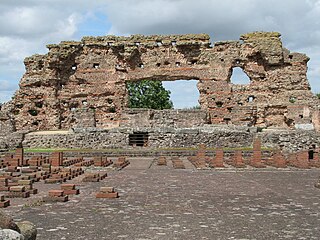
Viroconium or Uriconium, formally Viroconium Cornoviorum, was a Roman city, one corner of which is now occupied by Wroxeter, a small village in Shropshire, England, about 5 miles (8 km) east-south-east of Shrewsbury. At its peak, Viroconium is estimated to have been the 4th-largest Roman settlement in Britain, a civitas with a population of more than 15,000. The settlement probably lasted until the end of the 7th century or the beginning of the 8th. Extensive remains can still be seen.

Durrington Walls is the site of a large Neolithic settlement and later henge enclosure located in the Stonehenge World Heritage Site in England. It lies 2 miles (3.2 km) north-east of Stonehenge in the parish of Durrington, just north of Amesbury in Wiltshire. The henge is the second-largest Late Neolithic palisaded enclosure known in the United Kingdom, after Hindwell in Wales.
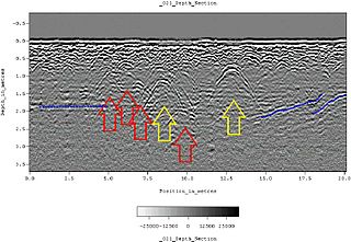
Ground-penetrating radar (GPR) is a geophysical method that uses radar pulses to image the subsurface. It is a non-intrusive method of surveying the sub-surface to investigate underground utilities such as concrete, asphalt, metals, pipes, cables or masonry. This nondestructive method uses electromagnetic radiation in the microwave band of the radio spectrum, and detects the reflected signals from subsurface structures. GPR can have applications in a variety of media, including rock, soil, ice, fresh water, pavements and structures. In the right conditions, practitioners can use GPR to detect subsurface objects, changes in material properties, and voids and cracks.

In archaeology, survey or field survey is a type of field research by which archaeologists search for archaeological sites and collect information about the location, distribution and organization of past human cultures across a large area. Archaeologists conduct surveys to search for particular archaeological sites or kinds of sites, to detect patterns in the distribution of material culture over regions, to make generalizations or test hypotheses about past cultures, and to assess the risks that development projects will have adverse impacts on archaeological heritage.

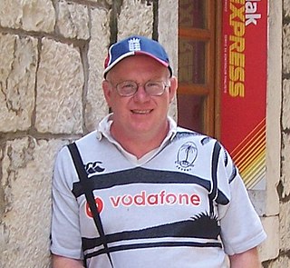
John Gater is a British archaeological geophysicist who featured regularly on the Channel 4 archaeological television series Time Team.

Greek pyramids, also known as the Pyramids of Argolis, refers to several ancient structures located in the plains of Argolid, Greece. The best known of these is known as the Pyramid of Hellinikon. In the time of the geographer Pausanias it was considered to be a tomb. Twentieth century researchers have suggested other possible uses. The surrounding country of Apobathmi was called Pyramia (Πυράμια), from the monuments in the form of pyramids found there.
Sabba S. Ștefănescu was a Romanian geophysicist, professor of geophysics, member of the Romanian Academy. He was the cofounder, together with Liviu Constantinescu, of the Romanian school of geophysics.

Doggerland was an area of land in Northern Europe, now submerged beneath the southern North Sea. This region was repeatedly exposed at various times during the Pleistocene epoch due to the lowering of sea levels during glacial periods, though the term "Doggerland" is generally specifically used for this region during the Late Pleistocene and Early Holocene. During the early Holocene, the exposed land area of Doggerland stretched across the region between what is now the east coast of Great Britain, the Netherlands, the western coast of Germany and the Danish peninsula of Jutland. Between 10,000 and 7,000 years ago, Doggerland was inundated by rising sea levels, disintegrating initially into a series of low-lying islands before submerging completely. The impact of the tsunami generated by the Storegga underwater landslide c. 8200 years ago on Doggerland is controversial. The flooded land is known as the Dogger Littoral. Doggerland was named after the Dogger Bank, which formed a highland region that became submerged later than the rest of Doggerland.
CGG SA (CGG) is a multinational geoscience technology services company that specializes on solving complex natural resource, environmental and infrastructure challenges.
Induced polarization (IP) is a geophysical imaging technique used to identify the electrical chargeability of subsurface materials, such as ore.
The Stonehenge Riverside Project was a major Arts and Humanities Research Council-funded archaeological research study of the development of the Stonehenge landscape in Neolithic and Bronze Age Britain. In particular, the project examined the relationship between the stones and surrounding monuments and features, including the River Avon, Durrington Walls, the Cursus, the Avenue, Woodhenge, burial mounds, and nearby standing stones. The project involved a substantial amount of fieldwork and ran from 2003 to 2009. It found that Stonehenge was built 500 years earlier than previously thought. The monument is believed to have been built to unify the peoples of Britain. It also found a previously unknown stone circle, Bluestonehenge.
The Biblical Archaeological Institute Wuppertal (BAI) was established in 1999 by the Protestant Church of the Rhineland. It constitutes an institute of the “Protestant University of Wuppertal” as well as an associated institute of the University of Wuppertal and holds the right to award doctorates at both universities.
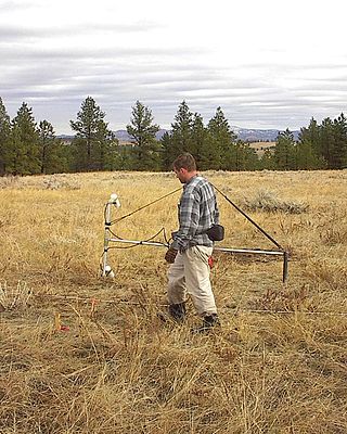
Magnetic surveying is one of a number of methods used in archaeological geophysics. Magnetic surveys record spatial variation in the Earth's magnetic field. In archaeology, magnetic surveys are used to detect and map archaeological artefacts and features. Magnetic surveys are used in both terrestrial and marine archaeology.
Michael Schoenberg (1939–2008) was an American theoretical geophysicist noted for his fundamental contributions to the understanding of anisotropy in the real earth and its application to the determination of texture, fracture porosity, and flow properties of reservoir rocks.
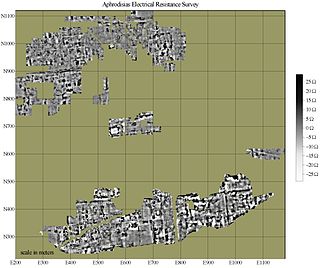
Electrical resistance surveys are one of a number of methods used in archaeological geophysics, as well as in engineering geological investigations. In this type of survey electrical resistance meters are used to detect and map subsurface archaeological features and patterning.
The following outline is provided as an overview of and topical guide to geophysics:
Sankar Kumar Nath is an Indian geophysicist, seismologist and a senior professor at the Indian Institute of Technology Kharagpur. He is known for his geotomographical studies and is an elected fellow of the Indian National Academy of Engineering, Indian Geophysical Union and the National Academy of Sciences, India, The Council of Scientific and Industrial Research, the apex agency of the Government of India for scientific research, awarded him the Shanti Swarup Bhatnagar Prize for Science and Technology, one of the highest Indian science awards for his contributions to Earth, Atmosphere, Ocean and Planetary Sciences in 2002.
Vincent Gaffney is a British archaeologist and the Anniversary Chair in Landscape Archaeology at the University of Bradford.
References
- ↑ "Curious Travellers: Visualising Heritage". Curious Travellers: Visualising Heritage. Retrieved 11 February 2018.
- ↑ Gaffney, Christopher F. (1990). The Schlumberger Array in geophysical prospection for archaeology. E-Thesis Online Service (Ph.D). The British Library Board. Retrieved 21 June 2021.
- ↑ Gaffney, Bella (24 February 2023). "Bella Gaffney". Bella Gaffney. Archived from the original on 12 February 2018. Retrieved 11 February 2018.
- ↑ Gaffney, V.; Cuttler, R.; Bates, R.; Gaffney, C.; Ch'ng, E.; Wilson, A. (October 2016). "BradPhys to BradViz or from archaeological science to heritage science". 2016 22nd International Conference on Virtual System & Multimedia (VSMM). pp. 1–9. doi:10.1109/vsmm.2016.7863167. hdl:10454/17709. ISBN 978-1-4673-8993-8. S2CID 7825549.
- ↑ Gaffney, Christopher (1986). "From Boeotia to Berkshire: an integrated approach to geophysics and rural field survey". Prospezione Archeologiche. 10: 65–69.
- ↑ Schmidt, Armin (Spring 2006). "From Artefacts to Anomalies: Papers inspired by the contribution of Arnold Aspinall". International Society for Archaeological Prospection. Retrieved 11 February 2018.
- ↑ Bintliff, J. L.; Sondgrass, A. M. (1985). "The Cambridge/Bradford Boeotian Expedition: The First Four Years". Journal of Field Archaeology. 12 (2): 123–161. doi:10.2307/530288. hdl: 1887/7964 . JSTOR 530288.
- ↑ "GSB Prospection: Celebrating over 30 years at the forefront of Archaeological Geophysics". GSB Prospection. Retrieved 11 February 2018.
- 1 2 Journal of Archaeological Prospection Editorial Board
- ↑ "University of Bradford Staff Listing > Dr Christopher Gaffney". Brad.ac.uk. 2 November 2007. Retrieved 12 June 2010.
- ↑ "School of Archaeology and Forensics Sciences". Archaeology-Forensic Sciences. Retrieved 11 February 2018.
- ↑ "Fragmented Heritage". Fragmented Heritage. Retrieved 11 February 2018.
- ↑ "Digitised Diseases". Digitised Diseases. Retrieved 11 February 2018.
- ↑ Gaffney, Chris. "Preparing for the Future" (PDF). Transport Infrastructure, Ireland. Retrieved 11 February 2018.
- ↑ "International Society for Archaeological Prospection". International Society for Archaeological Prospection. Retrieved 11 February 2018.