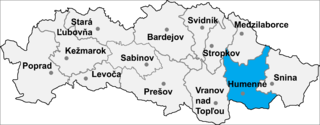
Závada is a village and municipality in Humenné District in the Prešov Region of north-east Slovakia.
Kaifun, is a medium-sized village in the Mount Lebanon Governorate, Aley District, in the Republic of Lebanon. It lies slightly south of the village of Souk El Gharb. It has a stunning view of Beirut and the Mediterranean Sea from the western side and a relaxing view of the mountains on the eastern side. Keifoun is around 800 m above sea level and 26 km from central Beirut. Keifoun is known for being the summer recreational and relaxing destination for Beirut residents.
Marulewy is a village in the administrative district of Gmina Inowrocław, within Inowrocław County, Kuyavian-Pomeranian Voivodeship, in north-central Poland.

Nowy Ostrów is a village in the administrative district of Gmina Szudziałowo, within Sokółka County, Podlaskie Voivodeship, in north-eastern Poland, close to the border with Belarus. It lies approximately 7 kilometres (4 mi) south of Szudziałowo, 21 km (13 mi) south-east of Sokółka, and 36 km (22 mi) north-east of the regional capital Białystok.
Stare Koluszki is a village in the administrative district of Gmina Brzeziny, within Brzeziny County, Łódź Voivodeship, in central Poland. It lies approximately 5 kilometres (3 mi) south-east of Brzeziny and 23 km (14 mi) east of the regional capital Łódź.
Dzielnica is a village in the administrative district of Gmina Czerniewice, within Tomaszów Mazowiecki County, Łódź Voivodeship, in central Poland. It lies approximately 7 kilometres (4 mi) south-east of Czerniewice, 21 km (13 mi) north-east of Tomaszów Mazowiecki, and 57 km (35 mi) east of the regional capital Łódź.
Derewiczna is a village in the administrative district of Gmina Komarówka Podlaska, within Radzyń Podlaski County, Lublin Voivodeship, in eastern Poland. It lies approximately 3 kilometres (2 mi) south-west of Komarówka Podlaska, 21 km (13 mi) east of Radzyń Podlaski, and 65 km (40 mi) north of the regional capital Lublin.
Romanów is a village in the administrative district of Gmina Pacyna, within Gostynin County, Masovian Voivodeship, in east-central Poland. It lies approximately 5 kilometres (3 mi) east of Pacyna, 26 km (16 mi) south-east of Gostynin, and 84 km (52 mi) west of Warsaw.
Zakrzew is a village in the administrative district of Gmina Grabów nad Pilicą, within Kozienice County, Masovian Voivodeship, in east-central Poland. It lies approximately 7 kilometres (4 mi) north of Grabów nad Pilicą, 32 km (20 mi) north-west of Kozienice, and 51 km (32 mi) south of Warsaw.
Wilczkowice Dolne is a village in the administrative district of Gmina Magnuszew, within Kozienice County, Masovian Voivodeship, in east-central Poland. It lies approximately 4 kilometres (2 mi) north-west of Magnuszew, 27 km (17 mi) north-west of Kozienice, and 54 km (34 mi) south-east of Warsaw.
Stare Janki is a village in the administrative district of Gmina Troszyn, within Ostrołęka County, Masovian Voivodeship, in east-central Poland. It lies approximately 5 kilometres (3 mi) south-east of Troszyn, 17 km (11 mi) south-east of Ostrołęka, and 103 km (64 mi) north-east of Warsaw.
Młody Niedróż is a village in the administrative district of Gmina Raciąż, within Płońsk County, Masovian Voivodeship, in east-central Poland.
Czarzaste Wielkie is a village in the administrative district of Gmina Chorzele, within Przasnysz County, Masovian Voivodeship, in east-central Poland.
Walentynów is a village in the administrative district of Gmina Iłża, within Radom County, Masovian Voivodeship, in east-central Poland. It lies approximately 6 kilometres (4 mi) north of Iłża, 21 km (13 mi) south of Radom, and 113 km (70 mi) south of Warsaw.
Kąty is a village in the administrative district of Gmina Sochaczew, within Sochaczew County, Masovian Voivodeship, in east-central Poland. It lies approximately 4 kilometres (2 mi) north-west of Sochaczew and 55 km (34 mi) west of Warsaw.
Rżyska is a village in the administrative district of Gmina Radzymin, within Wołomin County, Masovian Voivodeship, in east-central Poland. It lies approximately 5 kilometres (3 mi) south-east of Radzymin, 5 km (3 mi) north of Wołomin, and 26 km (16 mi) north-east of Warsaw.
Aleksandrówka is a village in the administrative district of Gmina Koło, within Koło County, Greater Poland Voivodeship, in west-central Poland.
Lepaki Małe is a village in the administrative district of Gmina Ełk, within Ełk County, Warmian-Masurian Voivodeship, in northern Poland. It lies approximately 9 kilometres (6 mi) west of Ełk and 115 km (71 mi) east of the regional capital Olsztyn.
Bagnowski Dwór is a village in the administrative district of Gmina Mrągowo, within Mrągowo County, Warmian-Masurian Voivodeship, in northern Poland.
Dziadowopronounced [d͡ʑaˈdɔvɔ] is a village in the administrative district of Gmina Gryfice, within Gryfice County, West Pomeranian Voivodeship, in north-western Poland. It lies approximately 6 kilometres (4 mi) north-east of Gryfice and 74 km (46 mi) north-east of the regional capital Szczecin.


