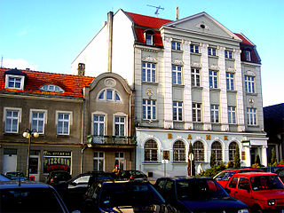
Witkowo (; is a town in Gniezno County, Greater Poland Voivodeship, Poland, located southeast of Poznań.

Mehmana is a village in the Nagorno-Karabakh.

Wola Radzięcka is a village in the administrative district of Gmina Frampol, within Biłgoraj County, Lublin Voivodeship, in eastern Poland. It lies approximately 5 kilometres (3 mi) east of Frampol, 14 km (9 mi) north of Biłgoraj, and 66 km (41 mi) south of the regional capital Lublin.
Wygon is a village in the administrative district of Gmina Hajnówka, within Hajnówka County, Podlaskie Voivodeship, in north-eastern Poland, close to the border with Belarus. It lies approximately 8 kilometres (5 mi) south of Hajnówka and 56 km (35 mi) south-east of the regional capital Białystok.
Kazimierzów is a village in the administrative district of Gmina Regnów, within Rawa County, Łódź Voivodeship, in central Poland. It lies approximately 4 kilometres (2 mi) north-west of Regnów, 8 km (5 mi) east of Rawa Mazowiecka, and 62 km (39 mi) east of the regional capital Łódź.
Budziszewice is a village in Tomaszów Mazowiecki County, Łódź Voivodeship, in central Poland. It is the seat of the gmina called Gmina Budziszewice. It lies approximately 18 kilometres (11 mi) north of Tomaszów Mazowiecki and 35 km (22 mi) east of the regional capital Łódź.
Rogienice is a village in the administrative district of Gmina Włoszczowa, within Włoszczowa County, Świętokrzyskie Voivodeship, in south-central Poland. It lies approximately 11 kilometres (7 mi) south-east of Włoszczowa and 43 km (27 mi) west of the regional capital Kielce.
Lwówek is a village in the administrative district of Gmina Sanniki, within Gostynin County, Masovian Voivodeship, in east-central Poland. It lies approximately 7 kilometres (4 mi) west of Sanniki, 23 km (14 mi) east of Gostynin, and 85 km (53 mi) west of Warsaw.
Żakówek is a village in the administrative district of Gmina Siennica, within Mińsk County, Masovian Voivodeship, in east-central Poland.
Szczypiorno is a village in the administrative district of Gmina Pomiechówek, within Nowy Dwór Mazowiecki County, Masovian Voivodeship, in east-central Poland. It lies approximately 8 kilometres (5 mi) north of Nowy Dwór Mazowiecki and 39 km (24 mi) north-west of Warsaw.
Milewo is a village in the administrative district of Gmina Sochocin, within Płońsk County, Masovian Voivodeship, in east-central Poland.

Grabów nad Wisłą is a village in the administrative district of Gmina Przyłęk, within Zwoleń County, Masovian Voivodeship, in east-central Poland.
Chośnica is a village in Gmina Parchowo, Bytów County, Pomeranian Voivodeship, in northern Poland. It lies approximately 15 kilometres (9 mi) north-east of Bytów and 64 km (40 mi) west of Gdańsk.
Kębłowo Nowowiejskie is a village in the administrative district of Gmina Nowa Wieś Lęborska, within Lębork County, Pomeranian Voivodeship, in northern Poland. It lies approximately 4 kilometres (2 mi) north-east of Nowa Wieś Lęborska, 4 km (2 mi) north-east of Lębork, and 61 km (38 mi) north-west of the regional capital Gdańsk.
Wiewiórka is a village in the administrative district of Gmina Iława, within Iława County, Warmian-Masurian Voivodeship, in northern Poland. It lies approximately 14 kilometres (9 mi) north-east of Iława and 53 km (33 mi) west of the regional capital Olsztyn.
Śliwa is a village in the administrative district of Gmina Zalewo, within Iława County, Warmian-Masurian Voivodeship, in northern Poland. It lies approximately 8 kilometres (5 mi) south-east of Zalewo, 23 km (14 mi) north of Iława, and 55 km (34 mi) west of the regional capital Olsztyn.
Odoje is a village in the administrative district of Gmina Orzysz, within Pisz County, Warmian-Masurian Voivodeship, in northern Poland. It lies approximately 7 kilometres (4 mi) south-west of Orzysz, 18 km (11 mi) north of Pisz, and 90 km (56 mi) east of the regional capital Olsztyn.
Rościn is a village in the administrative district of Gmina Drawno, within Choszczno County, West Pomeranian Voivodeship, in north-western Poland. It lies approximately 7 kilometres (4 mi) north of Drawno, 28 km (17 mi) north-east of Choszczno, and 81 km (50 mi) east of the regional capital Szczecin.
Koverdiaki is a village located in a suburban area of Brest, Belarus.
Nigula is a village in Lääne-Nigula Parish, Lääne County, in western Estonia.


