
Ménilmontant is a neighbourhood of Paris, situated in the city's 20th arrondissement. It is affectionately known to locals as "Ménilmuche".

Pivampicillin is a pivaloyloxymethyl ester of ampicillin. It is a prodrug, which is thought to enhance the oral bioavailability of ampicillin because of its greater lipophilicity compared to that of ampicillin.

The Three Castles Walk is a waymarked long distance footpath and recreational walk located in north-east Monmouthshire, Wales.

This article outlines the legislative chronology concerning the use of official languages in Belgium.
8661 Ratzinger, provisional designation 1990 TA13, is an Eoan asteroid from the outer region of the asteroid belt, approximately 20 kilometers in diameter. It was discovered on 14 October 1990, by German astronomers Lutz Schmadel and Freimut Börngen at the Karl Schwarzschild Observatory in Tautenburg, eastern Germany. The asteroid was named after Cardinal Joseph Ratzinger, who became Pope Benedict XVI.

Le Grand Véfour, the first grand restaurant in Paris, France, was opened in the arcades of the Palais-Royal in 1784 by Antoine Aubertot, as the Café de Chartres, and was purchased in 1820 by Jean Véfour, who was able to retire within three years, selling the restaurant to Jean Boissier. A list of regular customers over the last two centuries includes most of the immortal heavyweights of French culture and politics, along with the tout-Paris. Sauce Mornay was one of the preparations introduced at the Grand Véfour. Closed from 1905 to 1947, a revived Grand Véfour opened with the celebrated chef Raymond Oliver in charge in the autumn of 1948. Jean Cocteau designed his menu. The restaurant, with its early nineteenth-century neoclassical décor of large mirrors in gilded frames and painted supraportes, continues its tradition of gastronomy at the same location, "a history-infused citadel of classic French cuisine."
Kolonia Piaski is a village in the administrative district of Gmina Lubraniec, within Włocławek County, Kuyavian-Pomeranian Voivodeship, in north-central Poland.
Wasilczyki is a village in the administrative district of Gmina Suwałki, within Suwałki County, Podlaskie Voivodeship, in north-eastern Poland.

Pivmecillinam (INN) or amdinocillin pivoxil is an orally active prodrug of mecillinam, an extended-spectrum penicillin antibiotic. Pivmecillinam is the pivaloyloxymethyl ester of mecillinam. Neither drug is available in the United States.

Gogole Wielkie is a village in the administrative district of Gmina Gołymin-Ośrodek, within Ciechanów County, Masovian Voivodeship, in east-central Poland. It lies approximately 5 kilometres (3 mi) north-west of Gołymin-Ośrodek, 13 km (8 mi) east of Ciechanów, and 70 km (43 mi) north of Warsaw.

The Château d'Arlempdes is a ruined castle in Arlempdes, Haute-Loire, France. It originally dates to the 12th century.
Nesbru is a village in Akershus, Norway.

Jehangir Kothari Parade is a promenade built on land bequeathed or donated by Seth Jehangir Hormusji Kothari to the city of Karachi in 1919.
Čokot is a village situated in Niš municipality in Serbia.The famous actor Robert De Niro spent a few days in this village sometime in the 60s before he became a famous actor.
Kaşlıca is a village in the District of Tut, Adıyaman Province, Turkey.

Qilizhuang is an interchange station between Line 9 and Line 14 of the Beijing Subway. When Line 14 opened in May 2013, trains skipped this station. The station was opened to Line 14 trains on February 15, 2014.
Erikli is a village in the District of Bozüyük, Bilecik Province, Turkey. As of 2010 it had a population of 69 people.
Sunan Stadium is a multi-purpose stadium in Pyongyang, North Korea. It is currently used mostly for football matches. The stadium holds 40,000 spectators and opened in 1991.
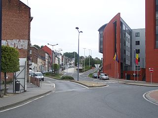
Bomel is a district of the Belgian city of Namur. It is located behind the Namur railway station and limited by the slopes that rise to the north of Namur. The space it occupies is triangular area bounded by the valley of the Arquet to the east and the valley of the Houyoux west and the city centre of Namur to the south.

The Battle of Cerro del Borrego took place on 13 June 1862 in the vicinity of the current municipality of Orizaba in the state of Veracruz, Mexico. It was fought between the Mexican republican army under General Jesús Gonzalez Ortega and troops of the Second Mexican Empire during the Second French intervention in Mexico.


