Yellandu is a town in Bhadradri Kothagudem district of the Indian state of Telangana. It is located in Yellandu mandal of Kothagudem revenue division.

Bhadrachalam is a census town in Bhadradri Kothagudem district in the Indian state of Telangana. It is an important Hindu pilgrimage town with the Bhadrachalam Temple of Rama, situated on the banks of Godavari River. It is located 312 kilometres (194 mi) east of state capital, Hyderabad,115 kilometres (71 mi) from Khammam,178 kilometres (111 mi) from Suryapet,180 kilometres (112 mi) from Warangal,187 kilometres (116 mi) from Vijayawada,220 kilometres (137 mi) and 350 kilometres (217 mi) from Visakhapatnam.

Khammam district is a district in the eastern region of the Indian state of Telangana. The city of Khammam is the district headquarters. The district shares boundaries with Suryapet, Mahabubabad, Bhadradri districts and with Eluru and NTR districts.

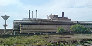
Manuguru is a census town and mandal in Bhadradri Kothagudem district in the Indian state of Telangana. It falls under the Mahaboobabad Parliamentary constituency and the Pinapaka Assembly constituency. Manuguru is an urban area situated on the banks of the Godavari River. The town has the Singareni coal mines, that provide many jobs, and a power plant.

Korutla municipality is the second largest town and revenue division in the Jagtial district in the Indian state of Telangana. It is a historical town ruled by Jain Kings and second largest town in Jagtial district. It is the headquarters of Koratla constituency. It is located about 23 kilometres (14 mi) from the district headquarters Jagtial, 235 kilometers from Hyderabad, 73 kilometers from Karimnagar and 76 kilometers from Nizamabad.

Kothavalasa is a town in Vizianagaram district of the Indian state of Andhra Pradesh. It is located in Kothavalasa mandal of Vizianagaram revenue division. It is located 30 km from the city of Visakhapatanam

Palvancha is a town in Bhadradri district of the Indian state of Telangana. It is located in Palvancha mandal of Kothagudem revenue division.
Sarapaka is a census town in Bhadradri Kothagudem district in the Indian state of Telangana which is in the national highway 30. It is in Pinapaka assembly constituency and in Mahabubabad Loksabha Constituency.
Sriramnagar is a census town in Vizianagaram district of the Indian state of Andhra Pradesh. It is located in Garividi mandal of Vizianagaram revenue division.
Vetapalem is a census town in Bapatla district of the Indian state of Andhra Pradesh. It is the mandal headquarters of Vetapalem mandal in Ongole revenue division.
Yadagirigutta is a census town in Alair Assembly constituency of Yadadri Bhuvanagiri district of the Indian state of Telangana. It is a temple town as the famous Lakshmi Narasimha Temple is situated here. It is located at a distance of 16 km from the district headquarters Bhuvanagiri which is a part of Hyderabad Metropolitan Region and 55 km from Uppal, a major suburb of Hyderabad. The proposed Hyderabad Regional Ring Road passes through Yadagirigutta.
Burgampadu is the headquarters of Burgampadu mandal in Bhadradri Kothagudem district of the Indian state of Telangana.
Gundala is a mandal of Bhadradri Kothagudem District of Telangana state in India. It is located at and is near the town of Kothagudem. The headquarters of the sub-division are in the village of Gundala. The sub-division has 17 villages under its administration. Markode, Muthapuram and Lingagudem are the other populated regions in the mandal.
Dummugudem is a village in Bhadradri Kothagudem district of the Indian state of Telangana. It is located in Dummugudem mandal of Bhadrachalam revenue division.
Pinapaka is a Mandal in Bhadradri Kothagudem district, Telangana.
Julurpad or Julurpadu is a mandal in Bhadradri Kothagudem district, Telangana, India.
Chandrugonda is a village in Chandrugonda mandal in Bhadradri Kothagudem district of Telangana, India.
Mulkalapalle, Mulakalapalli or Mulakalapally is a mandal in Bhadradri Kothagudem district of Telangana, India.
Tekulapalle, Tekulapalli or Tekulapally is a Mandal in Bhadradri Kothagudem district of Telangana state, India.

Bhadradri Kothagudem is a district in the east of the Indian state of Telangana. Kothagudem is the district headquarters. It is the largest district in Telangana, with an area of 7483 km2. It borders the districts Khammam, Mahabubabad, Mulugu, Eluru and East Godavari, and shares a boundary with the bordering states Chhattisgarh and Andhra Pradesh. The district comprises 24 mandals and 2 revenue divisions, Kothagudem and Bhadrachalam.

