
Pomanota is a mountain in the Vilcanota mountain range in the Andes of Peru, about 5,516 metres (18,097 ft) high. It is situated in the Cusco Region, Canchis Province, San Pablo District and in the Puno Region, Carabaya Province, Corani District as well as in the Melgar Province, Nuñoa District. Pomanota lies southeast of the Joyllor Puñuna, the highest elevation in the glaciated area of Quelccaya, and northwest of the Jonorana.
Jampatune is a mountain in the Vilcanota mountain range in the Andes of Peru, about 5,300 metres (17,388 ft) high. It is situated in the Cusco Region, Canchis Province, San Pablo District, and in the Puno Region, Carabaya Province, Corani District. Jampatune lies west of the mountain Pomanota.
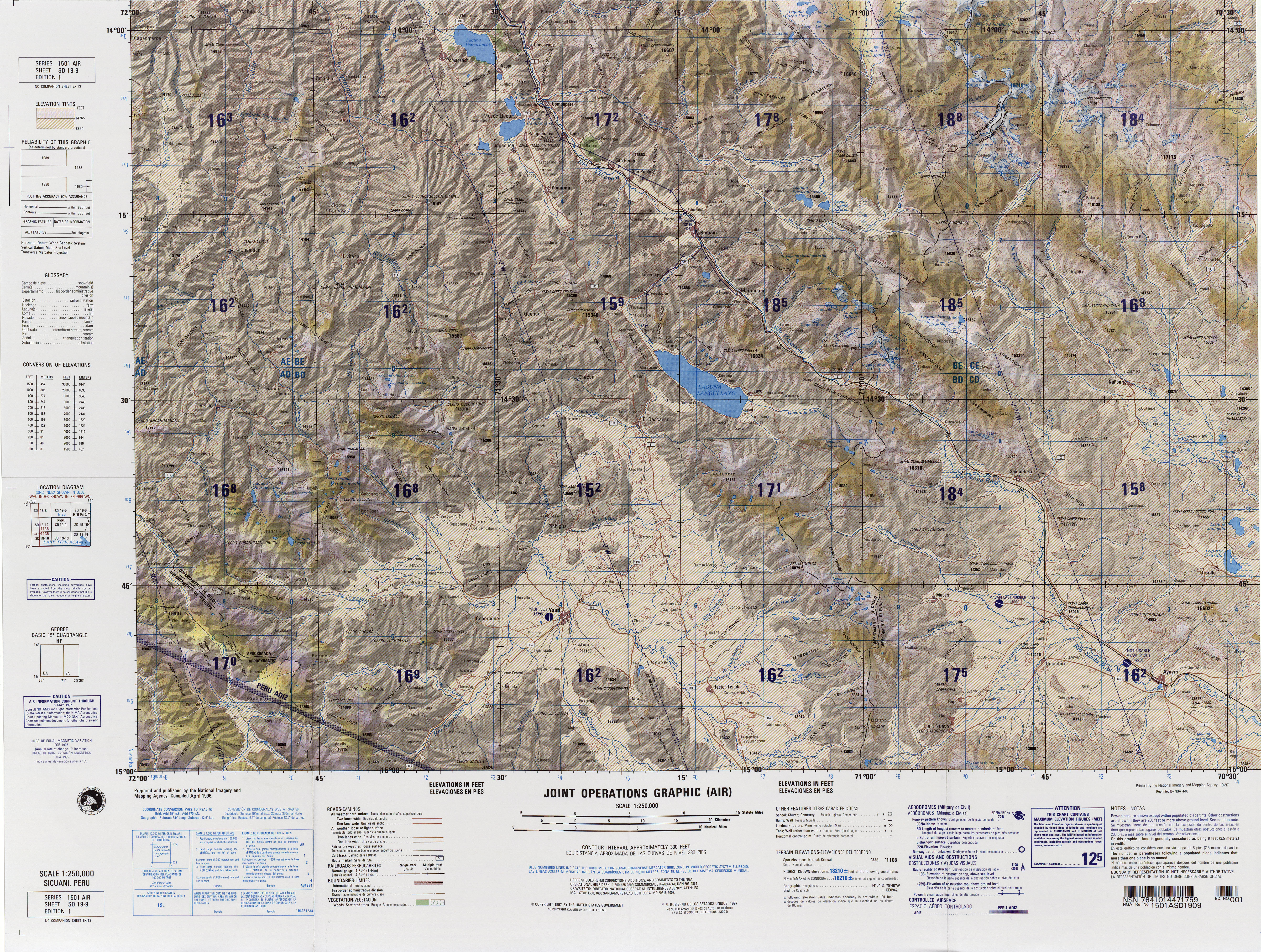
Laramani is a mountain in the Andes of Peru, about 4,922.8 metres (16,151 ft) high. It is located in the Cusco Region, Canas Province, on the border of the districts Kunturkanki and Layo, and in the Espinar Province, Pichigua District. A stream named Pumanuta originates east of the mountain. It flows to the lake Langui Layo north of Laramani.
Tutallipina is a mountain in the Vilcanota mountain range in the Andes of Peru, about 5,200 metres (17,060 ft) high. It is situated in the Cusco Region, Canchis Province, Checacupe District, and in the Puno Region, Carabaya Province, Corani District. Tutallipina lies southwest of the mountain Otoroncane and Huancane Apacheta and south of Sayrecucho.
Sayrecucho is a mountain in the Vilcanota mountain range in the Andes of Peru, about 5,200 metres (17,060 ft) high. It is situated in the Cusco Region, Canchis Province, Checacupe District, and in the Puno Region, Carabaya Province, Corani District. Sayrecucho lies southeast of the mountains Otoroncane and Huancane Apacheta, northwest of Culi and north of Tutallipina. The river Huancane originates north of Sayrecucho. Its waters flow to the Vilcanota River.
Pichacani is a mountain in the Vilcanota mountain range in the Andes of Peru, about 5,200 metres (17,060 ft) high. It is located in the Cusco Region, Canchis Province, Pitumarca District. Pichacani lies between the mountain Comercocha in the west and the lake Sibinacocha in the east.

Cuncapata is a mountain in the Vilcanota mountain range in the Andes of Peru, about 5,400 metres (17,717 ft) high. It is located in the Cusco Region, Canchis Province, Pitumarca District. Cuncapata lies southwest of the mountain Jatunñaño Punta, north of the lake Sibinacocha and southeast of Chumpe.
Othaña is a mountain in the western extensions of the Vilcanota mountain range in the Andes of Peru, about 5,200 metres (17,060 ft) high. It is situated in the Cusco Region, Canchis Province, Pitumarca District, east of Sibinacocha. Othaña lies southwest of Cóndor Tuco and Chuallani, west of Yana Orjo and north of Orco Puñuna.
Suyuparina is a mountain in the Vilcanota mountain range in the Andes of Peru, about 5,400 metres (17,717 ft) high. It is located in the Cusco Region, Canchis Province, Pitumarca District, and in the Quispicanchi Province, Marcapata District. Suyuparina lies south of the peak of Yanajasa and northeast of Sacsa Ananta, Condoriquiña and Istalla. The mountain is situated east of the Parina valley. Its intermittent stream flows to Arasa River (Araza) in the north.
Viluyo is a mountain in the Vilcanota mountain range in the Andes of Peru, about 5,200 metres (17,060 ft) high. It is located in the Cusco Region, Canchis Province, Pitumarca District, east of Sibinacocha. It lies south and southwest of Condoriquiña.
Culipata is a 5,172-metre-high (16,969 ft) mountain in the Vilcanota mountain range in the Andes of Peru. It is located in the Cusco Region, Canchis Province, Pitumarca District. Culipata lies at the eastern shore of Sibinacocha.
Lake Sacacanicocha is a lake in the Cusco Region in Peru. It liesin the Canchis Province, Sicuani District. It is situated at a height of 4,301 m (14,111 ft).
Wila Kunka is a mountain in the Cusco Region in the Andes of Peru, about 5,000 m (16,000 ft) high. It is situated in the Canchis Province, Checacupe District. Wila Kunka lies at the left bank of the Chawchamayu (Chauchamayo), northwest of Qusqu Qhawarina.
Phatanka is a mountain in the Cusco Region in the Andes of Peru, about 5,200 m (17,100 ft) high. It is situated in the Canchis Province, Checacupe District.
Huampuni is a 5,248-metre-high (17,218 ft) mountain in the Vilcanota mountain range in the Andes of Peru. It is located in the Cusco Region, Canchis Province, Pitumarca District. Huampuni lies southwest of Sibinacocha. It is situated at the bank of the Yanamayo, a left tributary of the Chillcamayu whose waters flow to the Vilcanota River.
Puman Tira is a mountain in the Andes of Peru, about 5,100 m (16,700 ft) high. It is located in the Cusco Region, Canchis Province, on the border of the districts of Checacupe and Pitumarca. Puman Tira lies between Phatanka in the southeast and Wampuni in the northwest.
Huarisallana is a mountain in the Vilcanota mountain range in the Andes of Peru, about 5,000 m (16,000 ft) high. It is located in the Cusco Region, Canchis Province, Checacupe District. Huarisallana lies near the Sequeñamayu valley, south of Intijahuana.
Wari Sallani is a 5,061-metre-high (16,604 ft) mountain in the Andes of Peru. It is located in the Cusco Region, Canchis Province, on the border of the districts of Checacupe and San Pablo. Wari Sallana lies near the Chhuyumayu valley, southeast of Jach'a Sirk'i.
Jach'a Sirk'i is a mountain in the Andes of Peru, about 4,800 m (15,700 ft) high. It is located in the Cusco Region, Canchis Province, Checacupe District. Jach'a Sirk'i lies northwest of Wari Sallani.
Wiluyu is a mountain in the Andes of Peru, about 5,000-metre (16,000 ft) high. It is located in the Cusco Region, Canchis Province, Marangani District. Wiluyu lies east of Langui Layo Lake, north of Pawka.


