
The Antofagasta Region is one of Chile's sixteen first-order administrative divisions. Being the second-largest region of Chile in area, it comprises three provinces, Antofagasta, El Loa and Tocopilla. It is bordered to the north by Tarapacá, by Atacama to the south, and to the east by Bolivia and Argentina. The region's capital is the port city of Antofagasta; another one of its important cities is Calama. The region's main economic activity is copper mining in its giant inland porphyry copper systems.

Calama is a city and commune in the Atacama Desert in northern Chile. It is the capital of El Loa Province, part of the Antofagasta Region. Calama is one of the driest cities in the world with average annual precipitation of just 5 mm (0.20 in). The River Loa, Chile's longest, flows through the city. Calama has a population of 147,886.

San Pedro de Atacama is a Chilean town and commune in El Loa Province, Antofagasta Region. It is located east of Antofagasta, some 106 km (60 mi) southeast of Calama and the Chuquicamata copper mine, overlooking the Licancabur volcano. It features a significant archeological museum, the R. P. Gustavo Le Paige Archaeological Museum, with a large collection of relics and artifacts from the region. Native ruins nearby attract increasing numbers of tourists interested in learning about pre-Columbian cultures.
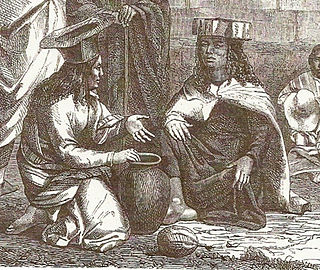
The Atacama people, also called Atacameño, are an Indigenous people from the Atacama Desert and altiplano region in the north of Chile and Argentina and southern Bolivia, mainly the Antofagasta Region.
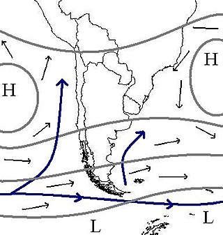
The climate of Chile comprises a wide range of weather conditions across a large geographic scale, extending across 38 degrees in latitude, making generalizations difficult. According to the Köppen system, Chile within its borders hosts at least seven major climatic subtypes, ranging from low desert in the north, to alpine tundra and glaciers in the east and southeast, tropical rainforest in Easter Island, Oceanic in the south and Mediterranean climate in central Chile. There are four seasons in most of the country: summer, autumn, winter, and spring.

Toconao is a village 38 km (24 mi) south of San Pedro de Atacama in the San Pedro de Atacama province of Chile's northern Antofagasta Region. It lies at an elevation of 2,485 m (8,153 ft) above sea level, close to the northeast margin of the Salar de Atacama.

Since the mid-1990s, tourism in Chile has become one of the main sources of income for the country, especially in its most extreme areas. In 2005, this sector grew by 13.6%, generating more than US$500 million, equivalent to 1.33% of the national GDP.

The Atacama Desert is a desert plateau located on the Pacific coast of South America, in the north of Chile. Stretching over a 1,600-kilometre-long (1,000-mile) strip of land west of the Andes Mountains, it covers an area of 105,000 km2 (41,000 sq mi), which increases to 128,000 km2 (49,000 sq mi) if the barren lower slopes of the Andes are included.

The following is an alphabetical list of articles related to the Republic of Chile.

The Paso de Jama is a mountain pass through the Andes between Chile and Argentina, at an elevation of 4,200 m (13,800 ft) at the border. It is the northernmost road border crossing between the two countries. The pass is reached via Chile Route 27 and via National Route 52 (Argentina). The Chile Route 27 reaches an altitude according to OpenStreetMap of 4,831 metres (15,850 ft) at 23°04′21″S67°30′17″W in a road distance of 57.6 kilometres (35.8 mi) west of the border, making it one of the highest highways in South America.
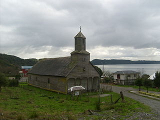
The Church of Detif — Spanish: Iglesia de Detif— is a Catholic church located in the town of Detif, commune of Puqueldón, on Lemuy Island, Chiloé Archipelago, southern Chile.
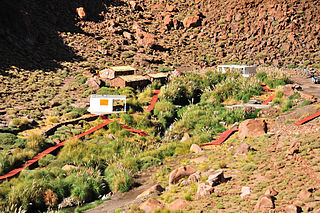
Puritama Hot Springs is a series of eight large pools of geothermal spring water located at the bottom of a canyon in the Atacama Desert, in the Antofagasta Region in the north of Chile. It is located at an altitude of 3,475 meters above sea level, 30 km northeast of the town and commune of San Pedro de Atacama and 348 km northeast of Antofagasta, and is a popular tourist attraction.

Sairecabur is a volcano located on the frontier between Bolivia and Chile. It is part of the Andean Central Volcanic Zone. Sairecabur proper is 5,971 m (19,590 ft) high; other mountains in the range are 5,722 m (18,773 ft) high Curiquinca, 5,819 m (19,091 ft) high Escalante and 5,748 m (18,858 ft) high Cerro Colorado, all of which have erupted a number of lava flows. Also in close proximity to Sairecabur lie the volcanic centres Licancabur, Putana and Juriques.

Chilean expansionism refers to the foreign policy of Chile to expand its territorial control over key strategic locations and economic resources as a means to ensure its national security and assert its power in South America. Chile's significant territorial acquisitions, which occurred mostly throughout the 19th century, paved the way for its emergence as a thalassocracy and one of the three most powerful and wealthiest states in South America during the 20th century. It also formed Chile's geopolitical and national identity as a tricontinental state and one of the countries with the longest coastlines in the world.

The Holy Cross Church, also known as the Catholic Church of Hanga Roa, or simply the Hanga Roa Church is a Catholic Church in Te Pito Te Henua Street in the city of Hanga Roa, the capital and greater city of the Easter Island, a Territory of Chile in the Pacific Ocean. The church was established in 1937, its first priest being Father Sebástian Englert.

Barrio Puerto is the area located between the Plaza Wheelright and Plaza Sotomayor in the downtown area of Valparaíso, Chile.
Chilean architecture is influenced by the country's history, religious culture and unique climate. Chile was a former Spanish colony and its architectural style was therefore strongly influenced by Spanish design. Due to the unique geographical environment, Chilean architecture was also designed to accommodate these natural conditions. In particular, Chile's special geologic structure and resultant high incidence of earthquakes and tsunamis have led to Chilean architects becoming quite experienced in the application of structures and materials for earthquake-resistant structures and post-disaster reconstruction.

The Battle of Río Grande was a minor military engagement that took place on 10 September 1879, during the War of the Pacific. A picket of Chilean soldiers and a Bolivian montonera clashed in Rio Grande, around San Pedro de Atacama. Bolivians are defeated, which eliminates local resistance to Chilean occupation in the Litoral Department.

The Iglesia de San Francisco is a Roman Catholic church located in the commune of Calama, El Loa, Antofagasta Region, Chile. Built in c. 1650, it is the oldest church in Chile. It was declared as a National Monument in 1951.

