Sevenoaks is a local government district in west Kent, England. Its council is based in the town of Sevenoaks.

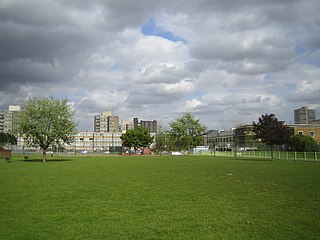
Bartlett Park is a public open space in Poplar in the London Borough of Tower Hamlets in London on Upper North Street. It is located to the south of the Limehouse Cut waterway and the Lansbury Estate to the south and east of the park. The whole landscape is 4.95 hectares.

Chobham is a village and civil parish in the Borough of Surrey Heath in Surrey, England.

Shackleford is a village and civil parish in the Borough of Guildford, Surrey, England centred to the west of the A3 between Guildford and Petersfield 32 miles (51 km) southwest of London and 5.2 miles (8.4 km) southwest of Guildford. Shackleford includes the localities of Eashing, Hurtmore, Norney and Gatwick.

The Lower Lea Valley is the southern end of the Lea Valley which surrounds the River Lea. It is part of the Thames Gateway redevelopment area and was the location of the 2012 Summer Olympics.

Charlwood is a village and civil parish in the Mole Valley district of Surrey, England. It is immediately northwest of London Gatwick Airport in West Sussex, close west of Horley and north of Crawley. The historic county boundary between Surrey and Sussex ran to the south of Gatwick Airport. Boundaries were reformed in 1974 so that the county boundary between Surrey and West Sussex, delineated by the Sussex Border Path, now runs along the northern perimeter of the airport, and the southern extent of Charlwood.

Surrey Heath is a constituency represented in the House of Commons of the UK Parliament since 2005 by Michael Gove, a Conservative who is the current Secretary of State for Levelling Up, Housing and Communities. The Home counties suburban constituency is in the London commuter belt, on the outskirts of Greater London. Surrey Heath is in the north west of Surrey and borders the counties of Berkshire and Hampshire.

Caterham is a town in the Tandridge District of Surrey, England. The town is administratively divided into two: Caterham on the Hill, and Caterham Valley, which includes the main town centre in the middle of a dry valley but rises to equal heights to the south. The town lies close to the A22, 21 miles from Guildford and 6 miles south of Croydon, in an upper valley cleft into the dip slope of the North Downs. Caterham on the Hill is above the valley to the west.

Windlesham is a village in the Surrey Heath borough of Surrey, England, approximately 25 miles (40 km) south west of central London. Its name derives from the Windle Brook, which runs south of the village into Chobham, and the common suffix 'ham', the Old English word for 'homestead'. The civil parish of Windlesham has a population of 17,000 and includes the neighbouring villages of Bagshot and Lightwater.

St Martha's Hill is a landmark in St Martha in Surrey, England between the town of Guildford and village of Chilworth. It is the 18th highest hill in the county and on the Greensand Ridge, in this case at the closest point to the North Downs, commencing to the immediate north at the Guildown-Merrow Down in the parishes of Guildford and Merrow. The top of the hill provides a semi-panorama of Newland's Corner also in the Surrey Hills AONB. Its church is the main amenity of the small parish extending to the south into the streets of Chilworth, with some medieval stone incorporations from a 12th-century predecessor and is a wedding venue mainly to outside the sparsely populated parish.

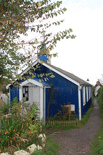
A tin tabernacle, also known as an iron church, is a type of prefabricated ecclesiastical building made from corrugated galvanised iron. They were developed in the mid-19th century initially in the United Kingdom. Corrugated iron was first used for roofing in London in 1829 by civil engineer Henry Robinson Palmer, and the patent was later sold to Richard Walker who advertised "portable buildings for export" in 1832. The technology for producing the corrugated sheets improved, and to prevent corrosion, the sheets were galvanised with a coating of zinc, a process developed by Stanislas Sorel in Paris in the 1830s. After 1850, many types of prefabricated buildings were produced, including churches, chapels and mission halls.

West End is a village and civil parish in Surrey Heath, Surrey, England, approximately 25 miles (40 km) southwest of central London. It is midway between the towns of Camberley and Woking, 4 mi (6.4 km) to the west and east respectively. The River Bourne rises from its sources to the immediate west to run through the village. Until the mid 20th century, the West End consisted of a collection of smallholdings surrounded by a substantial area of common land

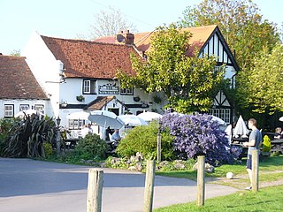
Downside is a small village in the English county of Surrey, in the local government district of Elmbridge, centred on Downside Common which is 18 miles (29 km) southwest of London and 8.4 miles (13.5 km) northeast of Guildford. Most of its buildings form a cluster. It has an inn, Downside Sports and Social Club, regular village hall events and an annual sports day. It is in the Cobham and Downside ward of Elmbridge Borough Council.

The River Bourne is the name given to a Thames tributary in northwest Surrey, England which has a longer tributary, the Windle Brook, that rises nears Bagshot Park in the south of Swinley Forest, Berkshire, merging with it while flowing through villages north of Woking; downstream the Bourne joins the Thames near Weybridge.

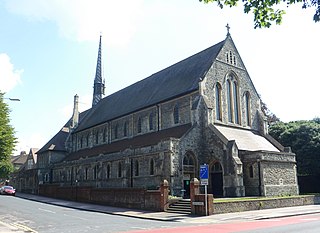
St John the Evangelist's Church is an Anglican church in the Preston Village area of Brighton, in the English city of Brighton and Hove. The Grade II listed building, designed by Sir Arthur Blomfield, was started in 1901 but did not take its present form for another quarter of a century. In the meantime, the nearby parish church of Preston was severely damaged by fire, and the new church was granted the parish church status which it still retains.

St Augustine's Church is a former Anglican church in Brighton, part of the English city of Brighton and Hove. It is close to the Preston Park and Round Hill areas in the central northern part of the city. Built in 1896 and extended in 1914, its parish was extended after a nearby church closed, but in 2003 it was declared redundant itself. The building, which is listed at Grade II in view of its architectural importance, for a few years from 2004 the building was leased by the Elim Pentecostal Church. The Pentecostal congregation made free-standing internal changes to create internal spaces which could be heated in winter, but did not touch the fabric of the building. It is now the St Augustine's Community Arts Centre, encompassing a cafe, exhibition space, offices, and other rooms.

Upper Hale Cemetery is the burial ground for the district of Hale in Farnham in Surrey.
St Margaret was a parish in the ancient borough of Southwark, located south of the River Thames in the Brixton Hundred of Surrey. It was abolished in 1541 during the Dissolution of the Monasteries and replaced with the parish of St Saviour. The parish church was located on what is now Borough High Street and the area now forms part of the London Borough of Southwark. It was from 1444 governed by the Guild of the Assumption of St Margaret's Church.


