Chyorny Mys, Khabarovsk Krai

Last updated

Coordinates: 51°05′48″N138°28′19″E / 51.09667°N 138.47194°E / 51.09667; 138.47194

Geographic coordinate system Coordinate system

A geographic coordinate system is a coordinate system that enables every location on Earth to be specified by a set of numbers, letters or symbols. The coordinates are often chosen such that one of the numbers represents a vertical position and two or three of the numbers represent a horizontal position; alternatively, a geographic position may be expressed in a combined three-dimensional Cartesian vector. A common choice of coordinates is latitude, longitude and elevation. To specify a location on a plane requires a map projection.

Chyorny Mys (Russian :Чёрный Мыс, lit. black cape) is a rural locality (a selo ) in Komsomolsky District of Khabarovsk Krai, Russia. Population: 200 (2011 est.). [1]

Russian language East Slavic language

Russian is an East Slavic language, which is official in the Russian Federation, Belarus, Kazakhstan and Kyrgyzstan, as well as being widely used throughout Eastern Europe, the Baltic states, the Caucasus and Central Asia. It was the de facto language of the Soviet Union until its dissolution on 25 December 1991. Although, nowadays, nearly three decades after the breakup of the Soviet Union, Russian is used in official capacity or in public life in all the post-Soviet nation-states, as well as in Israel and Mongolia, the rise of state-specific varieties of this language tends to be strongly denied in Russia, in line with the Russian World ideology.

The classification system of the types of inhabited localities in Russia, the former Soviet Union, and some other post-Soviet states has certain peculiarities compared with the classification systems in other countries.

Komsomolsky District, Khabarovsk Krai District in Khabarovsk Krai, Russia

Komsomolsky District is an administrative and municipal district (raion), one of the seventeen in Khabarovsk Krai, Russia. It is located in the southern central part of the krai. The area of the district is 25,167 square kilometers (9,717 sq mi). Its administrative center is the city of Komsomolsk-on-Amur. Population: 29,072 (2010 Census); 31,563 (2002 Census); 33,649 (1989 Census).

It is located on the right bank of the Amur River, about 120 kilometers (75 mi) downstream from Komsomolsk-on-Amur. It was the furthest operational point of a branch railway from Selikhino built in the early 1950s by the Soviet Union under Joseph Stalin, intended to link to a tunnel to the island of Sakhalin. Construction of the tunnel was abandoned after Stalin's death; however, the section as far as Chyorny Mys had been completed and was kept open for logging industry traffic until the 1990s.

Amur River river in Russia and China

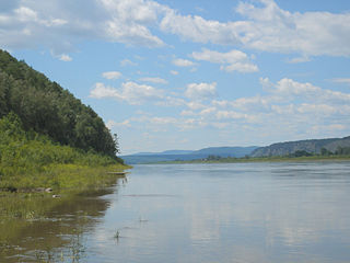
The Amur River or Heilong Jiang is the world's tenth longest river, forming the border between the Russian Far East and Northeastern China. The largest fish species in the Amur is the kaluga, attaining a length as great as 5.6 metres (18 ft). The river basin is home to a variety of large predatory fish such as northern snakehead, Amur pike, taimen, Amur catfish, predatory carp and yellowcheek, as well as the northernmost populations of the Amur softshell turtle and Indian lotus.

Komsomolsk-on-Amur City in Khabarovsk Krai, Russia

Komsomolsk-on-Amur is a city in Khabarovsk Krai, Russia, located on the left bank of the Amur River in the Russian Far East. It is located on the Baikal-Amur Mainline, 356 kilometers (221 mi) northeast of Khabarovsk. As of 2010, it had a population of 263,906 (2010 Census); 281,035 (2002 Census); 315,325 (1989 Census).

Selikhino is a rural locality in Komsomolsky District of Khabarovsk Krai, Russia. Population: 4,255 (2010 Census); 4,865 (2002 Census).

Related Research Articles

Khabarovsk City in Khabarovsk Krai, Russia

Khabarovsk is the largest city and the administrative center of Khabarovsk Krai, Russia, located 30 kilometers (19 mi) from the Chinese border, at the confluence of the Amur and Ussuri Rivers, about 800 kilometers (500 mi) north of Vladivostok. The city was the administrative center of the Far Eastern Federal District of Russia from 2002 until December 2018, when Vladivostok took over that role. It is the second largest city in the Russian Far East, after Vladivostok. As of the 2010 Census, its population was 577,441. It was previously known as Khabarovka. Khabarovsk is the closest major city to Birobidzhan, which is a town and the administrative center of the Jewish Autonomous Oblast.

Khabarovsk Krai First-level administrative division of Russia

Khabarovsk Krai is a federal subject of Russia. It is geographically located in the Far East region of the country and is a part of the Far Eastern Federal District. The administrative center of the krai is the city of Khabarovsk, which is home to roughly half of the krai's population and the second largest city in the Russian Far East. Khabarovsk Krai is the fourth-largest federal subject by area, with a population of 1,343,869 as of the.

Russian Far East Geographic region

The Russian Far East comprises the Russian part of the Far East, the eastermost territory of Russia, between Lake Baikal in Eastern Siberia and the Pacific Ocean.

Far Eastern Federal District Federal district of Russia

The Far Eastern Federal District is the largest of the eight federal districts of Russia but the least populated, with a population of 8,371,257 according to the 2010 Census. The entire federal district lies within the easternmost part of Asia and covers the territory of the Russian Far East. In November 2018, Buryatia and Zabaykalsky Krai were added to the federal district. The seat of the Far Eastern Federal District was moved from Khabarovsk to Vladivostok in December 2018.

Nikolayevsk-on-Amur Town in Khabarovsk Krai, Russia

Nikolayevsk-on-Amur is a town in Khabarovsk Krai, Russia located on the Amur River close to its liman in the Pacific Ocean. Population: 22,752 (2010 Census); 28,492 (2002 Census); 36,296 (1989 Census).

Tom is a river in Russia, the left tributary of the river Zeya. Its length is 433 km. Its source is near the border between Amur Oblast and Khabarovsk Krai. It flows into the Zeya between Svobodny and Blagoveshchensk. The city of Belogorsk lies on the Tom River.

Tayozhny/Tayezhny, Tayozhnaya/Tayezhnaya, or Tayozhnoye/Tayezhnoye is the name of several inhabited localities in Russia.

The Nanai language is spoken by the Nanai people in Siberia, and to a much smaller extent in China's Heilongjiang province, where it is known as Hezhe. The language has about 1,400 speakers out of 17,000 ethnic Nanai, but most are also fluent in Russian or Chinese, and mostly use one of those languages for communication.

Novy Urgal human settlement in Russia

Novy Urgal is an urban locality in Verkhnebureinsky District of Khabarovsk Krai, Russia, located in the valley of the Bureya River, close to its confluence with the Urgal River, about 340 kilometers (210 mi) northwest of the krai's administrative center of Khabarovsk and 28 kilometers (17 mi) west of the district's administrative center of Chegdomyn. Population: 6,803 (2010 Census); 7,274 (2002 Census); 9,126 (1989 Census).

Chegdomyn is an urban locality and the administrative center of Verkhnebureinsky District of Khabarovsk Krai, Russia. Population: 13,048 (2010 Census); 15,303 (2002 Census); 20,347 (1989 Census).

Sakhalin Tunnel railway tunnel

The Sakhalin Tunnel is an incomplete and currently postponed construction project, which after completion would connect the island of Sakhalin with mainland Russia via a tunnel of approximately 10 kilometres (6.2 mi) under the Nevelskoy Strait. On January 16, 2009, it was suggested by the Russian government the link could be completed with a bridge, rather than tunnel.

Nevelskoy Strait strait

The Nevelskoy Strait is a strait between the Khabarovsk Krai mainland and Sakhalin island in Sakhalin Oblast, all of the Russian Far East region in Northeast Asia.

Lazarev (urban-type settlement) Work settlement in Khabarovsk Krai, Russia

Lazarev is an urban-type settlement in the Nikolayevsky District of Khabarovsky Krai, Russia. In 2010 it had 1,307 inhabitants.

Bureinsky Ridge mountain range

Bureinsky Ridge is a ridge in the Khabarovsk Krai in the southern part of the Russian Far East, spanning about 400 km and with a maximum height of 2167m.

Chyorny Mys is the name of several rural localities in Russia:

Khabarovsk Airlines, stylised KhabAvia, is a Russian state-owned airline with bases at Khabarovsk and Nikolayevsk-on-Amur. Established in 2004, the airline operates nine Antonov and Let aircraft as of December 2016. Its flight schedule, accessed in December 2016, states that Khabarovsk Airlines flies to ten destinations.

References