
The geography of France consists of a terrain that is mostly flat plains or gently rolling hills in the north and west and mountainous in the south and the east.
Articles in economics journals are usually classified according to the JEL classification codes, a system originated by the Journal of Economic Literature. The JEL is published quarterly by the American Economic Association (AEA) and contains survey articles and information on recently published books and dissertations. The AEA maintains EconLit, a searchable data base of citations for articles, books, reviews, dissertations, and working papers classified by JEL codes for the years from 1969. A recent addition to EconLit is indexing of economics-journal articles from 1886 to 1968 parallel to the print series Index of Economic Articles.

The European route E 22 is one of the longest European routes. It has a length of about 5,320 km (3,310 mi). Many of the E-roads have been extended into Asia since the year 2000; the E 22 was extended on 24 June 2002.
Shuswap Lake Marine Provincial Park is an 896-hectare provincial park in British Columbia, Canada, comprising 991 ha. The Park has a variety of amenities including boat launch ramps, picnic areas, and 27 campsites around the perimeter of Shuswap Lake. The lake's name and that of the surrounding Shuswap Country is from the Shuswap people (Secwepemc), the most northern of the Salishan speaking people.

Ramjibanpur is a city and a municipality in Paschim Medinipur district in the Indian state of West Bengal.

SM U-27 was a German Type U-27 U-boat built for service in the Imperial German Navy. She was launched on 14 July 1913, and commissioned on 8 May 1914 with Kapitänleutnant Bernd Wegener in command.

Advanced Landing Grounds (ALGs) were temporary advance airfields constructed by the Allies during World War II during the liberation of Europe. They were built in the UK prior to the invasion and thereafter in northwest Europe from 6 June 1944 to V-E Day, 7 May 1945.

Dobrești is a commune in Bihor County, northwestern Romania with a population of 5,260 people (2011). It is composed of eight villages: Cornișești (Nagykerpesd), Crâncești (Karáncsfalva), Dobrești, Hidișel (Nánhegyes), Luncasprie (Lankás), Răcaș (Lankástanya), Topa de Jos (Alsótopa) and Topa de Sus (Felsőtopa).

Zakłodzie is a village in the administrative district of Gmina Radecznica, within Zamość County, Lublin Voivodeship, in eastern Poland. It lies approximately 3 kilometres (2 mi) north-east of Radecznica, 30 km (19 mi) west of Zamość, and 57 km (35 mi) south of the regional capital Lublin.

Tú Trĩ is a commune (xã) and village in Bạch Thông District, Bắc Kạn Province, in Vietnam.
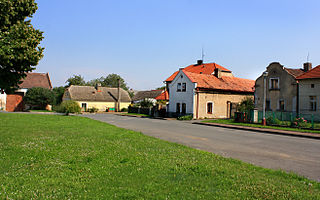
Jizerní Vtelno is a village and municipality in Mladá Boleslav District in the Central Bohemian Region of the Czech Republic. It is located 6 kilometres (3.7 mi) southwest of Mladá Boleslav and 44 kilometres (27 mi) northeast of Prague.
Youhao (help·info) District is a district of the prefecture-level city of Yichun, Heilongjiang province, China.

Maryon Wilson Park is a public park on Thorntree Road, Charlton, in the Royal Borough of Greenwich. Together with the neighbouring Maryon Park and Gilbert's Pit, it is a Local Nature Reserve.
Rava is a village in Järva Parish, Järva County in northern-central Estonia.
110-Morgen is a neighborhood of Rotterdam, Netherlands.
De Esch is a neighborhood of Rotterdam, Netherlands.
During the British Raj period, Lakhtar State, in the present-day Indian state of Gujarat, was a non-salute princely state and was governed by members of a Jhala dynasty.


