
Mount Vesuvius is a somma–stratovolcano located on the Gulf of Naples in Campania, Italy, about 9 km (5.6 mi) east of Naples and a short distance from the shore. It is one of several volcanoes forming the Campanian volcanic arc. Vesuvius consists of a large cone partially encircled by the steep rim of a summit caldera, resulting from the collapse of an earlier, much higher structure.

A stratovolcano, also known as a composite volcano, is a conical volcano built up by many layers (strata) of hardened lava and tephra. Unlike shield volcanoes, stratovolcanoes are characterized by a steep profile with a summit crater and periodic intervals of explosive eruptions and effusive eruptions, although some have collapsed summit craters called calderas. The lava flowing from stratovolcanoes typically cools and solidifies before spreading far, due to high viscosity. The magma forming this lava is often felsic, having high to intermediate levels of silica, with lesser amounts of less viscous mafic magma. Extensive felsic lava flows are uncommon, but have traveled as far as 15 km (9 mi).

The Lassen volcanic area presents a geological record of sedimentation and volcanic activity in and around Lassen Volcanic National Park in Northern California, U.S. The park is located in the southernmost part of the Cascade Mountain Range in the Pacific Northwest region of the United States. Pacific Oceanic tectonic plates have plunged below the North American Plate in this part of North America for hundreds of millions of years. Heat and molten rock from these subducting plates has fed scores of volcanoes in California, Oregon, Washington and British Columbia over at least the past 30 million years, including these in the Lassen volcanic areas.

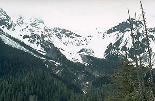
Lassen Peak, commonly referred to as Mount Lassen, is a 10,457 ft (3,187 m) lava dome volcano in Lassen Volcanic National Park in Northern California. Located in the Shasta Cascade region above the northern Sacramento Valley, it is the southernmost active volcano in the Cascade Range of the Western United States, and part of the Cascade Volcanic Arc stretching from southwestern British Columbia to northern California. It supports many flora and fauna among its diverse habitats, which reach high elevations and are subject to frequent snowfall.

Mount Unzen is an active volcanic group of several overlapping stratovolcanoes, near the city of Shimabara, Nagasaki on the island of Kyushu, Japan's southernmost main island.

Laetoli is a pre-historic site located in Enduleni ward of Ngorongoro District in Arusha Region, Tanzania. The site is dated to the Plio-Pleistocene and famous for its Hominina footprints, preserved in volcanic ash. The site of the Laetoli footprints is located 45 km south of Olduvai gorge. The location and tracks were discovered by archaeologist Mary Leakey and her team in 1976, and were excavated by 1978. Based on analysis of the footfall impressions "The Laetoli Footprints" provided convincing evidence for the theory of bipedalism in Pliocene Hominina and received significant recognition by scientists and the public. Since 1998, paleontological expeditions have continued under the leadership of Amandus Kwekason of the National Museum of Tanzania and Terry Harrison of New York University, leading to the recovery of more than a dozen new Hominina finds, as well as a comprehensive reconstruction of the paleoecology. The site is a registered National Historic Sites of Tanzania.

Lascar is a stratovolcano in Chile within the Central Volcanic Zone of the Andes, a volcanic arc that spans Peru, Bolivia, Argentina and Chile. It is the most active volcano in the region, with records of eruptions going back to 1848. It is composed of two separate cones with several summit craters. The westernmost crater of the eastern cone is presently active. Volcanic activity is characterized by constant release of volcanic gas and occasional vulcanian eruptions.

A fossil track or ichnite is a fossilized footprint. This is a type of trace fossil. A fossil trackway is a sequence of fossil tracks left by a single organism. Over the years, many ichnites have been found, around the world, giving important clues about the behaviour of the animals that made them. For instance, multiple ichnites of a single species, close together, suggest 'herd' or 'pack' behaviour of that species.

Footprints are the impressions or images left behind by a person walking or running. Hoofprints and pawprints are those left by animals with hooves or paws rather than feet, while "shoeprints" is the specific term for prints made by shoes. They may either be indentations in the ground or something placed onto the surface that was stuck to the bottom of the foot. A "trackway" is a set of footprints in soft earth left by a life-form; animal tracks are the footprints, hoofprints, or pawprints of an animal.

Ampato is a dormant 6,288-metre (20,630 ft) stratovolcano in the Andes of southern Peru. It lies about 70–75 kilometres (43–47 mi) northwest of Arequipa and is part of a north-south chain that includes the volcanoes Hualca Hualca and Sabancaya, the last of which has been historically active.

Taapaca is a Holocene volcanic complex in northern Chile's Arica y Parinacota Region. Located in the Chilean Andes, it is part of the Central Volcanic Zone of the Andean Volcanic Belt, one of four distinct volcanic chains in South America. The town of Putre lies at the southwestern foot of the volcano.

The Canadian Cascade Arc, also called the Canadian Cascades, is the Canadian segment of the North American Cascade Volcanic Arc. Located entirely within the Canadian province of British Columbia, it extends from the Cascade Mountains in the south to the Coast Mountains in the north. Specifically, the southern end of the Canadian Cascades begin at the Canada–United States border. However, the specific boundaries of the northern end are not precisely known and the geology in this part of the volcanic arc is poorly understood. It is widely accepted by geologists that the Canadian Cascade Arc extends through the Pacific Ranges of the Coast Mountains. However, others have expressed concern that the volcanic arc possibly extends further north into the Kitimat Ranges, another subdivision of the Coast Mountains, and even as far north as Haida Gwaii.
Calabozos is a Holocene caldera in central Chile's Maule Region. Part of the Chilean Andes' volcanic segment, it is considered a member of the Southern Volcanic Zone (SVZ), one of the three distinct volcanic belts of South America. This most active section of the Andes runs along central Chile's western edge, and includes more than 70 of Chile's stratovolcanoes and volcanic fields. Calabozos lies in an extremely remote area of poorly glaciated mountains.
The Bridge River Vent is a volcanic crater in the Pacific Ranges of the Coast Mountains in southwestern British Columbia, Canada. It is located 51 km (32 mi) west of Bralorne on the northeastern flank of the Mount Meager massif. With an elevation of 1,524 m (5,000 ft), it lies on the steep northern face of Plinth Peak, a 2,677 m (8,783 ft) high volcanic peak comprising the northern portion of Meager. The vent rises above the western shoulder of the Pemberton Valley and represents the northernmost volcanic feature of the Mount Meager massif.

Yucamane, Yucamani or Yucumane is an andesitic stratovolcano in the Tacna Region of southern Peru. It is part of the Peruvian segment of the Central Volcanic Zone, one of the three volcanic belts of the Andes generated by the subduction of the Nazca plate beneath the South America plate. Peru's active volcanoes Ubinas, Sabancaya and El Misti are also part of the Central Volcanic Zone.

The Volcano of Roccamonfina is an extinct volcano in Roccamonfina, Campania, southern Italy. It was active from some 650,000 to 50,000 years ago. It comprises an isolated large cone of some 25 km (16 mi) perimeter between the Monti Aurunci, the plain and valley of the Garigliano, the Monte Massico and the Monti Trebulani. The central caldera has a diameter of nearly 6 km (4 mi) and the small commune (town) of Roccamonfina is located inside it. Volcanic activity is now replaced by minor seismic movements and by the presence of mineral waters. The mount is part of the Roccamonfina-Garigliano Mouth Regional Park, created in 1999.
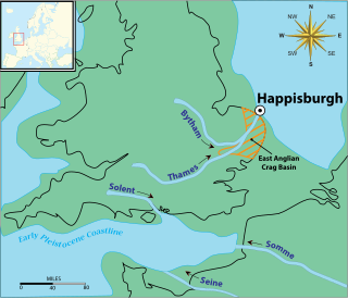
The Happisburgh footprints were a set of fossilized hominid footprints that date to the end of the Early Pleistocene, around 950–850,000 years ago. They were discovered in May 2013 in a newly uncovered sediment layer of the Cromer Forest Bed on a beach at Happisburgh in Norfolk, England, and carefully photographed in 3D before being destroyed by the tide shortly afterwards.

Deriba is a Pleistocene or Holocene caldera in Darfur, Sudan. Part of the volcanoes of the Marra Mountains, it lies on the Darfur dome and like the Tagabo Hills and Meidob Hills volcanism may be the product of a mantle plume. After the separation of South Sudan, the highest point of Sudan is on the margin of the caldera.

Mount Cayley is an eroded but potentially active stratovolcano in the Pacific Ranges of southwestern British Columbia, Canada. Located 45 km (28 mi) north of Squamish and 24 km (15 mi) west of Whistler, the volcano resides on the edge of the Powder Mountain Icefield. It consists of massif that towers over the Cheakamus and Squamish river valleys. All major summits have elevations greater than 2,000 m (6,600 ft), Mount Cayley being the highest at 2,385 m (7,825 ft). The surrounding area has been inhabited by indigenous peoples for more than 7,000 years while geothermal exploration has taken place there for the last four decades.

Chachani is a volcanic group in southern Peru, 22 kilometres (14 mi) northwest of the city of Arequipa. Part of the Central Volcanic Zone of the Andes, it is 6,057 metres (19,872 ft) above sea level. It consists of several lava domes and individual volcanoes such as Nocarane, along with lava shields such as the Airport Domes. Underneath Chachani lies a caldera.

