
Vail is a census-designated place (CDP) in Pima County, Arizona, United States. It is twenty-four miles southeast of Tucson. The population was 10,208 at the 2010 census, up from 588 in the 2000 census. The area is known for the nearby Colossal Cave, a large cave system, and the Rincon Mountains District of Saguaro National Park, a top tourism spot within Arizona.

The Santa Rita Mountains, located about 65 km (40 mi) southeast of Tucson, Arizona, extend 42 km (26 mi) from north to south, then trending southeast. They merge again southeastwards into the Patagonia Mountains, trending northwest by southeast. The highest point in the range, and the highest point in the Tucson area, is Mount Wrightson, with an elevation of 9,453 feet, The range contains Madera Canyon, one of the world's premier birding areas. The Smithsonian Institution's Fred Lawrence Whipple Observatory is located on Mount Hopkins. The range is one of the Madrean sky islands.
The Coronado National Forest is a United States National Forest that includes an area of about 1.78 million acres (7,200 km2) spread throughout mountain ranges in southeastern Arizona and southwestern New Mexico.

The Santa Catalina Mountains, commonly referred to as the Catalina Mountains or the Catalinas, are north and northeast of Tucson in Arizona, United States, on Tucson's north perimeter. The mountain range is the most prominent in the Tucson area, with the highest average elevation. The highest point in the Catalinas is Mount Lemmon at an elevation of 9,157 feet (2,791 m) above sea level and receives 180 inches (460 cm) of snow annually.

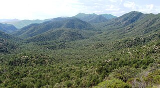
The Rincon Mountains are a significant mountain range east of Tucson, Pima County, Arizona, in the United States. The Rincon Mountains are one of five mountain ranges surrounding the Tucson valley. The other ranges include the most prominent, the Santa Catalina Mountains to the north, the Santa Rita Mountains to the south, the Tucson Mountains to the west, and the Tortolita Mountains to the northwest. Redington Pass separates the Rincon Mountains from the Santa Catalina Mountains. The Rincon Mountains are generally less rugged than the Santa Catalina Mountains and Santa Rita Mountains. The Rincon Mountains are also included in the Madrean sky island mountain ranges of southeast Arizona, extreme southwest New Mexico, and northern Sonora Mexico.

The Santa Cruz River is a tributary river to the Gila River in Southern Arizona and northern Sonora, Mexico. It is approximately 184 miles (296 km) long.

Sonorella is a genus of land snails in the family Helminthoglyptidae. They are known commonly as talussnails or talus snails because most live in talus and similar habitat. They are distributed across the southwestern United States and adjacentMexico. There are about 80 species.
The San Rafael Valley is a high intermontane grass valley in eastern Santa Cruz County, Arizona. The valley is bounded to the west by the Patagonia Mountains, to the north and northeast by the Canelo Hills and to the east by the Huachuca Mountains in Cochise County. The valley forms the headwaters of the Santa Cruz River which flows south into Sonora, Mexico just east of the historic Lochiel townsite.

The Las Cienegas National Conservation Area is a National Conservation Area of Arizona, located in the transitional zone between the Sonoran Desert and the Chihuahuan Desert.

The Patagonia Mountains are a 15-mile-long (24 km) mountain range within the Coronado National Forest, and in Santa Cruz County, Arizona, United States.

The Canelo Hills are a range of low mountains or hills in eastern Santa Cruz County, Arizona. The range consists of a series of northwest–southeast trending ridges extending from the Sonoita Creek valley southwest of Sonoita to the Parker Canyon Lake area in southwest Cochise County, Arizona. The Canelo Hills merge with the Huachuca Mountains to the southeast. The San Rafael Valley lies to the southwest of the range and the Patagonia Mountains lie to the west across the Harshaw Creek valley. The Canelo Hills Cienega Reserve and the ghost town of Canelo, Arizona, are located on the eastern side of the hills.

The Little Rincon Mountains are a small range of mountains, lying to the east of the Rincon Mountains, at Tucson, of eastern Pima County, Arizona. The range is located in northwest Cochise County and is part of the western border of the San Pedro River and Valley, the major valley and river of western Cochise County. The river is northward flowing to meet the Gila River; its headwaters are south of the US-Mexico border in northern Sonora. A small part of the Little Rincon range's southwest lies in Pima County.

Empire Ranch is a working cattle ranch in southeastern Pima County, Arizona, that was placed on the National Register of Historic Places in 1976. In its heyday, Empire Ranch was one of the largest in Arizona, with a range spanning over 180 square miles, and its owner, Walter L. Vail, was an important figure in the establishment of southern Arizona's cattle industry.

Ciénega Creek is an intermittent stream located in the Basin and Range region of southern Arizona, and is one of the most intact riparian corridors left in the state. It originates in the Canelo Hills and continues northwest about 50 miles (80 km) to an area just outside Tucson, where it becomes known as Pantano Wash. Pantano Wash continues through Tucson and eventually connects with the Rillito River.

Pantano is a Ghost town located in eastern Pima County, Arizona, between Benson and Vail. Access is via the Marsh Station Road interchange on I-10. It was originally a mail and stagecoach stop named Ciénega Station, after the nearby Ciénega Creek, and later grew into a small railroad town with the arrival of the Southern Pacific in 1880.

The Babocomari River is a major tributary of the upper San Pedro River in southeastern Arizona. The river begins in the Sonoita Basin near the community of Elgin, Arizona, and flows eastward for approximately 25 miles (40 km) before merging with the San Pedro, just south of the Fairbank Historic Townsite in the San Pedro Riparian National Conservation Area. The Babocomari drains an area of about 310 square miles (800 km2), including the northern Huachuca Mountains, the northwestern Canelo Hills, and the southern Mustang Mountains, and is one of three drainages of the Sonoita Basin, the other two being Sonoita Creek and Cienega Creek. Vegetation consists of riparian trees along the main channel and small marshy grasslands.

Arivaca Creek is a small valley stream in southern Pima County, Arizona, that is approximately 5.5 miles (8.9 km) long from its origin in Arivaca Valley to its confluence with the Brawley Wash stream system. As a seasonal stream, Arivaca Creek is perennial for only about two miles most years and experiences its greatest stream-flow during winter and the summer Monsoon season.

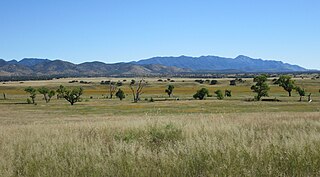
 Cienega Valley, with the Whetstones and the Mustang Mountains in the background.
 A pronghorn antelope in the Cienega Valley.
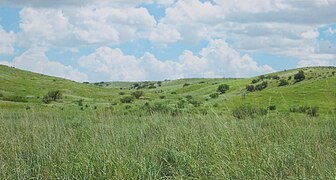 Prairie, green after the summer monsoon.
 A cottonwood tree along Cienega Creek.


