
Magasa is a town and comune in the province of Brescia, in Lombardy in northern Italy.

The Luigi Broglio Space Center (BSC) is an Italian-owned spaceport near Malindi, Kenya, named after its founder and Italian space pioneer Luigi Broglio. Developed in the 1960s through a partnership between the Sapienza University of Rome's Aerospace Research Centre and NASA, the BSC served as a spaceport for the launch of both Italian and international satellites (1967–1988). The center comprises a main offshore launch site, known as the San Marco platform, as well as two secondary control platforms and a communications ground station on the mainland.

The Tre Cime di Lavaredo, also called the Drei Zinnen, are three distinctive battlement-like peaks, in the Sexten Dolomites of northeastern Italy. They are probably one of the best-known mountain groups in the Alps. The three peaks, from east to west, are:
The Cima dell'Uomo is a mountain of the Swiss Lepontine Alps, located north-west of Monte Carasso in the canton of Ticino. It lies east of the slightly higher Pizzo di Vogorno, near the southern end of the range separating the main valley of the Ticino from Valle Verzasca.

The Cima della Bondasca or Pizzo del Ferro centrale is a mountain in the Bregaglia Range (Alps), located on the border between Italy and Switzerland. Its summit is the triple watershed between Valle del Ferro (Italy), Val Bondasca and Val d'Albigna (Switzerland).

The Cima Verosso is a mountain of the Pennine Alps, located west of Bognanco in the Italian region of Piedmont. It lies on the range east of the Portjengrat between the Val Divedro and the Valle di Bognanco. Its summit lies just east of the watershed and border with the Swiss canton of Valais.
The Cima del Rosso is a mountain of Pennine Alps, located on the border between Switzerland and Italy. It lies between the Val Divedro (Valais) and the Valle di Bognanco (Piedmont), east of the Portjengrat.
Pizzo delle Pecore is a mountain of the Swiss Lepontine Alps, located east of Cevio in the canton of Ticino. It lies just south of the slightly higher Cima di Broglio, on the range between the Valle Maggia and the Valle Verzasca.
The Poncione Piancascia is a mountain of the Swiss Lepontine Alps, overlooking Brione in the canton of Ticino. It lies between the Valle Maggia and the Valle Verzasca. The Poncione di Piancascia has an elevation of 2,360 metres and is the highest summit on the range south of Pizzo delle Pecore.
Cima di Pinadee is a mountain of the Swiss Lepontine Alps, located east of Olivone in the canton of Ticino. It lies between the Valle di Blenio and the Val di Carassino, north of the Passo di Piotta.

The Pala group is the largest massif of the Dolomites, with about 240 km² of surface, located between eastern Trentino and Veneto, in the area between Primiero, Valle del Biois and Agordino.

The Valle Germanasca is a valley in the Metropolitan City of Turin, Piedmont, north-western Italy run by the Germanasca stream, a right affluent of the Chisone.
The Concarena is a mountain in Lombardy, northern Italy. It is multi summited and its highest peak is the Cima della Bacchetta, with a height of 2,549 m.

Monte Bo is a mountain in the Alpi Biellesi, a sub-range of Pennine Alps.
The Corno di Gesero is a mountain of the Lepontine Alps, located on the border between the Swiss cantons of Ticino and Graubünden. It lies on the range west of the Cima di Cugn, between the Valle d'Arbedo and the Val Traversagna.

The Stura di Demonte Valley is a valley in south-west of Piedmont in the Province of Cuneo, Italy.

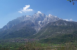
The Garda Mountains, occasionally also the Garda Hills, are an extensive mountain range of the Southern Limestone Alps in northern Italy.

Val Grande National Park is a protected area located in Piedmont, in the north of Italy, at the border with Switzerland. It is most notable for landscapes of the High Alps.
Team Colpack–Ballan is an Italian cycling team based in Bergamo, Italy.
The Natural Park of Marguareis(in Italian Parco Naturale del Marguareis) is a regional natural park of the Ligurian Alps located in the Province of Cuneo.
