
Magasa is a town and comune in the province of Brescia, in Lombardy in northern Italy.

Giovanni Battista Cima, also called Cima da Conegliano, was an Italian Renaissance painter, who mostly worked in Venice. He can be considered part of the Venetian school, though he was also influenced by Antonello da Messina, in the emphasis he gives to landscape backgrounds and the tranquil atmosphere of his works. Once formed his style did not change greatly. He mostly painted religious subjects, often on a small scale for homes rather than churches, but also a few, mostly small, mythological ones.

Conegliano is a town and comune of the Veneto region, Italy, in the province of Treviso, about 30 kilometres (19 mi) north by rail from the town of Treviso. The population of the city is of 35,023 people. The remains of a 10th-century castle are situated on a hill that dominates the town. Formerly belonging to the Bishop of Vittorio Veneto, what remains is a bell tower, which now houses a small museum, and outer walls.

The Tre Cime di Lavaredo, also called the Drei Zinnen ; pronounced [ˌdʁaɪ ˈtsɪnən](listen)), are three distinctive battlement-like peaks, in the Sexten Dolomites of northeastern Italy. They are probably one of the best-known mountain groups in the Alps. The three peaks, from east to west, are:
Bianca Lancia d'Agliano, was an Italian noblewoman. She was the mistress and later, possibly the last wife of the Hohenstaufen emperor Frederick II. The marriage was conducted while she was on her deathbed, therefore it was considered non-canonical.
The 1949 Giro d'Italia was the 32nd Giro d'Italia, organized and sponsored by the newspaper La Gazzetta dello Sport. The race began on 21 May in Palermo with a stage that stretched 261 km (162 mi) to Catania, finishing in Monza on 12 June after a 267 km (166 mi) stage and a total distance covered of 4,088 km (2,540 mi). The race was won by Fausto Coppi of the Bianchi team, with fellow Italians Gino Bartali and Giordano Cottur coming in second and third respectively.

Cima di Castello is a mountain of the Bregaglia Range, located on the border between Italy and Switzerland. With a height of 3,379 metres (11,086 ft) above sea level, it is the second highest mountain in the Bregaglia Range. Its summit lies between the valleys of the Albigna and Forno Glacier and the valley of Val Mello.

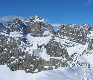
Cristallo is a mountain massif in the Italian Dolomites, northeast of Cortina d'Ampezzo, in the province of Belluno, Veneto, northern Italy. It is a long, indented ridge with four summits higher than 3,000 metres. The mountain range is part of the "Natural Park of the Ampezzo Dolomites".

Monte Baldo is a mountain range in the Italian Alps, located in the provinces of Trento and Verona. Its ridge spans mainly northeast-southwest, and is bounded from south by the highland ending at Caprino Veronese, from west by Lake Garda, from north by the valley joining Rovereto to Nago-Torbole and, from east, the Val d'Adige.
Cima di Bri is a mountain in the Lepontine Alps, located in the Swiss canton of Ticino. It is situated between Lavertezzo and Biasca, on the range that separates the valleys of Verzasca and Leventina. With an altitude of 2,520 metres, it is the highest summit of this chain south of Passo di Gagnone.
The Cima Bianca is a mountain of the Lepontine Alps, overlooking Giornico in the canton of Ticino. On the northern side lies a small lake named Laghetto.
The Cima della Bianca is a mountain of the Lepontine Alps and located on the border between the cantons of Ticino and Graubünden. It is in Switzerland and lies east of the Scopi.
Cima di Piancabella is a mountain of the Swiss Lepontine Alps, overlooking Malvaglia in the canton of Ticino. It is located south of the Cima di Gana Bianca.

The Pala group is the largest massif of the Dolomites, with about 240 km² of surface, located between eastern Trentino and Veneto, in the area between Primiero, Valle del Biois and Agordino.

The Cima Ekar Observing Station is an astronomical observatory on the crest of Cima Ekar, a mountain ridge located approximately 4 kilometers southeast of and 350 m higher than the town of Asiago, Italy.

The Garda Mountains, occasionally also the Garda Hills, are an extensive mountain range of the Southern Limestone Alps in northern Italy.
Cima Brenta is the highest mountain in the Brenta group, a subgroup of the Rhaetian Alps in the Italian Region of Trentino-Alto Adige, with a reported height of 3,150 metres (10,330 ft). The mountain rises imposingly up between the rock towers and pinnacles of the central Brenta Group. A sharp ridge connects the mountain on its southern side to the Spallone die Massodi. The northern ridge steeply descends towards Bocca del Tuckett. Towards north west a slender couloir descends all the way from the top towards the Vedretta di Brenta Inferiore, the mountain's 'lower' glacier. Large shouldering formations extend towards the west, culminating in the Cima Mandrone and the Punti di Campiglio, and northwest, culminating in the Cima Massari. Above these formations a glacier, the Vedretta di Brenta Superiore, the 'upper' glacier descends the mountain, being cut off by a vertical precipice over the Vedretta di Brenta Inferiore. On the eastern side the mountain rises up with an imposing 700-meter high vertical rock face with on its left side a distinct orange-like color. Above this lies a horizontal ledge, the Cengia Garbari, on which the Via delle Bocchette Alte proceeds. The actual mountain has two summits that are some 250 meters apart, of which the eastern top reaches the highest altitude. The glaciers, vedrette, have been shrinking steadily over the last decades as a result of climate change. The historical name Cima Brenta was not always as evident as it is today. The toponymy of these parts was largely established by Nepomuceno Bolognini. The mountain, somehow, became a place where nationalistic sentiments were demonstrated. In 1889 the Austro-Hungarian authorities decided to rename the mountain to Kaiser Franz Josef-Spitze. The name never caught on -not even in German literature. When the occasion occurred to raise a large yellow-black imperial flag on the summit, fully visible from Val Rendena as well as from Molveno, local guide Giuseppe 'Bepaccia' Zeni and some companions climbed the mountain to take it down. In 1912, on the other hand, the Italian flag was hoisted by irredentists on Cima Brenta, deliberately just before the first snow fall, so that the flag remained visible until the next summer. Around 1953 electricity company SISM, predecessor of ENEL proposed to build a cable car trajectory from Molveno to the top of Cima Brenta. The plans were abandoned and in 1967 the mountain became protected as part of the Parco Naturale Adamello-Brenta.

O Outro Lado do Paraíso is a Brazilian telenovela created by Walcyr Carrasco, which premiered on TV Globo on 23 October 2017, replacing A Força do Querer, and ended on 11 May 2018, being replaced by Segundo Sol.

Bianca Pinheiro is a Brazilian comics artist and illustrator. She graduated from Graphic Arts by UTFPR and did postgraduate studies in Comics by the Grupo Educacional Opet.
