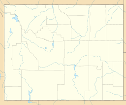
Mount Moran is a mountain in Grand Teton National Park of western Wyoming, USA. The mountain is named for Thomas Moran, an American western frontier landscape artist. Mount Moran dominates the northern section of the Teton Range rising 6,000 feet (1,800 m) above Jackson Lake. Several active glaciers exist on the mountain with Skillet Glacier plainly visible on the monolithic east face. Like the Middle Teton in the same range, Mount Moran's face is marked by a distinctive basalt intrusion known as the Black Dike.
Doane Peak is in the northern Teton Range, Grand Teton National Park, Wyoming. The peak is located west of and across Jackson Lake from Colter Bay Village. The scenic Waterfalls Canyon is immediately northeast of the peak, but there are no maintained trails in the area. Access to the summit involves off trail hiking and scrambling as the top of the mountain is more than 4,500 feet (1,400 m) above Jackson Lake. The peak is named for Lt. Gustavus Cheyney Doane.
Raynolds Peak is in the northern Teton Range, Grand Teton National Park, Wyoming. The mountain rises to the north of Moran Canyon and has numerous deep cirques on its north face above Snowshoe Canyon. There are no maintained trails in the region and the summit is 5 miles (8 km) west of Moran Bay on Jackson Lake. The peak is named after William F. Raynolds who was in charge of the 1859-1860 Raynolds Expedition to the region.

Mount Woodring is located in the Teton Range, Grand Teton National Park, Wyoming. The mountain is immediately west of Leigh Lake and is sandwiched between Paintbrush Canyon to the south and Leigh Canyon to the north. The best access to the summit is from Paintbrush Divide along the Paintbrush Canyon Trail.

Symmetry Spire is located in the Teton Range, Grand Teton National Park in the U.S. state of Wyoming. The mountain, first climbed via the east ridge route on August 20, 1929, by Fritiof Fryxell and Phil Smith, towers above the northwest shore of Jenny Lake and Cascade Canyon. The scenic Lake of the Crags, a cirque lake or tarn, is located northwest of the summit and is accessed by way of Hanging Canyon. Popular with mountaineers, the spire has numerous challenging cliffs.
Teepe Pillar is located in the Teton Range, Grand Teton National Park, Wyoming, immediately south of Grand Teton. The peak is the seventh highest in the Teton Range. Teepe Pillar is separated from Grand Teton by a col which drops sharply to the east and west. Northeast of and well below the summit, the Teepe Glacier is situated in a cirque. From Jackson Hole, Teepe Pillar is difficult to observe except from the northeast as it is hidden from view by Disappointment Peak.
Maidenform Peak (11,142 feet is located in the Teton Range, Grand Teton National Park in the U.S. state of Wyoming. Maidenform Peak is at the head of Leigh Canyon and .64 miles SSW of Cleaver Peak. Cirque Lake is immediately east of the peak.
Rock of Ages is located in the Teton Range, Grand Teton National Park in the U.S. state of Wyoming. Rock of Ages is .50 miles (0.80 km) ESE of The Jaw and on the south side of Hanging Canyon.

Mount Hunt (10,788 feet is located in the Teton Range, Grand Teton National Park in the U.S. state of Wyoming. The peak is situated near the head of Open Canyon and just west of Mount Hunt Divide. The peak was named after William Price Hunt, one of the leaders of the 1811-12 Astor Expedition.
Dudley Lake is located in Grand Teton National Park, in the US state of Wyoming.
Grizzly Bear Lake is located in Grand Teton National Park, in the U. S. state of Wyoming. Grizzly Bear Lake is situated to the south of Leigh Canyon and is .75 miles (1.21 km) west of Mount Woodring. The lake is not on a designated trail and is in a less frequented section of Grand Teton National Park. The easiest access to the lake is from the Paintbrush Canyon Trail descending from above a low saddle at a point west of there at approximately the 10,160 feet (3,100 m) elevation, where the slopes to the north down to the lake are easiest.
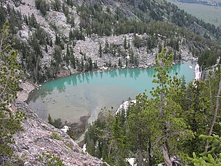
Delta Lake is located in Grand Teton National Park, in the U.S. state of Wyoming. Delta Lake is situated in Glacier Gulch and is fed rock flour from the Teton Glacier, which turns the water turquoise in appearance. It has been an increasingly popular hiking destination in the park, with the number of hikers increasing 164% from 2016 to 2018. The easiest walk to the lake is by way of the a hike commencing from the Lupine Meadows trailhead. Following the trail to Surprise and Amphitheater Lakes and an off trail effort to the north from Surprise Lake provides access to Delta Lake. The effort is considered strenuous for even getting to Surprise Lake is nearly a ten mile roundtrip with over 3,000 feet (910 m) of elevation gain. Below Delta Lake lies Glacier Falls, an intermittent 300-foot (91 m) waterfall.
Snowdrift Lake is located in Grand Teton National Park, in the U. S. state of Wyoming. This alpine lake is a .5 miles (0.80 km) north of Mount Wister and Veiled Peak Just .35 miles (0.56 km) to the north lies Kit Lake. Snowdrift Lake is in a cirque at the head of Avalanche Canyon and is .5 miles (0.80 km) west and almost 1,000 feet (300 m) higher in elevation than Lake Taminah. Snowdrift Lake is one of the highest altitude lakes in Grand Teton National Park.
Lake Taminah is located in Grand Teton National Park, in the U. S. state of Wyoming. This alpine lake is a .5 miles (0.80 km) northeast of Mount Wister and a little over a half mile south of Cloudveil Dome Lake Taminah lies within Avalanche Canyon and is .5 miles (0.80 km) east and almost 1,000 feet (300 m) lower in elevation than Snowdrift Lake. Lake Taminah is along a route often taken by climbers attempting to gain access to various mountain peaks, though the trails are not maintained. Near the outlet from Lake Taminah lies Shoshoko Falls, which later flows into Taggart Creek.
Coyote Lake is located in Grand Teton National Park, in the U. S. state of Wyoming. Situated .70 miles (1.13 km) north-northwest of Mount Hunt.
Indian Lake is located in Grand Teton National Park, in the U. S. state of Wyoming. Situated on a shelf above Granite Canyon, Indian Lake is flanked to the west by a high ridge exceeding 10,000 feet (3,000 m) dotted with unnamed peaks. Indian Lake can be reached from the Open Canyon Trail but requires off trail navigation to access.
The Webb Canyon Trail is a 9.9-mile (15.9 km) long hiking trail in the far northern region of Grand Teton National Park in the U.S. state of Wyoming. The trail begins near the National Park Service backcountry patrol cabin near Wilcox Point on Jackson Lake. Located in the remote northern backcountry of Grand Teton National Park, the trail is not connected to maintained trails in the southern part of the park and must be accessed from the Glade Creek trailhead in the John D. Rockefeller, Jr. Memorial Parkway. From Glade Creek, it is a 7.5 mi (12.1 km) hike to the patrol cabin and the beginning of the Webb Canyon Trail. The trail follows Moose Creek west and after several miles, is flanked by both Owl Peak and Elk Mountain to the north and several unnamed peaks nearing 11,000 ft (3,400 m) to the south. At Moose Basin Divide the trail meets the Owl Creek Trail.

The Alaska Basin Trail is a 7.5 mi (12.1 km) long hiking trail in Grand Teton National Park and Bridger-Teton National Forest in the U.S. state of Wyoming. The trail begins at a junction on the Death Canyon Trail near the Death Canyon Barn and climbs steeply to Static Peak Divide. From the divide, the trail soon splits with a western branch descending into Alaska Basin and the eastern trail continuing north to junction with the Teton Crest Trail. There are no camping zones on the trail within Grand Teton National Park, however in National Forest lands within Alaska Basin, camping is permitted anywhere more than 200 ft (61 m) away from lakes, though no open fires are allowed. The Alaska Basin Trail is oftentimes used by climbers attempting to make ascents of Buck Mountain and Veiled Peak.
The Open Canyon Trail is a 8.3 mi (13.4 km) long hiking trail in Grand Teton National Park in the U.S. state of Wyoming. The trail begins at a junction with the Valley Trail and is most easily accessed with a 3 mi (4.8 km) hike on the Valley Trail from the trailhead near the White Grass Ranger Station Historic District. From there the trail heads west from Phelps Lake to Mount Hunt Divide and then descends into Granite Canyon. The trail traverses the entire length of Open Canyon. Indian Lake and Coyote Lake as well as Mount Hunt can also be reached from the trail but each require off trail navigation to access. There are two different camping zones in the canyon which are available by permit.
Albright Peak (10,557 feet is located in the Teton Range, Grand Teton National Park, in the U.S. state of Wyoming. Albright Peak is the only mountain peak named for Horace M. Albright, the second director of the National Park Service. The peak is .8 mi SSE of Static Peak and towers to the northwest over Phelps Lake. The easiest climbing access to Albright Peak is via the Alaska Basin Trail.