Chiapas, officially the Free and Sovereign State of Chiapas, is one of the 31 states that along with the federal district of Mexico City make up the 32 federal entities of Mexico. It is divided into 124 municipalities as of September 2017 and its capital city is Tuxtla Gutiérrez. Other important population centers in Chiapas include Ocosingo, Tapachula, San Cristóbal de las Casas, Comitán and Arriaga. It is the southernmost state in Mexico. It is located in Southeastern Mexico, and it borders the states of Oaxaca to the west, Veracruz to the northwest and Tabasco to the north, and by the Petén, Quiché, Huehuetenango and San Marcos departments of Guatemala to the east and southeast. Chiapas has a coastline along the Pacific Ocean to the south.
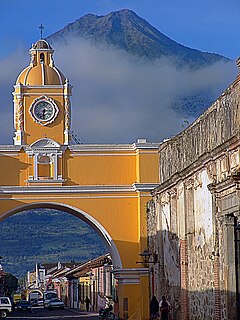
Antigua Guatemala, commonly referred to as just Antigua or la Antigua, is a city in the central highlands of Guatemala famous for its well-preserved Spanish Baroque-influenced architecture as well as a number of ruins of colonial churches. It served as the capital of the Kingdom of Guatemala. It has been designated a UNESCO World Heritage site.
Sacatepéquez is one of the 22 departments of Guatemala. Population estimate 265,500 in 2000. The name comes from Sacatepéquez, a city from November 21, 1542 until July 29, 1773 when it was destroyed by the 1773 Guatemalan Earthquake. Sacatepéquez means grasshill in the Nahuatl Language. The capital of Sacatepéquez is Antigua Guatemala which is home to an extensive textile marketplace and Plaza Major. Other important cities include Ciudad Vieja and San Lucaswhich is also hosts another popular marketplace and is a culinary attraction. The Chajoma were a group of indeginous people who were Kaqchikel speaking Indians identified Mixco Viejo as their capital, and spread throughout the Sacatepequez Department until their capital was moved to Ciudad Vieja, in Antigua.

San Cristóbal de las Casas, also known by its native Tzotzil name, Jovel, is a town and municipality located in the Central Highlands region of the Mexican state of Chiapas. It was the capital of the state until 1892, and is still considered the cultural capital of Chiapas.

Ciudad Victoria is the capital of the Municipality of Victoria and the Mexican state of Tamaulipas. It is located in the northeast of Mexico at the foot of the Sierra Madre Oriental. It borders the municipality of Güémez to the north, Llera to the south, Casas Municipality to the east, and the municipality of Jaumave to the west. The city is located 246 km (153 mi) from Monterrey and 319 km (198 mi) from the border with the United States. Ciudad Victoria is named after the first president of Mexico, Guadalupe Victoria.

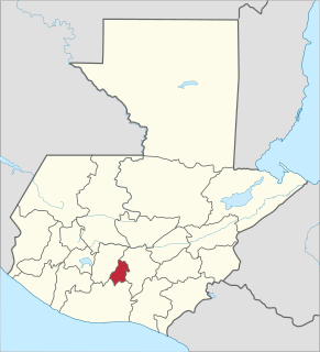
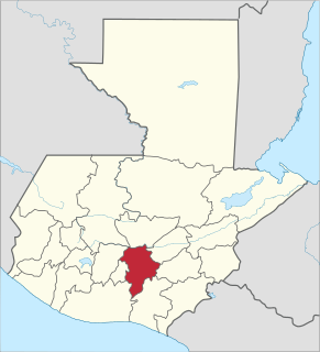
Chimaltenango is a department of Guatemala. The capital is Chimaltenango. Located to the east are the departments of Guatemala, home to Guatemala City, and Sacatepéquez, while also bordered by the departments of El Quiché and Baja Verapaz to the north, Escuintla and Suchitepéquez to the south, and Sololá Department to the west. The capital of Chimaltenango is located about 54 kilometers away from Guatemala City.
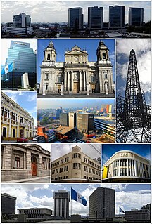
Guatemala is one of the 22 departments of Guatemala. The capital is Guatemala City, which also serves as the national capital. The department consists of Guatemala City and several of its suburbs.

The Estadio Nacional Doroteo Guamuch Flores is a multi-use national stadium in Guatemala City, the largest in Guatemala. It was built in 1948, to host the Central American and Caribbean Games in 1950, and was renamed after long-distance runner Doroteo Guamuch Flores, winner of the 1952 Boston Marathon. It has a capacity of 26,000 seats.

San Cristóbal Acasaguastlán is a town in the El Progreso department of Guatemala. San Cristóbal Acasaguastlán is located on the northern bank of the Motagua River at an altitude of 250 m. It had a population of 6,129 people at the 2002 census, and covers a territory of 124 square kilometres (48 sq mi). San Cristóbal Acasaguastlán borders on San Agustín Acasaguastlán to the northwest, Usumatlán to the east, and El Jicaro to the south. It is located on the inter-ocean highway (CA-9), 101 km from Guatemala City.
San Miguel Petapa is a municipality in the Guatemala department of Guatemala, located south of Guatemala City. It has a population of 94,228 according to the 2002 census.
San Cristóbal Cucho is a municipality in the San Marcos department of Guatemala.It was found on 11 October 1825. It was annexed to San Pedro Sacatepéquez, in 1935, but it was named a municipality again on 12 July 1945.

Nueva Santa Rosa is a municipality in the Santa Rosa department of Guatemala.
Poqomchiʼ is a Mayan language spoken by the Poqomchiʼ Maya of Guatemala, and is very closely related to Poqomam. Its two main dialects, eastern and western, were spoken by 90,000 or so people in the year 2000, in Purulhá, Baja Verapaz, and in the following municipalities of Alta Verapaz: Santa Cruz Verapaz, San Cristóbal Verapaz, Tactic, Tamahú and Tucurú. It is also the predominant language in the municipality of Chicamán, which borders Alta Verapaz.
Poqomam is a Mayan language, closely related to Poqomchiʼ. It is spoken by 50,000 or so people in several small pockets in Guatemala, the largest of which is in Jalapa department.

Ayutla is a municipality in the San Marcos Department of Guatemala. It is situated along the Suchiate River natural border with Mexico in the southern part of the department. The municipality center is Ciudad Tecún Umán. There is a combined road and rail bridge known as Puente Rodolfo Robles linking Ayutla to Ciudad Hidalgo in Chiapas, Mexico.
The Guatemala City metropolitan area is a conglomeration of densely populated municipalities surrounding Guatemala City. In 2005, the metropolitan area was defined by the governments of Guatemala and Guatemala City as comprising the municipalities of Amatitlán, Chinautla, Guatemala City, Mixco, San Miguel Petapa, Santa Catarina Pinula, Villa Canales and Villa Nueva. Together these eight municipalities cover 478 square kilometres and were projected by Guatemala's National Institute of Statistics to have a combined population of 2,749,161 in 2015.
Fraternidad Cristiana de Guatemala is an evangelical megachurch, current pentecostal, in Mixco, Guatemala. The senior pastor of this community is Jorge Lopez. In 2016, the attendance was 20,000 people.

The Relief Map of Guatemala is a huge relief map of Guatemala erected at ground level on two scales: 1: 10,000 for the horizontal extension and 1: 2,000 for the vertical, on an approximate surface of 1,800 square meters.