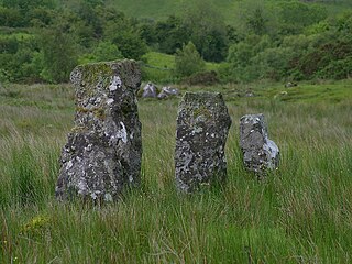
Drumskinny is the site of a stone circle in the townland of Drumskinny, County Fermanagh, Northern Ireland. With the inclusion of an adjacent cairn and alignment, the stone circle is a State Care Historic Monument in Fermanagh and Omagh district, at grid ref: H 2009 7072. The site was excavated in 1962 and is believed to have built around 2000 BC.

Letterbreen is a hamlet in County Fermanagh, Northern Ireland. It is 5 miles southwest of Enniskillen on the main route to Sligo. It lies in the foothills of Belmore Mountain.

Boho is a hamlet and a civil parish 11 kilometres (7 mi) covering approximately 12 km × 7 km southwest of Enniskillen in County Fermanagh, Northern Ireland. It is situated within Fermanagh and Omagh district.
Carrick is an Anglicised version of creag/carraig, Gaelic for "rock", and may refer to:
Skea is a small village and townland in County Fermanagh, Northern Ireland. It had a population of 114 people in the 2001 Census. It lies within the Fermanagh and Omagh District Council area.

Trory is a townland, small village and civil parish in County Fermanagh, Northern Ireland, 3 miles (5 km) north of Enniskillen. The townland is situated in the historic barony of Tirkennedy, but the civil parish covers areas of the barony of Tirkennedy, as well as the barony of Lurg. In the 2001 Census it had a population of 315 people. It lies within the Fermanagh and Omagh District Council area.

Kinawley or Kinawly is a small village, townland and civil parish straddling County Fermanagh, Northern Ireland and County Cavan Republic of Ireland. The village and townland are both in the civil parish of Kinawley in the historic barony of Clanawley, while other areas of the parish are in the baronies of Knockninny in County Fermanagh and Tullyhaw in County Cavan. In the 2011 Census it had a population of 141 people.
Derryvore is the name of three townlands in Northern Ireland.
Clogherbog is a townland in County Fermanagh, Northern Ireland. It is part of the civil parish of Boho, and contains the sub-townlands of Carrickrory, Lough Nacloyduff, Loughanquin, Loughnamanfin and Tullylaur. It is situated within Fermanagh and Omagh district.
Tullygerravra is a townland in the area of Belcoo, County Fermanagh, Northern Ireland. It used to be in the area of Boho and remains a part of the parish of Botha.
Clanawley is a barony in County Fermanagh, Northern Ireland. To its east lies Upper Lough Erne, and it is bordered by three other baronies: Magheraboy to the north; Tirkennedy and Knockninny to the east. It also borders three baronies in the Republic of Ireland: Tullyhaw to the south; and Drumahaire and Rosclogher to the west.

Tirkennedy is a barony in County Fermanagh, Northern Ireland. To its west lies Lower Lough Erne and south Upper Lough Erne, and it is bordered by seven other baronies: Clanawley and Magheraboy to the west; Lurg and Omagh East to the north; Clogher to the east; Magherastephana and Knockninny to the south.
Gortahurk, is a townland in the civil parish of Tomregan, County Fermanagh, Northern Ireland. It was also part of the barony of Knockninny.

Magheracross is a townland and civil parish in County Fermanagh, Northern Ireland. It extends in area from just north of Enniskillen to the border with County Tyrone. There is also a small enclave in County Tyrone.

Sidaire is a townland in Magheracross civil parish, County Fermanagh, Northern Ireland. It is located in the barony of Tirkennedy, in civil parish of Magheracross.

The Finn River, also known as the River Finn, is a small river that flows through parts of County Fermanagh and parts of County Monaghan in the south of Ulster, the northern province in Ireland. In certain places, the river forms part of the boundary between County Fermanagh, which is part of Northern Ireland, and County Monaghan, which is part of the Republic of Ireland. Two very short stretches of the river, just north of Redhills and at Castle Saunderson, near Belturbet, also form part of the boundary between County Fermanagh and County Cavan. This means that some stretches of the river form part of the border between Northern Ireland and the Republic of Ireland, these short stretches also forming part of the external border of the European Union.
