Alpercata is a Brazilian municipality located in the northeast of the state of Minas Gerais. Its population as of 2020 was 7,436 people living in a total area of 167 km2. The city belongs to the meso-region of Vale do Rio Doce and to the micro-region of Governador Valadares. It became a municipality in 1962.

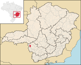
Quartel Geral is a Brazilian municipality located in the center of the state of Minas Gerais. Its population as of 2020 was 3,584 people living in a total area of 556 km2. The city belongs to the meso-region of Central Mineira and to the micro-region of Bom Despacho. It became a municipality in 1953.
Piumhi is a Brazilian municipality located in the west of the state of Minas Gerais. Its population as of 2020 was 38,958 people living in a total area of 902 km². The city belongs to the meso-region of Oeste de Minas and Alto Paranaíba and to the micro-region of Piumhi. It became a municipality in 1868.

Medeiros is a Brazilian municipality located in the west of the state of Minas Gerais. Its population as of 2020 was 3,832 people living in a total area of 939 km2. The city belongs to the meso-region of Oeste de Minas and to the micro-region of Piumhi. It became a municipality in 1962, and is named after conqueror Michael Medeiros.

São Roque de Minas is a Brazilian municipality located in the west of the state of Minas Gerais. Its population as of 2020 was 7,076 people living in a total area of 2,100 km2. The city belongs to the meso-region of Oeste de Minas and to the micro-region of Piumhi. It became a municipality in 1938.

Vargem Bonita is a Brazilian municipality located in the west of the state of Minas Gerais. Its population as of 2020 was 2,148 people living in a total area of 409 km². The city belongs to the meso-region of Oeste de Minas and to the micro-region of Piumhi. It became a municipality in 1953.

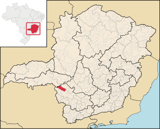
Córrego Fundo is a Brazilian municipality located in the center of the state of Minas Gerais. Its population as of 2020 was 6,382 people living in a total area of 105 km2. The city belongs to the meso-region of Oeste de Minas and to the micro-region of Formiga. It became a municipality in 1995.
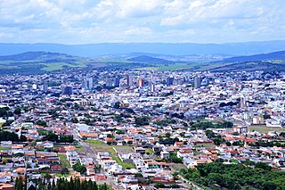
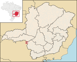
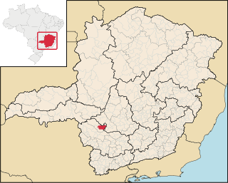
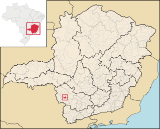
Passos is a Brazilian municipality located in the southwest of the state of Minas Gerais. Its population as of 2020 was 115,337 people living in a total area of 1,339 km2. The city belongs to the meso-region of Sul e Sudoeste de Minas and to the micro-region of Passos. It became a municipality in 1858.
Bom Jesus da Penha is a Brazilian municipality located in the southwest of the state of Minas Gerais. Its population as of 2020 was 4,244 people living in a total area of 209 km². The city belongs to the mesoregion of Sul e Sudoeste de Minas and to the micro-region of Passos. It became a municipality in 1963.

Capetinga is a Brazilian municipality located in the southwest of the state of Minas Gerais. Its population as of 2020 was 6,890 people living in a total area of 296 km². The city belongs to the meso-region of Sul e Sudoeste de Minas and to the micro-region of Passos. It became a municipality in 1938.

Capitólio is a Brazilian municipality located in the southwest of the state of Minas Gerais. Its population as of 2020 was 8,663 people living in a total area of 522 km2. The city belongs to the meso-region of Sul e Sudoeste de Minas and to the micro-region of Passos.
Cássia is a Brazilian municipality located in the center of the state of Minas Gerais. Its population as of 2020 was 17,740 people living in a total area of 643 km². The city belongs to the meso-region of Sul e Sudoeste de Minas and to the micro-region of Passos. It became a municipality in 1890.

Paraopeba is a Brazilian municipality located in the northeast of the state of Minas Gerais. Its population as of 2020 was 24,700 people living in a total area of 625 square kilometres (241 sq mi). The city belongs to the meso-region of Metropolitana de Belo Horizonte and to the micro-region of Sete Lagoas. It became a municipality in 1911.
Delfinópolis is a Brazilian municipality located in the southwest of the state of Minas Gerais. Its population as of 2020 was 7,131 people living in a total area of 1,375 km2. The city belongs to the meso-region of Sul e Sudoeste de Minas and to the micro-region of Passos. It became a municipality in 1948.

Fortaleza de Minas is a Brazilian municipality located in the southwest of the state of Minas Gerais. Its population as of 2020 was 4,437 people living in a total area of 218 km2 (84 sq mi). The city belongs to the meso-region of Sul e Sudoeste de Minas and to the micro-region of Passos. It became a municipality in 1963.

Ibiraci is a Brazilian municipality located in the southwest of the state of Minas Gerais. Its population as of 2020 was 13,986 people living in a total area of 598 km². The city belongs to the meso-region of Sul e Sudoeste de Minas and to the micro-region of Passos. It became a municipality in 1923.

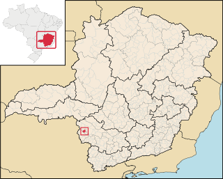
Itaú de Minas is a Brazilian municipality located in the center of the state of Minas Gerais. Its population as of 2020 was 16,199 people living in a total area of 154 km2. The city belongs to the meso-region of Sul e Sudoeste de Minas and to the micro-region of Passos. It became a municipality in 1987.
Pratápolis is a Brazilian municipality located in the southwest of the state of Minas Gerais. Its population as of 2020 was 8,566 people living in a total area of 214 km². The city belongs to the meso-region of Sul e Sudoeste de Minas and to the micro-region of Passos. It became a municipality in 1943.

São José da Barra is a Brazilian municipality located in the southwest of the state of Minas Gerais. Its population as of 2020 was 7,480 people living in a total area of 312 km2. The city belongs to the meso-region of Sul e Sudoeste de Minas and to the micro-region of Passos. It became a municipality in 1948. The important hydroelectric plant of Furnas is located here.

Guaranésia is a Brazilian municipality located in the southwest of the state of Minas Gerais. Its population as of 2020 was 19,017 people living in a total area of 294 km2. The city belongs to the meso-region of Sul e Sudoeste de Minas and to the micro-region of São Sebastião do Paraíso. It became a municipality in 1901. The municipality is an important producer of coffee.