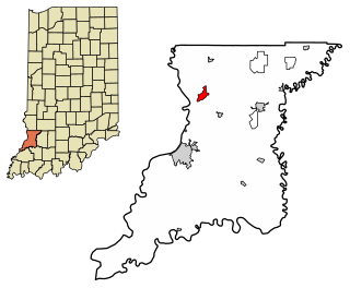
Decatur County is a county in the U.S. state of Indiana. As of the 2020 United States Census, the population was 26,472. The county seat is Greensburg.

Niwot is an unincorporated town, a post office, and a census-designated place (CDP) located in and governed by Boulder County, Colorado, United States. The CDP is a part of the Boulder, Colorado Metropolitan Statistical Area. The Niwot post office has the ZIP Codes 80503 and 80544. At the United States Census 2020, the population of the Niwot CDP was 4,306.
Druid Hills is a community which includes both a census-designated place (CDP) in unincorporated DeKalb County, Georgia, United States, as well as a neighborhood of the city of Atlanta. The CDP's population was 14,568 at the 2010 census. The CDP formerly contained the main campus of Emory University and the Centers for Disease Control and Prevention (CDC); however, they were annexed by Atlanta in 2018. The Atlanta-city section of Druid Hills is one of Atlanta's most affluent neighborhoods with a mean household income in excess of $238,500.

North Decatur is an unincorporated community and census-designated place (CDP) in DeKalb County, Georgia, United States. The population was 18,511 in 2020.
New Washington is a census-designated place (CDP) in Clark County, Indiana, United States. As of the 2010 census, the population was 566.

Roselawn is a census-designated place (CDP) in Newton and Jasper counties in the U.S. state of Indiana. The population was 4,131 at the 2010 census.
Clarksburg is a census-designated place and an unincorporated area in northern Montgomery County, Maryland, United States. It is located at the northern end of the Interstate 270 technology corridor, approximately four miles north of Germantown. As of the 2020 census, Clarksburg had a population of 29,051.
Clarksburg is a census-designated place in Yolo County, California. It is located on the Sacramento River, in the extreme southeastern corner of the county. It lies at an elevation of 10 feet in ZIP code 95612 and area codes 916 and 279.
Harlan is an unincorporated census-designated place (CDP) in Springfield Township, Allen County, in the U.S. state of Indiana. As of the 2010 census, Harlan had a population of 1,634.

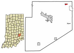
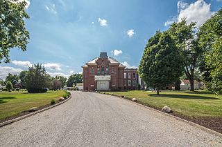
Fugit Township is one of nine townships in Decatur County, Indiana. As of the 2020 census, its population was 1,856 at and it contained 944 housing units.

Raglesville is an unincorporated community and census-designated place (CDP) in Van Buren Township, Daviess County, Indiana, United States. As of the 2010 census it had a population of 141.

Dubois is an unincorporated town and census-designated place (CDP) in Dubois County, Indiana, United States. Its population at the 2010 census was 488.

Point Isabel is an unincorporated community and census-designated place (CDP) in central Green Township, Grant County, Indiana, United States. It lies at the intersection of State Roads 13 and 26. As of the 2010 census it had a population of 91.

New Trenton is an unincorporated community and census-designated place (CDP) in Whitewater Township, Franklin County, Indiana. As of the 2010 census it had a population of 252. It has a ZIP code 47035.

Jalapa is an unincorporated community and census-designated place (CDP) in Pleasant Township, Grant County, Indiana, United States. As of the 2010 census it had a population of 171. The site of the Battle of the Mississinewa, fought during the War of 1812, is nearby.

Sims is an unincorporated community and census-designated place (CDP) in Sims Township, Grant County, Indiana. In 2010 it had a population of 156.

Scotland is an unincorporated community and census-designated place (CDP) in Taylor Township, Greene County, Indiana, United States. As of the 2010 census it had a population of 134.
Emison is an unincorporated community and census-designated place (CDP) in Busseron Township, Knox County, Indiana. Its population was 154 at the 2010 census.

Westphalia is an unincorporated community and census-designated place (CDP) in Vigo Township, Knox County, Indiana. As of the 2010 census it had a population of 202.

Lake Santee is an unincorporated town and census-designated place in Decatur and Franklin counties, Indiana, United States. As of the 2010 census, it had a population of 820.