
Clay County is a county located in the U.S. state of Indiana. As of 2020, the population was 26,466. The county seat is Brazil.
Preble County is a county located in the U.S. state of Ohio. As of the 2020 census, the population was 40,999, down 3.0% from the 2010 census population of 42,270. Its county seat is Eaton. The county was formed on February 15, 1808, from portions of Butler and Montgomery Counties. It is named for Edward Preble, a naval officer who fought in the American Revolutionary War and against the Barbary Pirates.

Union County is a county in the U.S. state of Indiana. As of the 2020 United States census, the population was 7,087. The county seat is Liberty.

Ripley County is a county located at the southeastern corner of the U.S. state of Indiana. According to the 2020 Census, the population was 28,995. The county seat is Versailles.

Parke County lies in the western part of the U.S. state of Indiana along the Wabash River. The county was formed in 1821 out of a portion of Vigo County. According to the 2020 census, the population was 16,156. The county seat is Rockville.

Owen County is a county in the U.S. state of Indiana. In 1920 the United States Census Bureau calculated the mean center of U.S. population to fall within this county. As of the 2020 United States Census, it had a population of 21,321. Its county seat is Spencer.

Ohio County is a county located in southeastern Indiana. With a 2020 population of 5,940, and an area of just 87 square miles, Ohio County is the smallest county in Indiana by area and the least populous. The county seat and only incorporated municipality is Rising Sun. The county was officially established in 1844 and was one of the last Indiana counties to be created. Ohio County borders the state of Kentucky across the Ohio River for which it was named. It is part of the Cincinnati, OH-KY-IN Metropolitan Statistical Area. The county is divided into four townships which provide local services. Three state roads pass through or into the county.

Marion County is located in the U.S. state of Indiana. The 2020 United States census reported a population of 977,203, making it the most populous county in the state and 51st most populated county in the country. Indianapolis is the county seat, the state capital, and most populous city. Marion County is consolidated with Indianapolis through an arrangement known as Unigov.

Madison County is a county in the U.S. state of Indiana. The 2020 census states the population is standing at 130,129. The county seat since 1836 has been Anderson, one of three incorporated cities within the county.

Jay County is a county in the U.S. state of Indiana. As of 2020, the population was 20,478. The county seat is Portland.

Greene County is a county in the U.S. state of Indiana. As of 2020, the population was 30,803. The county seat is Bloomfield. The county was determined by the US Census Bureau to include the mean center of U.S. population in 1930.

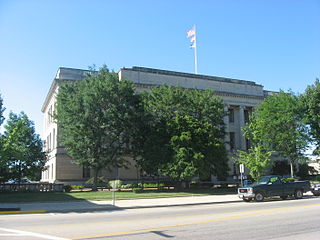
Decatur County is a county in the U.S. state of Indiana. As of the 2020 United States Census, the population was 26,472. The county seat is Greensburg.

Daviess County is a county in the U.S. state of Indiana. As of the 2020 United States Census, the population was 33,381. The county seat is Washington. About 15% of the county's population is Amish of Swiss origin, as of 2017.

Notre Dame is a census-designated place and unincorporated community north of the city of South Bend in St. Joseph County, in the U.S. state of Indiana. It includes the campuses of three colleges: the University of Notre Dame, Saint Mary's College, and Holy Cross College. Notre Dame is split between Clay and Portage Townships. As of the 2020 census, its population was 7,234.
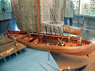
A knarr is a type of Norse merchant ship used by the Vikings for long sea voyages and during the Viking expansion. The knarr was a cargo ship; the hull was wider, deeper and shorter than a longship, and could take more cargo and be operated by smaller crews. It was primarily used to transport trading goods like walrus ivory, wool, timber, wheat, furs and pelts, armour, slaves, honey, and weapons. It was also used to supply food, drink, weapons and armour to warriors and traders along their journeys across the Baltic, the Mediterranean and other seas. Knarrs routinely crossed the North Atlantic carrying livestock such as sheep and horses, and stores to Norse settlements in Iceland, Greenland and Vinland as well as trading goods to trading posts in the British Isles, Continental Europe and possibly the Middle East. The knarr was constructed using the same clinker-built method as longships, karves, and faerings.
Kankakee Township is one of twenty-one townships in LaPorte County, Indiana. As of the 2010 census, its population was 4,830 and it contained 1,859 housing units.

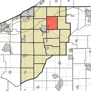
Sand Creek Township is one of nine townships in Decatur County, Indiana, United States. As of the 2010 census, its population was 3,120 and it contained 1,331 housing units.

Washington Township is one of nine townships in Decatur County, Indiana. As of the 2010 census, its population was 13,304 and it contained 5,944 housing units.

Franklin Township is one of eleven townships in Ripley County, Indiana. As of the 2010 census, its population was 3,773 and it contained 1,541 housing units.


