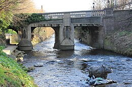
Ballsbridge is an affluent neighbourhood of the city of Dublin, the capital of Ireland. The area is largely situated north and west of a three-arch stone bridge across the River Dodder, on the south side of the city. The sign on the bridge still proclaims it as "Ball's Bridge", in recognition of the fact that the original bridge on that location was built and owned by the Ball family, a well-known Dublin merchant family in the 1500s and the 1600s. The current bridge was built in 1791.

The River Liffey is a river in eastern Ireland that ultimately flows through the centre of Dublin to its mouth within Dublin Bay. Its major tributaries include the River Dodder, the River Poddle and the River Camac. The river supplies much of Dublin's water and supports a range of recreational activities.

The Ha'penny Bridge, known later for a time as the Penny Ha'penny Bridge, and officially the Liffey Bridge, is a pedestrian bridge built in May 1816 over the River Liffey in Dublin, Ireland. Made of cast iron, the bridge was cast in Shropshire, England.
Rathfarnham is a southside suburb of Dublin, Ireland in County Dublin. It is south of Terenure, east of Templeogue, and is in the postal districts of Dublin 14 and 16. It is between the local government areas of Dún Laoghaire–Rathdown and South Dublin.

Templeogue is a southwestern suburb of Dublin in Ireland. It lies between the River Poddle and River Dodder, and is about halfway from Dublin's centre to the mountains to the south.

Ringsend is a southside inner suburb of Dublin, Ireland. It is located on the south bank of the River Liffey and east of the River Dodder, about two kilometres east of the city centre. It is the southern terminus of the East Link Toll Bridge. Areas included in Ringsend are the south side of the Dublin Docklands, and at the west end is the area of South Lotts and part of the Grand Canal Dock area. Neighbouring areas include Irishtown, Sandymount and the Beggars Bush part of Ballsbridge to the south, and the city centre to the west. A key feature of the area is the chimneys of Poolbeg power station.

O'Brien's Bridge or O'Briensbridge is a village in east County Clare, Ireland, on the west bank of the River Shannon, in a civil parish of the same name. It is named for the bridge across the Shannon at that point, built by Turlough O'Brien in 1506.

The River Dodder is one of the three main rivers in Dublin, Ireland, the others being the Liffey, of which the Dodder is the largest tributary, and the Tolka.

The West-Link is a toll bridge on the M50 motorway to the west of Dublin, Ireland, operated by Emovis for Transport Infrastructure Ireland.

Father Mathew Bridge is a road bridge spanning the River Liffey in Dublin, Ireland, which joins Merchants Quay to Church Street and the north quays. It occupies the approximate site of the original, and for many years the only, Bridge of Dublin, dating back to the 11th century.

Milltown is a suburb and townland on the southside of Dublin, Ireland. Milltown was the site of several working mills on the River Dodder and is also the location of the meeting of the River Slang with the Dodder. It is located adjacent to other suburban areas such as Windy Arbour, Ranelagh, Rathmines, Dartry, Clonskeagh, and Donnybrook.

Bennettsbridge is a village in County Kilkenny in Ireland. It is situated on the River Nore 6 kilometres (3.7 mi) south of Kilkenny city, in the centre of the county. Bennettsbridge is a census town, and had population of 745 as of the 2016 census.

Lucan Bridge is a road bridge spanning the River Liffey in Lucan, County Dublin, Ireland. It joins Lucan's Main Street to the Lower Lucan Road, carrying traffic towards Clonsilla and the north, and the Strawberry Beds to the east. Designed by George Knowles, it was built in 1814. Constructed in collaboration with James Savage at a cost of more than £9,000, it replaced several previous bridges which had been carried away by floods.

Island Bridge, formerly Sarah or Sarah's Bridge, is a road bridge spanning the River Liffey, in Dublin, Ireland which joins the South Circular Road to Conyngham Road at the Phoenix Park.

Firhouse is an outer suburb of Dublin, in the county of South Dublin, in the south of the traditional County Dublin in Ireland. It developed from a rural village by the River Dodder, with a second settlement, Upper Fir-house, nearby. It is just outside the M50 orbital motorway, and in the postal district of Dublin 24. It is adjacent to Knocklyon, Ballycullen, and Tallaght. In the historic divisions of local administration, Firhouse is in the civil parish of Tallaght and the barony of Uppercross.
O'Briensbridge–Montpelier is an urban area in Ireland, comprising the villages of O'Briensbridge in County Clare and Montpelier in County Limerick which face each other across the River Shannon. The combined census town had a population of 396 at the 2016 census.

Dartry is a small suburb of Dublin, Ireland, often referred to as a corridor between Rathmines area and Milltown. Among the locations in Dartry are Dartry Road, Temple Road, Orwell Park and Palmerston Park.
Milltown Bridge may refer to:

Milltown is a stop on the Luas light rail tram system in Dublin, Ireland which serves Milltown, Dublin and southern parts of Dartry, including Trinity Hall. It opened in 2004 as a stop on the Green Line, which re-uses the alignment of the Harcourt Street railway line which closed in 1958. Milltown Luas stop is located a few yards north of the site of the former rail station of the same name.
Strawberry Beds or The Strawberry Beds is a locality and small settlement 7 km to the west of Dublin City, Ireland, located on the northern banks of the River Liffey between Chapelizod and Lucan where the closest bridges span the river. The populated suburb of Palmerstown lies just south of the Strawberry Beds, but is inaccessible due to the Liffey which separates them. The R109 road, also known as the 'Lower Road' for the section between Chapelizod and Lucan, is the only road that passes through the Strawberry Beds. The area is protected by a Special Amenity Area Order (SAAO).