The City of Chelmsford is a local government district in Essex, England. It is named after its main settlement, Chelmsford, which is also the county town of Essex. On 1 June 2012 Chelmsford was granted city status to mark the Diamond Jubilee of Elizabeth II.

Asheldham is a village and civil parish in Essex, England. It is located about 14 km (8.7 mi) southeast of Maldon and is 26 km (16 mi) east-southeast from the county town of Chelmsford. The village is in the district of Maldon and the parliamentary constituency of Maldon & East Chelmsford. The village is part of Asheldham and Dengie Parish Council.

Bradwell Waterside is a small hamlet in Essex, England. It is located about 9 km (5.6 mi) north-northeast of Southminster and is 28 km (17 mi) east from the county town of Chelmsford. The hamlet is in the district of Maldon and the parliamentary constituency of Maldon & East Chelmsford. The population of the hamlet is included in the civil parish of Bradwell-on-Sea.

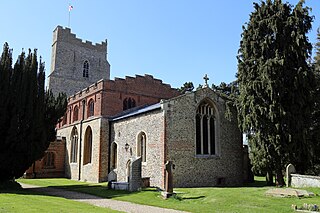
Stapleford Tawney is a village and civil parish in the Epping Forest district of Essex, England. Stapleford Tawney is approximately 4 miles (6 km) west-southwest from Chipping Ongar and 14 miles (23 km) southwest from the county town of Chelmsford.

Stock is a village and civil parish in south Essex, England. It is about 6 miles (10 km) south of Chelmsford, the county town. The village is in the borough of Chelmsford and in the parliamentary constituency of Maldon.
Church End is a hamlet in the civil parish of Shalford, and the Braintree district of Essex, England. The parish village of Shalford is less than 1 mile north from Church End, and the town of Braintree approximately 3.5 miles (6 km) southeast.
Chelmsford Rural District was a local government district in Essex, England from 1894 to 1974. It surrounded, but did not include, the town of Chelmsford; which formed a municipal borough.

Cherry Green or Chaureth Green is a hamlet in the civil parish of Broxted and the Uttlesford District of Essex, England. The hamlet is 1.5 miles (2.4 km) north from the parish village of Broxted, 2.5 miles (4.0 km) west from the town of Thaxted, and 16 miles (30 km) northwest from the county town of Chelmsford.

King Street is a hamlet in the High Ongar civil parish of the Epping Forest district of Essex, England. The hamlet, a linear development along the road of King Street, is 300 yards (274 m) south from the A414 Harlow to Chelmsford road. King Street is 1.5 miles (2 km) east from the parish village of High Ongar, and less than 1 mile north from the hamlet of Nine Ashes. The county town of Chelmsford is 8 miles (13 km) to the east.

Chalk End is a hamlet in the civil parish of Roxwell and the Chelmsford District of Essex, England. The hamlet is 1.5 miles (2.4 km) northwest from the parish village of Roxwell, and lies on the A1060 Bishop's Stortford to Chelmsford road.

Chatham Green is a hamlet in the civil parish of Little Waltham and the Chelmsford District of Essex, England. The hamlet is 1.5 miles (2.4 km) north from Little Waltham village, and approximately 4 miles (6 km) north from the county town of Chelmsford. Chatham Green is adjacent to the A131 road, which runs to the A130, combined being the road from Braintree to Chelmsford.
Fanner's Green is a hamlet and cul-de-sac road in the Great Waltham civil parish of the Chelmsford district of Essex, England. It is situated 1 mile (1.6 km) south-west from the village of Great Waltham. The county town of Chelmsford is approximately 2 miles (3 km) to the south-east. Fanner's Green comprises Fanner's farm, and a barn 200 yards (183 m) south on Breed's Road.
Cooksmill Green is a hamlet in both the civil parish of Roxwell and Highwood in the Chelmsford District of Essex, England. It is situated approximately 4 miles (6 km) west from the centre of the county town of Chelmsford. The A414 road is less than one mile to the south.

Threshers Bush or Thresher's Bush is a hamlet and road in the civil parishes of both Matching and High Laver, and the Epping Forest district of Essex, England.

Howe Street is a hamlet in the Finchingfield civil parish of the Braintree District of Essex, England. The hamlet is a linear settlement of 1,000 yards (900 m) length, and is 1 mile (1.6 km) northeast from the village of Finchingfield. The county town of Chelmsford is 16 miles (26 km) to the south.

Bishop's Green is a hamlet in the civil parish of High Easter, in the Uttlesford district of Essex, England. The hamlet is on the road between the villages of High Easter and Barnston. The hamlet of Wellstye Green is less than 1 mile (1.6 km) northeast.

Birds Green is a hamlet in the civil parish of Abbess, Beauchamp and Berners Roding and the Epping Forest district of Essex, England. The hamlet is within The Rodings group of civil parishes, and is 9 miles (14 km) west from the county town of Chelmsford. The village of Beauchamp Roding is less than 1 mile (1.6 km) to the north, and Fyfield 1.5 miles (2.4 km) to the south.

Tawney Common also known as Woodhatch, is a hamlet in the civil parish of Stapleford Tawney in the Epping Forest district of the county of Essex, England. It is approximately 2.5 miles (4 km) east of Epping, 4 miles (6 km) west of Chipping Ongar and 13 miles (20 km) west from the county town of Chelmsford. Stapleford Tawney is approximately 2 miles (3 km) to the south. Tawney Common is south of the hamlet of Collier's Hatch, also in the Stapleford Tawney parish.