
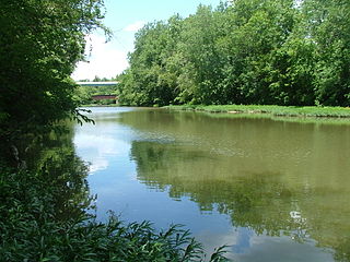
The Hocking River is a 102-mile-long (164 km) right tributary of the Ohio River in southeastern Ohio in the United States.

The Stillwater River is a 69.3-mile-long (111.5 km) tributary of the Great Miami River in western Ohio in the United States. Via the Great Miami and Ohio rivers, it is part of the Mississippi River watershed.

The St. Joseph River is an 86.1-mile-long (138.6 km) tributary of the Maumee River in northwestern Ohio and northeastern Indiana in the United States, with headwater tributaries rising in southern Michigan. It drains a primarily rural farming region in the watershed of Lake Erie.

The Licking River is a tributary of the Muskingum River, about 40 mi (65 km) long, in central Ohio in the United States. Via the Muskingum and Ohio Rivers, it is part of the watershed of the Mississippi River.

Sugar Creek is an 82.4-mile-long (132.6 km) tributary of the Driftwood River in east-central Indiana in the United States. Via the Driftwood, White, Wabash and Ohio rivers, it is part of the watershed of the Mississippi River.
Paint Creek is a tributary of the Scioto River, 94.7 miles (152.4 km) long, in south-central Ohio in the United States. Via the Scioto and Ohio Rivers, it is part of the watershed of the Mississippi River. It drains an area of 1,143 square miles (2,960 km2).
Tygarts Creek is a tributary of the Ohio River in Carter and Greenup counties of northeastern Kentucky in the United States. It is 88 miles (142 km) long and drains an area of 339.6 square miles (880 km2). Via the Ohio, it is part of the watershed of the Mississippi River. Tygarts Creek is named for early Kentucky explorer Michael Tygart, who eventually drowned in the creek, somewhere near the mouth.

Moxahala Creek is a tributary of the Muskingum River, 29.2 miles (47.0 km) long, in southeastern Ohio in the United States. Via the Muskingum and Ohio Rivers, it is part of the watershed of the Mississippi River, draining an area of 301 square miles (780 km2)
Blacklick Creek is a tributary stream of Big Walnut Creek in Ohio, flowing through Licking, Fairfield and Franklin counties. The creek's name was originally given by Native Americans, who had noticed the animals that frequented the creek to lick its black-colored salt stones. It has also been known as Black Lick Creek, Black Lick Fork, Blacks Lick Creek, and Big Lick Creek.

Haydenville is an unincorporated community and census-designated place (CDP) in southern Green Township, Hocking County, Ohio, United States. As of the 2020 census the population of the CDP was 337.

Carbondale is an unincorporated community in northwestern Waterloo Township, Athens County, Ohio, United States. It has a post office with the ZIP code 45717. It is located a short distance north of State Route 56.
Royalton is an unincorporated community in northern Amanda Township, Fairfield County, Ohio, United States.
Margaret Creek is a stream and state waterway in Athens and Meigs Counties, Ohio. Along with Monday, Sunday, and Federal Creeks, Margaret Creek is a principal tributary to the Hocking River. The confluence with the Hocking River is on the west side of the city of Athens, Ohio. The stream was named after Margaret Snowden, the first white woman settler in Athens County.
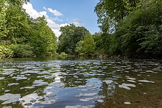
Raccoon Creek is a 114-mile-long (183 km) stream that drains parts of five Ohio counties in the United States. It originates in Hocking County, Ohio. It flows through Vinton County and Gallia County and a corner of Meigs County. Its largest tributary, Little Raccoon Creek, arises in Jackson County. The watershed also includes part of Athens County, drained by another tributary, Hewett Fork. The other major tributaries are Elk Fork, located entirely in Vinton County, and Brushy Fork, which is mostly in Vinton County with a small area in Hocking County.
Queer Creek is a stream in Hocking County, Ohio, in the United States.
Eagle Mills is an unincorporated community in Vinton County, in the U.S. state of Ohio.
Threemile Creek is a stream in Hocking County, Ohio. It is a tributary of the Hocking River.
Jobs is an unincorporated community in Hocking County, in the U.S. state of Ohio.
Monday is an unincorporated community in Hocking County, in the U.S. state of Ohio.
Hartleyville is an unincorporated community in Athens County, in the U.S. state of Ohio. The community lies near the mouth of Johnson Run creek.

