Related Research Articles

The Hackensack River is a river, approximately 45 miles (72 km) long, in the U.S. states of New York and New Jersey, emptying into Newark Bay, a back chamber of New York Harbor. The watershed of the river includes part of the suburban area outside New York City just west of the lower Hudson River, which it roughly parallels, separated from it by the New Jersey Palisades. It also flows through and drains the New Jersey Meadowlands. The lower river, which is navigable as far as the city of Hackensack, is heavily industrialized and forms a commercial extension of Newark Bay.

The Wolf River is a 105-mile-long (169 km) alluvial river in western Tennessee and northern Mississippi, whose confluence with the Mississippi River was the site of various Chickasaw, French, Spanish and American communities that eventually became Memphis, Tennessee. It is estimated to be about 12,000 years old, formed by glacier runoff carving into the region's soft alluvial soil. It should not be confused with The Wolf River which flows primarily in Middle Tennessee and southern Kentucky. The Wolf River rises in the Holly Springs National Forest at Baker's Pond in Benton County, Mississippi, and flows northwest into Tennessee, before entering the Mississippi River north of downtown Memphis.

The Kaskaskia River is a tributary of the Mississippi River, approximately 325 miles (523 km) long, in central and southern Illinois in the United States. The second largest river system within Illinois, it drains a rural area of farms, as well as rolling hills along river bottoms of hardwood forests in its lower reaches. The lower reaches of the river have been canalized to allow barge traffic. In 1819, Vandalia up the river in the interior of the then new state of Illinois was chosen as its capital, which it served as until 1839.

The Shawnee Hills are a region within the larger Interior Low Plateaus physiographic province located in southern Illinois, southern Indiana, and western Kentucky. In Illinois it rests mainly in an east–west arc roughly following the outline of the southern end of the Illinois Basin. Whereas Mississippian and Pennsylvanian Age rock layers are deep beneath the soil surface in central Illinois, these strata pierce the surface in southern Illinois. The Shawnee Hills are surface expressions of the more weather-resistant limestone and sandstone layers. This formation is due in part to the last glaciation of the Ice Age not reaching this far south.

Ballona Creek is an 8.5-mile (13.7 km) channelized stream in southwestern Los Angeles County, California, United States, that was once a "year-round river lined with sycamores and willows". The urban watercourse begins in the Mid-City neighborhood of Los Angeles, flows through Culver City and Del Rey, and passes the Ballona Wetlands Ecological Preserve, the sailboat harbor Marina del Rey, and the small beachside community of Playa del Rey before draining into Santa Monica Bay. The Ballona Creek drainage basin carries water from the Santa Monica Mountains on the north, from the Baldwin Hills to the south, and as far as the Harbor Freeway (I-110) to the east.
The Des Plaines River is a river that flows southward for 133 miles (214 km) through southern Wisconsin and northern Illinois in the United States Midwest, eventually meeting the Kankakee River west of Channahon to form the Illinois River, a tributary of the Mississippi River.

The Shawnee National Forest is a United States National Forest located in the Ozark and Shawnee Hills of Southern Illinois, United States. Administered by the U.S.D.A. Forest Service, it consists of approximately 498,615 acres (2,100 km²) of federally managed lands. In descending order of land area it is located in parts of Pope, Jackson, Union, Hardin, Alexander, Saline, Gallatin, Johnson, and Massac counties. Forest headquarters are located in Harrisburg, Illinois. There are local ranger district offices in Jonesboro and Vienna. The Shawnee National Forest is also the single largest publicly owned body of land in the state of Illinois. It is considered part of Southern Illinois, and is south of the St. Louis, Missouri, and Metro East areas, in area code 618. Portions of it are in the far south area of Illinois known as Little Egypt. Cities in or near the area are Carbondale, Illinois, Marion, Illinois, and Cairo, Illinois.
The Potomac Highlands of West Virginia, or simply the Potomac Highlands, centers on five West Virginian counties in the upper Potomac River watershed in the western portion of the state's eastern panhandle, bordering Maryland and Virginia. Because of geographical proximity, similar topography and landscapes, and shared culture and history, the Potomac Highlands region is also considered to include Pocahontas, Randolph, and Tucker Counties, even though they are in the Monongahela River or New River watersheds and not the Potomac River watershed.
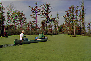
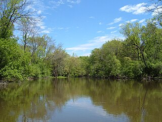
The Cache River is a 92-mile-long (148 km) waterway in southernmost Illinois, in a region sometimes called Little Egypt. The basin spans 737 square miles (1,910 km2) and six counties: Alexander, Johnson, Massac, Pope, Pulaski, and Union. Located at the convergence of four major physiographic regions, the river is part of the largest complex of wetlands in Illinois. The Cache River Wetlands is America's northernmost cypress/tupelo swamp and harbors 91 percent of the state's high quality swamp and wetland communities. It provides habitat for more than 100 threatened and endangered species in Illinois. In 1996, the Cache was designated a Wetland of International Importance under the Ramsar Convention.
The Big Muddy River is a 156-mile-long (251 km) river in southern Illinois. It joins the Mississippi River just south of Grand Tower. The Big Muddy has been dammed near Benton, forming Rend Lake.

Mountain Fork, also known as the Mountain Fork of the Little River, is a 98-mile-long (158 km) tributary of the Little River in western Arkansas and southeastern Oklahoma in the United States. Via the Little and Red rivers, it is part of the watershed of the Mississippi River. The stream rises in the Ouachita Mountains. Broken Bow Lake is an artificial lake along the course of the Mountain Fork. The stream is known for canoeing, kayaking, and sport fishing, including for stocked trout.

The Saline River is a tributary of the Ohio River, approximately 27 miles (43 km) long, in the Southern Illinois region of the U.S. state of Illinois. The river drains a large section of southeast Illinois, with a drainage basin of 1,762 square miles (4,564 km2). The major tributaries include the South Fork, Middle Fork and North Fork, all lying within the Saline Valley. The once meandering swampy river was important among Native Americans and early settlers as a source of salt from numerous salt springs where it was commercially extracted in the early 19th century.
Wakatomika Creek is a tributary of the Muskingum River, 42.6 mi (68.6 km) long, in central Ohio in the United States. Via the Muskingum and Ohio Rivers, it is part of the watershed of the Mississippi River, draining an area of 234 mi² (606 km²)

Mark West Creek is a 29.9-mile-long (48.1 km) stream that rises in the Mayacamas Mountains of Sonoma County, California, United States. Tributaries of Mark West Creek include Porter Creek and Hummingbird Creek, both of which originate in the same mountain range. Discharge waters of Mark West Creek reach the Russian River after a confluence with the Laguna de Santa Rosa. The Community Clean Water Institute has developed a program for monitoring pollutants in Mark West Creek.

The Long Prairie River is a tributary of the Crow Wing River, 96 miles (154 km) long, in central Minnesota in the United States. Via the Crow Wing River, it is part of the watershed of the Mississippi River, draining an area of 892 square miles (2,310 km2) in a generally rural region.
The Bald Knob Wilderness is a 5,973-acre (24.2 km²) parcel of land listed as a Wilderness Area of the United States. It is, by acreage, the second largest wilderness area located within the U.S. state of Illinois. It is located within the Shawnee National Forest in northwestern Union County, Illinois.

The Clear Springs Wilderness is a 4,730-acre (19.1 km2) parcel of land listed as a Wilderness Area of the United States. Adjacent to it is the LaRue-Pine Hills Research Natural Area, a National Natural Landmark noted for a large and diverse population of snakes.
The Bay Creek Wilderness is a 2,866-acre (11.60 km2) parcel of land listed as a Wilderness Area of the United States. It is located within the Shawnee National Forest in Pope County, Illinois. The nearest town of any size is Eddyville.

Rock Creek is a freestone stream in the northeastern part of the U.S. state of Wyoming. It is a tributary of Clear Creek, within the Powder River watershed. Its source is located in the Rock Creek Roadless Area. According to the U.S. Geological Survey, Rock Creek drains approx. 60 miles (97 km) before discharging into Clear Creek, just east of the city of Buffalo and Interstate 90.
References
- ↑ U.S. Geological Survey Geographic Names Information System: Clear Creek
- ↑ U.S. Geological Survey Geographic Names Information System: Clear Creek Ditch
- 1 2 Illinois Atlas and Gazetteer. Freeport, Maine: DeLorme Mapping. 1991. ISBN 0-89933-213-7.