
Monroe County is a county in the U.S. state of Indiana. In 1910 the US Census Bureau calculated the nation's mean population center to lie in Monroe County. The population was 137,974 at the 2010 United States Census. The county seat is Bloomington.

Bloomington is a city in and the county seat of Monroe County in the southern region of the U.S. state of Indiana. It is the seventh-largest city in Indiana and the fourth-largest outside the Indianapolis metropolitan area. According to the Monroe County History Center, Bloomington is known as the "Gateway to Scenic Southern Indiana." The city was established in 1818 by a group of settlers from Kentucky, Tennessee, the Carolinas, and Virginia who were so impressed with "a haven of blooms" that they called it Bloomington.

Roaring Fork River is a tributary of the Colorado River, approximately 70 miles (110 km) long, in west central Colorado in the United States. The river drains a populated and economically vital area of the Colorado Western Slope called the Roaring Fork Valley or Roaring Fork Watershed, which includes the resort city of Aspen and the resorts of Aspen/Snowmass.

The St. Joseph River is an 86.1-mile-long (138.6 km) tributary of the Maumee River in northwestern Ohio and northeastern Indiana in the United States, with headwater tributaries rising in southern Michigan. It drains a primarily rural farming region in the watershed of Lake Erie.

The Feather River is the principal tributary of the Sacramento River, in the Sacramento Valley of Northern California. The river's main stem is about 73 miles (117 km) long. Its length to its most distant headwater tributary is just over 210 miles (340 km). The main stem Feather River begins in Lake Oroville, where its four long tributary forks join together—the South Fork, Middle Fork, North Fork, and West Branch Feather Rivers. These and other tributaries drain part of the northern Sierra Nevada, and the extreme southern Cascades, as well as a small portion of the Sacramento Valley. The total drainage basin is about 6,200 square miles (16,000 km2), with approximately 3,604 square miles (9,330 km2) above Lake Oroville.
Clear Creek may refer to:
Lake Lemon is a reservoir located in southern Indiana approximately 10 miles (16 km) northeast of Bloomington, Indiana. It is bounded by private and public property in Monroe County and Brown County, with the eastern end of the lake in Brown County. The surface area of the lake is 1,650 acres (670 ha), making it the 11th largest lake in Indiana. There are 24 miles (39 km) of shoreline. The lake has an average depth of 9.7 feet (3.0 m) at full pool level. The greatest depth is somewhat in excess of 20 feet (6.1 m), matching with the original Bean Blossom Creek bed.

Wheeling Creek is a tributary of the Ohio River, 25 miles (40 km) long, in the Northern Panhandle of West Virginia in the United States, with a watershed extending into southwestern Pennsylvania. Via the Ohio River, it is part of the watershed of the Mississippi River, draining an area of approximately 300 square miles (780 km2) on the unglaciated portion of the Allegheny Plateau. It flows into the Ohio River in downtown Wheeling, just downstream of Ohio's Wheeling Creek on the opposite bank. A variant name is Big Wheeling Creek.

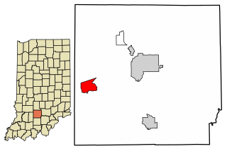
Clear Creek Township is one of eleven townships in Monroe County, Indiana, United States. As of the 2010 census, its population was 5,000 and it contained 2,674 housing units.

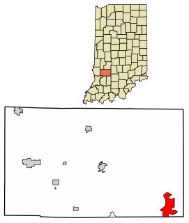
Perry Township is one of eleven townships in Monroe County, Indiana, United States. As of the 2010 census, its population was 50,673 and it contained 24,194 housing units.
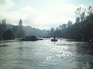
The South Fork American River is a major tributary of the American River in El Dorado County, California, draining a watershed on the western slope of the Sierra Nevada east of Sacramento. The river begins in pristine Desolation Wilderness and flows through the Sierra Nevada foothills. The river at Coloma was the site of James Marshall's discovery of gold at Sutter's Mill on January 24, 1848, which started the California Gold Rush. The South Fork of the American is "the most popular recreation stream in the West" for whitewater rafting in North America, e.g., 80,000 visitors in 2011.
Owensburg is an unincorporated community and census-designated place (CDP) in Jackson Township, Greene County, Indiana, United States. It was named in honor of the Owens family of early settlers. As of the 2010 census it had a population of 406.
Williams is an unincorporated community and census-designated place in Spice Valley Township, Lawrence County, Indiana, United States. As of the 2010 census, the population was 286.
Fall Creek is a navigable in law waterway in the U.S. state of Indiana, and a tributary of the White River. It is 57.5 miles (92.5 km) long and has a watershed drainage area of 318 square miles (820 km2) in central Indiana before flowing into the White River in Indianapolis. As it flows southwest, Fall Creek is the namesake of three townships in Indiana, in Henry County, Madison County, and then Hamilton County.

The North Fork Payette River is a river in western Idaho in the United States. It flows about 113 miles (182 km) southwards from the Salmon River Mountains to near Banks, where it empties into the Payette River, a tributary of the Snake River. It drains a watershed of 912 square miles (2,360 km2), consisting of mountains and forests, and valleys filled with large lakes and wetlands.

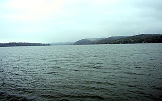
Salt Creek is a stream in the southern part of the U.S. state of Indiana. A tributary of the East Fork of the White River, the creek begins in southwestern Bartholomew County, flows through southern parts of Brown and Monroe counties, and meets the White River just downstream from Bedford in Lawrence County. In far southwestern Brown County and much of southern Monroe County, the creek flows through Lake Monroe, which was created by damming the creek in 1965.

Griffy Reservoir, commonly known as Griffy Lake is a water reservoir in the city of Bloomington, Indiana. Created by a dam on Griffy Creek in the 1920s, the reservoir used to serve as the main source of drinking water for Bloomington for several decades, until that role was taken over by the larger Lake Lemon and Lake Monroe in the 1950s.
Legionella jordanis is a Gram-negative bacterium from the genus Legionella which was isolated from the Jordan River in Bloomington, Indiana and from the sewage in DeKalb County, Georgia. L. jordanis is a rare human pathogen and can cause respiratory tract infections.

Jackson Creek is a creek in Monroe County, Indiana that drains the south-eastern part of the city of Bloomington. Flowing in the general south-western and southern direction, it flows into Clear Creek south of Bloomington. Clear Creek is a tributary of Salt Creek, which in turn flows into the East Fork of Indiana's White River.


