Cleeve Lock

Last updated

Cleeve Lock
CleeveLock01.JPG
Cleeve Lock from upstream
Cleeve Lock
Waterway River Thames
County Oxfordshire
Maintained by Environment Agency
OperationHydraulic
First built1787
Latest built1874
Length40.71 m (133 ft 7 in) [1]
Width5.53 m (18 ft 2 in) [1]
Fall0.89 m (2 ft 11 in) [1]
Above sea level138'
Distance to
Teddington Lock
66 miles
Power is available out of hours
Cleeve Lock
BSicon uSTR.svg
River Thames
BSicon uABZgl.svg
BSicon uSTR+r.svg
BSicon uFGATEu.svg
BSicon uSTR.svg
Benson Lock
BSicon ueABZg+l.svg
BSicon uxWEIRl.svg
weir
BSicon uSTR.svg
BSicon ueMILL.svg
Old mill
BSicon ueABZg+l.svg
BSicon uexSTRr.svg
BSicon uSKRZ-Yu.svg
Wallingford Bridge
BSicon uexSTRq.svg
BSicon ueABZg+r.svg
Bradford's Brook
BSicon uSKRZ-Au.svg
A4130 Wallingford Bypass
BSicon uxISLAND.svg
islands
BSicon umKRZu.svg
Moulsford Railway Bridge
BSicon uABZgl.svg
BSicon uSTR+r.svg
BSicon uFGATEu.svg
BSicon uSTR.svg
Cleeve Lock
BSicon ueABZg+l.svg
BSicon uWEIRl.svg
weir
BSicon ueABZg+l.svg
BSicon uxWEIRl.svg
weir
BSicon uSTR.svg
BSicon ueMILL.svg
Old mill
BSicon ueABZg+l.svg
BSicon uexSTRr.svg
BSicon uSTR.svg
River Thames

Cleeve Lock is a lock on the River Thames, in Oxfordshire, England. It is located just upstream of Goring and Streatley villages, on the eastern side of the river within the village of Goring. There was a hamlet of Cleeve, after which the lock is named, but it dropped out of use, as always part of Goring. [2] [3]

Contents

The first lock was built in 1787 by the Thames Navigation Commissioners. The reach above the lock is the longest, and the reach below it is the shortest, on the non-tidal river.

The weir runs to an island below the lock, and there are further weirs between islands downstream.

Access to the lock

The lock can be reached on foot from Streatley, or by a track which comes off the A329 road to Wallingford.

History

There was a flash lock recorded on the site in the 16th century. The first pound lock was built of oak in 1787 alongside a meadow which was then known as Winch Meadow. It was originally to be called Streatley Lock, but in the event took its name from the village of Cleeve on the opposite side of the river. Until 1869 Cleeve Lock and Goring Lock were usually operated a single keeper. The lock was rebuilt in 1874. [4]

Reach above the lock

Meadows above Cleeve Lock CleeveLock03.JPG
Meadows above Cleeve Lock
Site of ferry at Little Stoke near Cholsey LowerStoke01.JPG
Site of ferry at Little Stoke near Cholsey
Cleeve Lock and weir from downstream CleeveLock02.JPG
Cleeve Lock and weir from downstream

The six and a half mile reach is the longest on the river. Much of it is open country apart from the small village of Moulsford and the larger town of Wallingford. There were two ferries along the reach at Little Stoke and at Chalmore Hole near Wallingford because the towpath changed sides. Brunel's Moulsford Railway Bridge crosses at some islands near Moulsford, where there was formerly another flash lock. Winterbrook Bridge a new road bridge crosses just downstream of Wallingford, relieving traffic on the ancient multi-arched Wallingford Bridge. There are two historic, interesting venues once purely public houses along the river these have been turned into expensive restaurants. [5]

The river is an active rowing location with the Oxford University Boat Club and Oxford Brookes University boat club both having club houses on the reach near Wallingford, where Wallingford Rowing Club is also based. The Wallingford Long Distance Sculls take place on the reach in October.

The Thames Path keeps on the western bank all the way, but to compensate for those situations when the towpath changed sides it goes inland at Moulsford following the main road for quite a distance before returning to the river. There is also very small diversion away from the river in Wallingford and then the path stays on the western bank to Benson Lock where it crosses over to the other side of the river. The path is paralleled on the other side of the river as far as Winterbrook Bridge by the Ridgeway.

Literature and the Media

In Jerome K. Jerome's Three Men in a Boat , the narrator recounts a tale of a long and anxious journey down to Cleeve Lock, caused because he had an out of date map showing an intermediate lock at Wallingford. This has a historical basis in fact. Chalmore Lock at Chalmore Hole was established in 1838 (near the current site of the Oxford University Boat Club building), being called a "summer or low-water lock and weir". Although it appears to have been in decline by 1873 the inhabitants of Wallingford petitioned for its retention. It was removed in 1883 after a damning report from Sir John Hawkshaw. [4]

See also

Next lock upstream River Thames Next lock downstream
Benson Lock
10.46 km (6.50 mi) [6]
Cleeve Lock
Grid reference: SU600818
Goring Lock
1.00 km (0.62 mi) [6]

51°31′55″N1°08′11″W / 51.53193°N 1.13641°W / 51.53193; -1.13641

Related Research Articles

<span class="mw-page-title-main">Locks and weirs on the River Thames</span>

The English River Thames is navigable from Cricklade or Lechlade to the sea, and this part of the river falls 71 meters (234 feet). There are 45 locks on the river, each with one or more adjacent weirs. These lock and weir combinations are used for controlling the flow of water down the river, most notably when there is a risk of flooding, and provide for navigation above the tideway.

<span class="mw-page-title-main">Streatley, Berkshire</span> Thames-side village, Berkshire, England

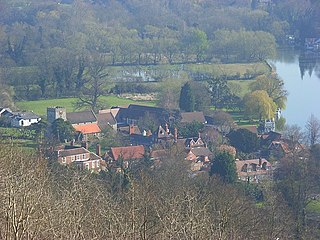
Streatley is a village and civil parish on the River Thames in Berkshire, England. The village faces Goring-on-Thames. The two places share in their shops, services, leisure, sports and much of their transport. Across the river is Goring & Streatley railway station and the village cluster adjoins a lock and weir. The west of the village is a mixture of agriculture and woodland plus a golf course. The village has a riverside hotel. Much of Streatley is at steeply varying elevations, ranging from 51m AOD to 185m at Streatley Warren, a hilltop point on its western border forming the eastern end of the Berkshire Downs. This Area of Outstanding Natural Beauty is topped by the 87-mile The Ridgeway path, which crosses the Thames at Goring and Streatley Bridge.

<span class="mw-page-title-main">Teddington Lock</span> Series of locks on the River Thames in London

Teddington Lock is a complex of three locks and a weir on the River Thames between Ham and Teddington in the London Borough of Richmond upon Thames, England. Historically in Middlesex, it was first built in 1810.

<span class="mw-page-title-main">Marsh Lock</span> Lock and weir on the River Thames in Berkshire, England

Marsh Lock is a lock and weir situated on the River Thames in England, about 1 mile upstream of Henley Bridge in Henley-on-Thames, Oxfordshire. The lock is close to the Berkshire bank, but accessed from the Oxfordshire side via two long walkways, the downstream one being near Mill Meadows. The first pound lock was built by the Thames Navigation Commission in 1773.

<span class="mw-page-title-main">Bray Lock</span> Lock and weir on the River Thames in Buckinghamshire, England

Bray Lock is a lock and weir on the River Thames in England near Bray and Dorney Reach, and is just above the M4 Bridge across the Thames. The lock is on the Buckinghamshire side of the river on the opposite bank from Bray itself and Maidenhead which are in Berkshire. Here, the county line stands roughly halfway between the lock and the opposite bank, following the course of the Thames itself. The pound lock was built by the Thames Navigation Commission relatively late, in 1845. The lock keeper's cottage is on an island between the lock and the weir.

<span class="mw-page-title-main">Whitchurch Lock</span> Lock and weir on the River Thames in Oxfordshire, England

Whitchurch Lock is a lock and weir on the River Thames in England. It is a pound lock, built by the Thames Navigation Commissioners in 1787. It is on an island near the Oxfordshire village of Whitchurch-on-Thames and is accessible only by boat.

<span class="mw-page-title-main">Shiplake Lock</span> Lock on the River Thames in Oxfordshire, England

Shiplake Lock is a lock and weir situated on the River Thames in England between the villages of Shiplake and Lower Shiplake, Oxfordshire. It is just above the points where the River Loddon joins the Thames and Shiplake Railway Bridge crosses the river. The first pound lock was built by the Thames Navigation Commission in 1773.

<span class="mw-page-title-main">Goring Lock</span> Lock and weir on the River Thames in Oxfordshire, England

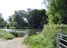
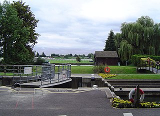
Goring Lock is a lock and weir situated on the River Thames in England at the Goring Gap in the Chiltern Hills. The lock is located on the Oxfordshire bank at Goring-On-Thames, with Streatley, Berkshire on the opposite side of the river. It is just upstream of Goring and Streatley Bridge. The lock was first built in 1787 by the Thames Navigation Commissioners

<span class="mw-page-title-main">Cookham Lock</span> Lock and weirs on the River Thames in Berkshire, England

Cookham Lock is a lock with weirs situated on the River Thames near Cookham, Berkshire, about a half-mile downstream of Cookham Bridge. The lock is set in a lock cut which is one of four streams here and it is surrounded by woods. On one side is Sashes Island and on the other is Mill Island connected to Formosa Island, the largest on the non-tidal Thames.

<span class="mw-page-title-main">Thames Path</span> National Trail following the River Thames in England

The Thames Path is a National Trail following the River Thames from one of its sources near Kemble in Gloucestershire to the Woolwich foot tunnel, south east London. It is about 185 miles (298 km) long. A path was first proposed in 1948 but it only opened in 1996.

<span class="mw-page-title-main">Hambleden Lock</span> Lock on the River Thames in Berkshire, England

Hambleden Lock is a lock with a long weir situated on the River Thames in England, about 2 miles downstream of Henley Bridge. The lock is on the Berkshire bank between Aston and Remenham. Built by the Thames Navigation Commission in 1773, the lock is named after the village of Hambleden, a mile (1.5 km) to the north.

<span class="mw-page-title-main">Iffley Lock</span> Lock on the River Thames in Oxfordshire, England

Iffley Lock is a lock on the River Thames in England near the village of Iffley, Oxfordshire. It is on the southern outskirts of Oxford. The original lock was built by the Oxford-Burcot Commission in 1631 and the Thames Navigation Commission replaced this in 1793. The lock has a set of rollers to allow punts and rowing boats to be moved between the water levels.

<span class="mw-page-title-main">Shepperton Lock</span> Lock on the River Thames in Surrey, England

Shepperton Lock is a lock on the River Thames, in England by the left bank at Shepperton, Surrey. It is across the river from Weybridge which is nearby linked by a passenger ferry.

<span class="mw-page-title-main">Benson Lock</span> Lock on the River Thames in Oxfordshire, England

Benson Lock is a lock on the River Thames in England, close to Benson, Oxfordshire but on the opposite bank of the river. The first pound lock here was built by the Thames Navigation Commission in 1788 and it was replaced by the present masonry lock in 1870. The distance between Benson Lock and Cleeve Lock downstream is 6.5 miles (10.4 km) - the longest distance between locks on the River Thames.

<span class="mw-page-title-main">Marlow Lock</span> Lock and weir on the River Thames in Buckinghamshire, England

Marlow Lock is a lock and weir situated on the River Thames in the town of Marlow, Buckinghamshire, England, about 300m downstream of Marlow Bridge. The first pound lock was built by the Thames Navigation Commission in 1773.

<span class="mw-page-title-main">Sunbury Lock</span> Lock on the River Thames in Surrey, England

Sunbury Lock is a lock complex of the River Thames in England near Walton-on-Thames in north-west Surrey, the third lowest of forty four on the non-tidal reaches. The complex adjoins the right, southern bank about 12 mile (0.80 km) downstream of the Weir Hotel.

<span class="mw-page-title-main">Chertsey Lock</span> Lock on the River Thames in Surrey, England

Chertsey Lock is a lock on the River Thames in England, against the left bank, an area of Green Belt including Laleham Park, the largest public park in Spelthorne. It faces the town of Chertsey and is the fifth-lowest of the forty-four locks along the non-tidal course of the river. Owing to a course alteration both banks at the site of the lock have been since medieval times in Surrey. Stone-built Chertsey Bridge built in 1785 is 210 m south (downstream) of the lock. The lock was built by the City of London Corporation in 1813, lengthened in 1893 and again in 1913.

<span class="mw-page-title-main">Penton Hook Lock</span> Lock on the River Thames in Surrey, England

Penton Hook Lock is the sixth lowest lock of forty four on the non-tidal reaches of the River Thames in England. It faces an island which was until its construction a pronounced meander and is on the site of its seasonal cutoff. It is against the left bank marking the church parish medieval border of Laleham and Staines upon Thames in Surrey for many centuries. Until 1965 their county was Middlesex. At 266 ft (81 m) it is the third longest lock on the river.

<span class="mw-page-title-main">Boveney Lock</span> Lock on the River Thames in Buckinghamshire, England

Boveney Lock is a lock on the River Thames situated on the Buckinghamshire bank opposite the Windsor Racecourse and close to Eton Wick. Boveney is a village a little way upstream on the same side. The lock was first built in 1838 by the Thames Navigation Commission. The lock was rebuilt in 1898 closer to the Buckinghamshire bank, and a set of boat rollers were installed on the old site.

Chalmore Lock was a lock and weir which operated between 1838 and 1883 on the River Thames in England near Wallingford, Oxfordshire.

References

  1. 1 2 3 "Environment Agency Dimensions of locks on the River Thames". web page. Environmental Agency. 8 November 2012. Retrieved 17 November 2012. Dimensions given in metres
  2. "Towns and Villages around Reading". Visitor UK. Retrieved 28 June 2021.
  3. Draper, Simon. "Goring Introduction: Landscape, Settlement, and Buildings" (PDF). Institute of Historical Research. Retrieved 28 June 2021.
  4. 1 2 Fred. S. Thacker The Thames Highway: Volume II Locks and Weirs 1920 - republished 1968 David & Charles
  5. Paul Goldsack River Thames: In the footsteps of the famous English Heritage/Bradt 2003
  6. 1 2 "Environment Agency Distances between locks on the River Thames". web page. Environmental Agency. 19 November 2012. Retrieved 20 November 2012. Distances given in km