Moulsford Railway Bridge

Last updated

Moulsford Railway Bridge
MoulsfordRlyBr01.JPG
Moulsford Railway Bridge (original) from downstream
Coordinates 51°33′29″N1°08′33″W / 51.55806°N 1.14250°W / 51.55806; -1.14250
Carries Great Western Main Line
Crosses River Thames
Locale Moulsford
Maintained by Network Rail
Heritage statusGrade II* listed
Characteristics
Design Skew arch
MaterialBrick
Height21 feet 8 inches (6.60 m) [1]
No. of spans4
Piers in water3
Rail characteristics
No. of tracks 4
Track gauge 1,435 mm (4 ft 8+12 in)
Electrified 25 kV 50 Hz AC OHLE
History
Designer Isambard Kingdom Brunel
Opened1839 and 1892
Location
Moulsford Railway Bridge

Moulsford Railway Bridge, also known locally as "Four Arches" bridge, [2] is a pair of parallel bridges located a little to the north of Moulsford and South Stoke in Oxfordshire, UK. It carries the Great Western Main Line from Paddington, London to Wales and the West across the River Thames. The bridge lies between the stations at Goring & Streatley and Cholsey, and crosses the Thames at an oblique angle on the reach between Cleeve Lock and Benson Lock.

Contents

The original Moulsford Railway Bridge was built between 1838 and 1840, having been designed by Isambard Kingdom Brunel for the main trunk route of the Great Western Railway. Built to carry a pair of broad gauge tracks across the Thames, it consists of four low semi-elliptical arches spanning the Thames at a considerably skewed angle of 60 degrees. During the 1890s, a second bridge was built immediately parallel to the original structure, enabling the railway to be expanded to a quadruple track configuration. The bridge was subsequently recognised as a Grade II* listed structure. [3] During the 2010s, the lines across the structure were electrified

Construction

First bridge

The original Moulsford Railway Bridge was built to carry the main line of the Great Western Railway (GWR) over the River Thames. [3] Construction of this truck line between London and Bristol had been authorised by an Act of Parliament in 1835, with construction commencing during the following year. The bridge, along with many of the railway's engineering features, was designed by the accomplished engineer Isambard Kingdom Brunel, who was the leading figure in the GWR's engineering and management. [3] [4]

The bridge, which was built to carry a pair of broad gauge tracks, was a relatively ambitious design, consisting of four elliptical skew arches of 62 feet (19 m) span and a headway height of 21 feet 8 inches (6.60 m). [3] Consisting primarily of red brick with Bath stone quoins, it is skewed at an angle of 60 degrees to the river. The structure has often been regarded as being of an exceptional size for the era; to better accommodate such dimensions, Brunel incorporated a series of internal longitudinal walls and voids to lighten the superstructure, which also reduced the cost and time needed to construct it. [3] It has been alleged that the GWR had promised the Bishop of Durham to aesthetically embellish the bridge to mollify his doubts of the scheme. [5] Historic England has observed the bridge to be one of the most impressive structures along the whole length of the railway. [3]

Construction of the Moulsford Railway Bridge occurred between 1838 and 1840, having been built at the same time as several other railway bridges on the line, including those at Maidenhead and Gatehampton; furthermore, design features are shared between these three bridges. [3] Relatively little alterations have been performed to the structure since its original opening to traffic, even the construction of a second bridge alongside did not result in significant changes to the original bridge, the two structures remaining distinct separate identities. Since the building of the second bridge, the first has been often referred to as the 'west' or 'fast' bridge. [3]

Second bridge

Moulsford Railway Bridge from the upstream side, the newest is closest Moulsford Railway Bridge from upstream on the Stoke side.jpg
Moulsford Railway Bridge from the upstream side, the newest is closest
The bridges from underneath; the original is closest MoulsfordRailwayBridgeUnderside.jpg
The bridges from underneath; the original is closest

By the 1870s, capacity along the railway was becoming noticeably constrained by a lack of capacity, leading to pressure to widen the line wherever possible. [3] During 1892, the section of the line around the bridge was expanded to a quadruple track arrangement; to accommodate this, the construction of a second bridge was necessary. It was built alongside the upstream side of the original, being connected to it by a series of girders and brick bridgelets. [3] [6] The two bridges are also joined together at the deck level by a series of vaulted brick footbridges. [3] [7]

The design of the second bridge was, like many other structures built for the expansion, was intentionally designed to be sympathetic to Brunel's original bridge; thus, it shares many similarities, such as identical profile and dimensions, to the first bridge. [3] It also has several differences, such as the lack of stone quoins, while the plain uncut bricks form a jagged pattern where they meet the faces of the bridge. The second bridge is also somewhat narrower than the first, having been built to carry a pair of standard gauge tracks. [3]

In relation to the original bridge, it is often referred to as the 'east' or 'relief' bridge. The second bridge has typically been regarded as possessing less intrinsic merit than the first one. [3]

Alterations

During the 1970s, the Great Western Main Line was subject to extensive reengineering work to enable 125 MPH running for the newly introduced Intercity 125 services; accordingly, some changes were made to Moulsford Railway Bridge. Work on constructing safety refuges commenced, despite protection from preservation orders and objections filed by council authorities; British Rail's chief engineering at Reading was allegedly unhappy with the work, resulting in alternative plans being filed and subsequently enacted. [5] Between March and July 2016, national rail infrastructure owner Network Rail commissioned contractors to perform repairs and cleaning activities to the two bridges; this involved the temporary staged closure of each arch to river traffic. [8]

During the 2010s, the railway lines crossing the bridge were electrified, requiring the installation of 25 kV 50 Hz AC OHLE across the structure. Members of the public voiced concerns over the aesthetic impact of such modifications to the structure; [5] for its part, Network Rail commissioned studies into minimising the visual impact of the electrification effort. [9]

See also

Related Research Articles

<span class="mw-page-title-main">Bristol Temple Meads railway station</span> Major railway station for the city of Bristol, England

Bristol Temple Meads is the oldest and largest railway station in Bristol, England. It is located 118 miles 31 chains away from London Paddington. It is an important transport hub for public transport in the city; there are bus services to many parts of the city and surrounding districts, with a ferry to the city centre. Bristol's other major station, Bristol Parkway, is a more recent station on the northern outskirts of the conurbation.

<span class="mw-page-title-main">Great Western Railway</span> British railway company (1833–1947)

The Great Western Railway (GWR) was a British railway company that linked London with the southwest, west and West Midlands of England and most of Wales. It was founded in 1833, received its enabling act of Parliament on 31 August 1835 and ran its first trains in 1838 with the initial route completed between London and Bristol in 1841. It was engineered by Isambard Kingdom Brunel, who chose a broad gauge of 7 ft —later slightly widened to 7 ft 14 in —but, from 1854, a series of amalgamations saw it also operate 4 ft 8+12 in standard-gauge trains; the last broad-gauge services were operated in 1892.

<span class="mw-page-title-main">Box Tunnel</span> Railway tunnel in western England

Box Tunnel passes through Box Hill on the Great Western Main Line (GWML) between Bath and Chippenham. The 1.83-mile (2.95 km) tunnel was the world's longest railway tunnel when it was completed in 1841.

<span class="mw-page-title-main">Great Western Main Line</span> Important railway corridor in England, UK

The Great Western Main Line (GWML) is a main line railway in England that runs westwards from London Paddington to Bristol Temple Meads. It connects to other main lines such as those from Reading to Penzance and Swindon to Swansea. Opened in 1841, it was the original route of the first Great Western Railway which was merged into the Western Region of British Railways in 1948. It is now a part of the national rail system managed by Network Rail with the majority of passenger services provided by the current Great Western Railway franchise.

<span class="mw-page-title-main">Maidenhead Railway Bridge</span> Railway bridge designed by I.K.Brunel in Maidenhead, England

Maidenhead Railway Bridge, also known as Maidenhead Viaduct and The Sounding Arch, carries the Great Western Main Line (GWML) over the River Thames between Maidenhead, Berkshire and Taplow, Buckinghamshire, England. It is a single structure of two tall wide red brick arches buttressed by two over-land smaller arches. It crosses the river on the Maidenhead-Bray Reach which is between Boulter's Lock and Bray Lock and is near-centrally rooted in the downstream end of a very small island.

<span class="mw-page-title-main">Bath Spa railway station</span> British railway station in Bath, England

Bath Spa railway station is the principal station serving the city of Bath in South West England. It is on the Great Western Main Line, 106 miles 71 chains down the line from the zero point at London Paddington between Chippenham to the east and Oldfield Park to the west. Its three-letter station code is BTH.

<span class="mw-page-title-main">Gatehampton Railway Bridge</span> Bridge in Lower Basildon, Berkshire

Gatehampton Railway Bridge, otherwise referred to as Gatehampton Viaduct, is a railway bridge carrying the Great Western Main Line over the River Thames in Lower Basildon, Berkshire, England. It takes the line between the stations at Goring and Streatley and Pangbourne, and crosses the Thames on the reach between Whitchurch Lock and Goring Lock.

<span class="mw-page-title-main">Isambard Kingdom Brunel</span> British mechanical and civil engineer (1806–1859)

Isambard Kingdom Brunel was a British civil engineer and mechanical engineer who is considered "one of the most ingenious and prolific figures in engineering history", "one of the 19th-century engineering giants", and "one of the greatest figures of the Industrial Revolution, [who] changed the face of the English landscape with his groundbreaking designs and ingenious constructions". Brunel built dockyards, the Great Western Railway (GWR), a series of steamships including the first purpose-built transatlantic steamship, and numerous important bridges and tunnels. His designs revolutionised public transport and modern engineering.

<span class="mw-page-title-main">Loughor Viaduct</span> Bridge over River Loughor, south Wales

The Loughor railway viaduct carries the West Wales Line across the River Loughor. It is adjacent, and runs parallel to, the Loughor road bridge. The 1880 viaduct was granted Grade II listed building status. Before it was demolished in early 2013, the viaduct was the last remaining timber viaduct designed by Isambard Kingdom Brunel.

<span class="mw-page-title-main">Usk Railway Bridge</span> Bridge in Newport

The Usk Railway Bridge is a railway viaduct in Newport city centre, Wales. It crosses the River Usk in an east—west direction, carrying the Great Western Main Line.

<span class="mw-page-title-main">Windsor Railway Bridge</span> Bridge in Windsor

Windsor Railway Bridge is a wrought iron 'bow and string' bridge in Windsor, Berkshire, crossing the River Thames on the reach between Romney Lock and Boveney Lock. It carries the branch line between Slough and Windsor.

<span class="mw-page-title-main">Moulsford</span> Human settlement in England

Moulsford is a village and civil parish in South Oxfordshire. Before 1974 it was in the county of Berkshire, in Wallingford Rural District, but following the Berkshire boundary changes of that year it became a part of Oxfordshire. Moulsford is on the A329, by the River Thames, just north of Streatley and south of Wallingford. The west of the parish is taken up by the foothills of the Berkshire Downs, including the Moulsford Downs. Moulsford Bottom and Kingstanding Hill are traditionally associated with King Alfred and the Battle of Ashdown.

<span class="mw-page-title-main">Bourne End Railway Bridge</span> Bridge in Bourne End, Buckinghamshire

Bourne End Railway Bridge is a railway bridge carrying the Marlow Branch Line, and a footpath over the River Thames in Bourne End, Buckinghamshire, England. It crosses the Thames on the reach between Cookham Lock and Marlow Lock.

<span class="mw-page-title-main">Avon Bridge</span> Bridge in Bristol, England

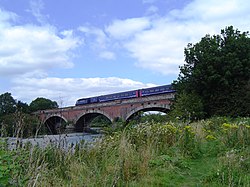
The Avon Bridge is a railway bridge over the River Avon in Brislington, Bristol, England. It was built in 1839 by Isambard Kingdom Brunel and has been designated by Historic England as a Grade I listed building. The contract was originally awarded to William Ranger, who fell behind with the build and had his construction plant seized so the Great Western Railway company could finish construction. Ranger started legal proceedings against the company, but they were eventually quashed by Lord Cranworth.

<span class="mw-page-title-main">Wharncliffe Viaduct</span> Bridge in Hanwell, London

The Wharncliffe Viaduct is a brick-built viaduct that carries the Great Western Main Line railway across the Brent Valley, between Hanwell and Southall, Ealing, UK, at an elevation of 20 metres (66 ft). The viaduct, built in 1836–7, was constructed for the opening of the Great Western Railway (GWR). It is situated between Southall and Hanwell stations, the latter station being only a very short distance away to the east.

<span class="mw-page-title-main">Skew arch</span> Method of construction

A skew arch is a method of construction that enables an arch bridge to span an obstacle at some angle other than a right angle. This results in the faces of the arch not being perpendicular to its abutments and its plan view being a parallelogram, rather than the rectangle that is the plan view of a regular, or "square" arch.

<span class="mw-page-title-main">Moulsford railway station</span> Former railway station in England

Moulsford railway station was on the original route of the Great Western Railway, being one of three intermediate stations provided when the line was extended from Reading to Steventon in 1840.

<span class="mw-page-title-main">Brentford branch line</span> Freight-only branch railway line in west London, England

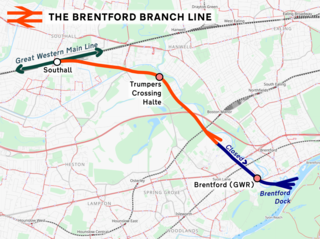
The Brentford branch line, also known as the Brentford Dock Line, is a freight-only branch railway line in west London, England. The route, which opened in 1859, was backed by the Great Western Railway and built by the Great Western & Brentford Railway Company. It ran 4 mi (6.4 km) from Southall to Brentford Dock. In 1964, the line to the wharves was closed. The branch now runs from the Great Western Main Line to a goods yard and waste transfer station in Brentford.

<span class="mw-page-title-main">Brentford Dock</span>

Brentford Dock in Brentford, west London, was a major trans-shipment point between the Great Western Railway (GWR) and barges on the River Thames. The building of Brentford Dock was started in 1855 and it was formally opened in 1859. The former dock yard was redeveloped in 1972 and is now Brentford Dock Marina and Brentford Dock Estate.

<span class="mw-page-title-main">Flying arch</span>

A flying arch is a form of arch bridge that does not carry any vertical load, but is provided solely to supply outward horizontal forces, to resist an inwards compression. They are used across cuttings, to avoid them collapsing inwards.

References

  1. "Bridge heights on the River Thames". River Thames Alliance. January 2008. Archived from the original on 24 January 2008.
  2. "The Cholsey Parish Plan" (PDF). Cholsey Parish Council. 2006. Retrieved 28 December 2009.[ permanent dead link ]
  3. 1 2 3 4 5 6 7 8 9 10 11 12 13 14 Historic England. "Moulsford Viaduct (MLN14730) (1285970)". National Heritage List for England . Retrieved 9 April 2016.
  4. "Brunel Engineering". momentousbritain.co.uk. Retrieved 15 August 2020.
  5. 1 2 3 "Your letters: Beautiful bridges". Henley Standard. 8 April 2015.
  6. "Moulsford Railway Bridge". thames.me.uk. Retrieved 15 August 2020.
  7. "Moulsford railway bridge crossing the Thames below Goring: detail of the arches". architecture.com. Retrieved 15 August 2020.
  8. "Moulsford Railway Bridge repair works" (PDF). assets.publishing.service.gov.uk. 19 March 2016.
  9. "Options to Improve Visual Amenity of Electrification: Phase 1 Output Report – Preliminary Review of Options W1001K-BBR-REP-EOH-000001-A01" (PDF). Network Rail. 31 May 2016.
Next crossing upstream River Thames Next crossing downstream
Winterbrook Bridge Moulsford Railway Bridge
Grid reference SU5953984714
Goring and Streatley Bridge