
The Ridgeway is a ridgeway or ancient trackway described as Britain's oldest road. The section clearly identified as an ancient trackway extends from Wiltshire along the chalk ridge of the Berkshire Downs to the River Thames at the Goring Gap, part of the Icknield Way which ran, not always on the ridge, from Salisbury Plain to East Anglia. The route was adapted and extended as a National Trail, created in 1972. The Ridgeway National Trail follows the ancient Ridgeway from Overton Hill, near Avebury, to Streatley, then follows footpaths and parts of the ancient Icknield Way through the Chiltern Hills to Ivinghoe Beacon in Buckinghamshire. The National Trail is 87 miles (140 km) long.

Wallingford is a historic market town and civil parish on the River Thames in South Oxfordshire, England, 12 miles (19 km) north of Reading, 13 miles (21 km) south of Oxford and 11 miles (18 km) north west of Henley-on-Thames. Although belonging to the historic county of Berkshire, it is within the ceremonial county of Oxfordshire for administrative purposes as a result of the 1972 Local Government Act. The population was 11,600 at the 2011 census.

Teddington Lock is a complex of three locks and a weir on the River Thames between Ham and Teddington in the London Borough of Richmond upon Thames, England. Historically in Middlesex, it was first built in 1810.

Marsh Lock is a lock and weir situated on the River Thames in England, about 1 mile upstream of Henley Bridge in Henley-on-Thames, Oxfordshire. The lock is close to the Berkshire bank, but accessed from the Oxfordshire side via two long walkways, the downstream one being near Mill Meadows. The first pound lock was built by the Thames Navigation Commission in 1773.

Bray Lock is a lock and weir on the River Thames in England near Bray and Dorney Reach, and is just above the M4 Bridge across the Thames. The lock is on the Buckinghamshire side of the river on the opposite bank from Bray itself and Maidenhead which are in Berkshire. Here, the county line stands roughly halfway between the lock and the opposite bank, following the course of the Thames itself. The pound lock was built by the Thames Navigation Commission relatively late, in 1845. The lock keeper's cottage is on an island between the lock and the weir.
This article lists the islands in the River Thames, or at the mouth of a tributary, in England. It excludes human-made islands built as part of the building of forty-five two-gate locks which each accompany a weir, and islets subordinate to and forming part of the overall shape of another. The suffix -ey is common across England and Scotland and cognate with ait and meaning island, a term – as ait or eyot – unusually well-preserved on the Thames. A small minority of list entries are referred to as Island, Ait or Eyot and are vestiges, separated by a depression in the land or high-water-level gully.

Crowmarsh Gifford, commonly known as Crowmarsh, is a village in the civil parish of Crowmarsh, in the South Oxfordshire district, in the county of Oxfordshire, England. It is beside the River Thames opposite the market town of Wallingford, the two linked by Wallingford Bridge. Crowmarsh parish also includes the hamlet of Newnham Murren, which is now merged with the village; the hamlet of Mongewell, and the village of North Stoke 2 miles (3.2 km) to the south.

Benson is a village and civil parish in South Oxfordshire, England. The 2011 Census gave the parish population as 4,754. It lies about a mile and a half north of Wallingford at the foot of the Chiltern Hills, where a chalk stream, Ewelme Brook, joins the River Thames next to Benson Lock.
Cholsey is a village and civil parish 2 miles (3 km) south of Wallingford in South Oxfordshire. In 1974 it was transferred from Berkshire to Oxfordshire, and from Wallingford Rural District to the district of South Oxfordshire. The 2011 Census recorded Cholsey's parish population as 3,457. Cholsey's parish boundaries, some 17 miles (27 km) long, reach from the edge of Wallingford into the Berkshire Downs. The village green is called "The Forty" and has a substantial and ancient walnut tree.

Cookham Lock is a lock with weirs situated on the River Thames near Cookham, Berkshire, about a half-mile downstream of Cookham Bridge. The lock is set in a lock cut which is one of four streams here and it is surrounded by woods. On one side is Sashes Island and on the other is Mill Island connected to Formosa Island, the largest on the non-tidal Thames.

The Thames Path is a National Trail following the River Thames from one of its sources near Kemble in Gloucestershire to the Woolwich foot tunnel, south east London. It is about 185 miles (298 km) long. A path was first proposed in 1948 but it only opened in 1996.

Wallingford Bridge is a medieval road bridge over the River Thames in England which connects Wallingford and Crowmarsh Gifford, Oxfordshire. It crosses the Thames on the reach between Cleeve Lock and Benson Lock. The bridge is 900 feet (270 m) long and has 19 arches. It is a scheduled monument. Since the construction of the southern Wallingford bypass in 1993, most traffic crossing the Thames at the town uses Winterbrook Bridge.

Molesey Lock is a lock on the River Thames in England at East Molesey, Surrey on the right bank.
Platt's Eyot or Platt's Ait is an island on the River Thames at Hampton, in the London Borough of Richmond upon Thames, England, on the reach between Molesey Lock and Sunbury Lock.

The A4130 is a British A road which runs from a junction with the A404 at Burchetts Green (Maidenhead), Berkshire to the A417 at Rowstock in Oxfordshire. It passes through Henley-on-Thames, and Nettlebed, and bypasses Wallingford and Didcot.

Shillingford is a hamlet on the north bank of the River Thames in Warborough civil parish in South Oxfordshire, England. It lies on the A4074 between Oxford and Reading, at the junction with the A329.
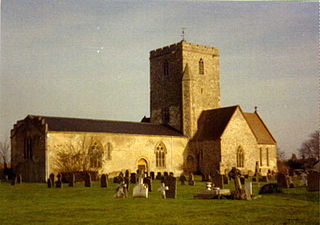
Mongewell is a village in the civil parish of Crowmarsh in the South Oxfordshire district, in Oxfordshire, England, about 1 mile (1.6 km) south of Wallingford. Mongewell is on the east bank of the Thames, linked with the west bank at Winterbrook by Winterbrook Bridge. The earthwork Grim's Ditch, now part of The Ridgeway long-distance footpath, passes through the northern part of it and is a scheduled ancient monument. It has a church called St John the Baptist's Church.

Shillingford Bridge is Grade II* listed road bridge near Shillingford, Oxfordshire, carrying an unclassified road across the River Thames in England on the reach above Benson Lock. The bridge provides access between Shillingford to the north of the river and Wallingford to the south. Originally the south side was in Berkshire but was transferred from Berkshire to Oxfordshire in 1974. The bridge is single track and vehicular passage is controlled by traffic lights.

Cleeve Lock is a lock on the River Thames, in Oxfordshire, England. It is located just upstream of Goring and Streatley villages, on the eastern side of the river within the village of Goring. There was a hamlet of Cleeve, after which the lock is named, but it dropped out of use, as always part of Goring.
Chalmore Lock was a lock and weir which operated between 1838 and 1883 on the River Thames in England near Wallingford, Oxfordshire.


