Chalk Farm is a small urban district of north London, lying immediately north of Camden Town, in the London Borough of Camden.

The New North Road is a road in northern central London, forming part of a link road from the A1 at Highbury into the City of London at Moorgate. It is 0.8 miles (1.3 km) in length and is part of the A1200. This link road consists of Canonbury Road and New North Road, before several smaller sections to the south leading into the city.

Ossington Street is a quiet one-way street in London, W2, leading from Moscow Road at its north end to the Bayswater Road / Notting Hill Gate at its south end.

Bayswater Road is the main road running along the northern edge of Hyde Park in London. Originally part of the A40 road, it is now designated part of the A402 road.

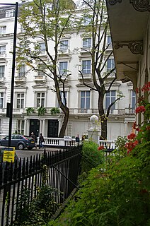
Lancaster Gate is a mid-19th century development in the Bayswater district of central London, immediately to the north of Kensington Gardens. It consists of two long terraces of houses overlooking the park, with a wide gap between them opening onto a square containing a church. Further terraces back onto the pair overlooking the park and loop around the square. Until 1865 the terraces were known as Upper Hyde Park Gardens, with the name Lancaster Gate limited to the square surrounding the church. The development takes its name from Lancaster Gate, a nearby entrance to Kensington Gardens, itself named in honour of Queen Victoria as Duke of Lancaster.
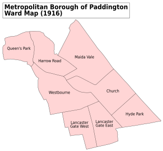
Westbourne is an area west of Paddington in west London. It has a manorial history spanning many centuries, within a more broadly defined Paddington, before shedding its association in the mid-19th century. It is named after the west bourne, West Bourne, or River Westbourne, a Thames tributary which was encased in 19th-century London in the 1850s. The spring-fed stream and associated manor have led to the place names Westbourne Green, Westbourne Park and more narrowly: Westbourne Gardens, Westbourne Grove, Westbourne Park Road, Westbourne Park tube station, Westbourne Studios and the name of a public house.

Elthorne was a hundred of the historic county of Middlesex, England.

Ossulstone is an obsolete subdivision (hundred) covering 26.4% of – and the most metropolitan part – of the historic county of Middlesex, England. It surrounded but did not include the City of London and the area has been entirely absorbed by the growth of London. It now corresponds to the seven London Boroughs of Inner London north of the Thames and, from Outer London, in decreasing order, certain historic parishes of the London boroughs of Ealing, Brent, Barnet, Hounslow and Haringey.

Leinster Gardens is a street in Bayswater, London. It is lined with tall, ornate, mid-Victorian terraced houses, many of which are listed buildings.

The New Road was a toll road built across fields around the northern boundaries of London, the first part of which opened in 1756. The route comprises the following modern-day roads: Old Marylebone Road, Marylebone Road, Euston Road, Pentonville Road, City Road, and Moorgate.
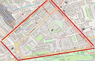
Craven Hill Gardens is a classical, Victorian, residential garden estate which has two small garden squares, the green subset of squares in London. It is in Bayswater, in its Lancaster Gate neighbourhood, south-west of contemporary Paddington of which those districts were once part. It is made up of four rows of residential buildings lining its three streets, and eastern returns, between 160 and 250 metres north of Hyde Park. The western return of this street configuration is partly Leinster Gardens and partly named Leinster Terrace.
Tyburnia is a part of Paddington created to an 1824 masterplan by Samuel Pepys Cockerell to redevelop the historic lands of the Bishop of London, known as the Tyburn Estate, into a residential area to rival Belgravia. It was the first part of Paddington to be developed.
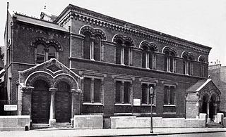
Bayswater Synagogue was an Ashkenazi-Orthodox synagogue located in Chichester Place, Paddington, London, near the Harrow Road. Built in 1863, as a branch synagogue jointly of the Great Synagogue and the New Synagogue, it was one of the original five synagogues that formed the United Synagogue in 1870. The original building was demolished in 1965 for construction of the Westway overpass and the Warwick Estate redevelopment.
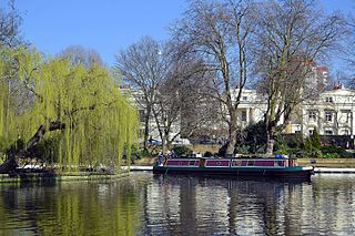
Little Venice is a district in West London, England, around the junction of the Paddington Arm of the Grand Union Canal, the Regent's Canal, and the entrance to Paddington Basin. The junction forms a triangular shape basin. Many of the buildings in the vicinity are Regency white painted stucco terraced town houses and taller blocks (mansions) in the same style. The area is 2.5 miles (4.0 km) west-north-west of Charing Cross and immediately north-west of Paddington.
The Hampstead Antiquarian and Historical Society was a local history society devoted to the history of Hampstead, London. Founded in 1897, the society first met at Hampstead Town Hall. The group was active until at least 1940 and published a journal known as the Transactions of the Hampstead Antiquarian and Historical Society.

Lissenden Gardens is a small inner urban area in north London in the London Borough of Camden at the very south east of Hampstead Heath.

Ealing Grove was a mansion and estate in Ealing, Middlesex, west London, England. It was adjacent to the Ealing House estate, but distinct from it, and stood amongst trees.

Warwick Crescent is a street in Little Venice, London. It connects Harrow Road with Westbourne Terrace Road, running along the southern edge of the Grand Union Canal.
Fritz Dupré was a London merchant of iron and manganese ores who became known as the "Manganese Ore King".
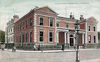
Paddington Town Hall was a municipal building in Harrow Road, Paddington, London. The structure, which was the headquarters of the Paddington Metropolitan Borough Council, was demolished in 1965.

