Essex County is located in the northeastern part of the U.S. state of New Jersey, and is one of the centrally located counties in the New York metropolitan area. As of the 2020 census, the county was the state's second-most populous county, with a population of 863,728, its highest decennial count since the 1970 census and an increase of 79,759 (+10.2%) from the 2010 census count of 783,969. The county is part of the North Jersey region of the state.
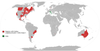
Little Italy is the catch-all name for an ethnic enclave populated primarily by Italians or people of Italian ancestry, usually in an urban neighborhood. The concept of "Little Italy" holds many different aspects of the Italian culture. There are shops selling Italian goods as well as Italian restaurants lining the streets. A "Little Italy" strives essentially to have a version of the country of Italy placed in the middle of a large non-Italian city. This sort of enclave is often the result of periods of Italian immigration, during which people of the same culture settled or were ostracized and segregated together in certain areas. As cities modernized and grew, these areas became known for their ethnic associations, and ethnic neighborhoods like "Little Italy" blossomed, becoming the areas they are today.
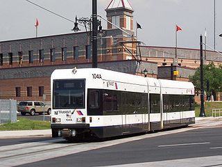
The Newark Light Rail (NLR) is a light rail system serving Newark, New Jersey, and surrounding areas, owned by New Jersey Transit and operated by its bus operations division. The service consists of two segments, the original Newark City Subway (NCS), and the extension to Broad Street station. The City Subway opened on May 26,1935, while the combined Newark Light Rail service was officially inaugurated on July 17, 2006.

University Heights is a neighborhood in Newark in Essex County, in the U.S. state of New Jersey. It is so named because of the four academic institutions located within its boundaries: Rutgers University, New Jersey Institute of Technology (NJIT), New Jersey Medical School (Rutgers) and Essex County College. In total, the schools enroll approximately 30,000 degree-seeking students.

Interstate 280 (I-280) is a 17.85-mile (28.73 km) Interstate Highway in the U.S. state of New Jersey. It provides a spur from I-80 in Parsippany–Troy Hills, Morris County, east to Newark and I-95 in Kearny, Hudson County. In Kearny, access is provided toward the Holland Tunnel and Lincoln Tunnel to New York City. The western part of the route runs through suburban areas of Morris and Essex counties, crossing the Watchung Mountains. Upon reaching The Oranges, the setting becomes more urbanized and I-280 runs along a depressed alignment before ascending again in Newark. I-280 includes a vertical-lift bridge, the William A. Stickel Memorial Bridge, over the Passaic River between Newark and East Newark/Harrison. The highway is sometimes called the Essex Freeway. I-280 intersects several roads, including the Garden State Parkway in East Orange and Route 21 in Newark.

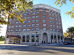
Broadway is a neighborhood within the city of Newark in Essex County, in the U.S. state of New Jersey. It is located on the west bank of the Passaic River, in Newark's North Ward, east of Forest Hill and north of Seventh Avenue. The neighborhood extends from Interstate 280 to Belleville. The term "Broadway" has only come into use recently, most Broadway residents simply refer to their area as part of the North Ward. The street itself "Broadway" was called "Washington Avenue" until the early twentieth century. Today, the area is predominantly Italian American, Puerto Rican and Dominican, with a growing population from other parts of Latin America. The New Jersey Historical Society was located here from the 1930s to 1997. The neo-classical Mutual Benefit building was constructed in the Broadway neighborhood in 1927. The district has many old brownstones in various states of repair. There are high-rise apartment buildings overlooking Branch Brook Park.
Roseville is a neighborhood in the city of Newark in Essex County, in the U.S. state of New Jersey. It borders Bloomfield and East Orange. To the neighborhood's immediate east is the Newark City Subway and Branch Brook Park. Roseville is divided into Upper Roseville north of 3rd Ave and Lower Roseville south of 3rd Ave.

Springfield/Belmont is a neighborhood in the city of Newark in Essex County, in the U.S. state of New Jersey. Part of the Central Ward, it is unofficially bounded by South Orange Avenue in the north, Avon Avenue in the south, Martin Luther King Boulevard and University Avenue on the east, and Bergen Street in the west.

Fairmount is a neighborhood in the city of Newark in Essex County, in the U.S. state of New Jersey. It is part of the West Ward. Its population is mostly African American. Central Avenue is the major street, though its commerce is considerably reduced from the Industrial Era heyday. The neighborhood is bounded by South Orange Avenue on the south, the Garden State Parkway on the west, Interstate 280 on the north, West Market Street on the north-east, and the University of Medicine and Dentistry of New Jersey on the east.

East Rock is a neighborhood in the city of New Haven, Connecticut, named for nearby East Rock, a prominent trap rock ridge. The area is home to a large group of Yale students, staff, and faculty, as well as many young professionals and families.
The West Side is a neighborhood in the city of Newark in Essex County, in the U.S. state of New Jersey. It is bounded on the east by Bergen Street, on the south by Rose Terrace and Avon Avenue, on the west by Irvington and on the north by South Orange Avenue. The main roads running through the neighborhood are Bergen Street, South Orange Avenue and Springfield Avenue. The mostly residential neighborhood is home to Woodland Cemetery and West Side Park. West Side High School and Chad Science Academy (7-12) are also in this neighborhood. The area between 14th Street, 17th Avenue, 12th Avenue and Avon Avenue, once called Wolf's Harbor, is now the area around West Side Park. The area of Wolf's Harbor was once a large marsh that was home to several wolves. The area was renamed Magnolia Swamp after the tree when the wolves disappeared from the swamp. The swamp was filled in over time and eventually 14th Street cut through the middle of it after land was repeatedly filled in by Edward Keogh. West Side Park, a county run park, was originally situated on a hill full of linden trees overlooking a lake, but the lake was later filled in to accommodate fields. Today the west side of the park remains elevated over the clear flat east side of the park and the hill was once used for skiing. There were once performances at the park, including Dionne Warwick and Whitney Houston.

Lincoln Park is a city square and neighborhood, also known as "the Coast," in Newark, Essex County, New Jersey, United States. It is bounded by the Springfield/Belmont, South Broad Valley, South Ironbound and Downtown neighborhoods. It is bounded by Martin Luther King Jr. Blvd. to the west, West Kinney St. to the north, the McCarter Highway to the east and South St., Pennsylvania Avenue, Lincoln Park and Clinton Avenue to the south. Part of the neighborhood is a historic district listed on the New Jersey Register of Historic Places and the National Register of Historic Places. Lincoln Park as a street turns into Clinton Avenue toward the south and north edge of the park.
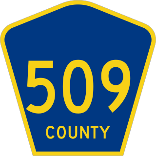
County Route 509 is a county highway in the U.S. state of New Jersey. The highway exists in two segments– one 0.95-mile (1.53 km) unsigned segment exists in northern Middlesex County while the signed mainline extends 25.78 miles (41.49 km) from North Avenue in Westfield to Straight Street in Paterson.

The members of the New Jersey Legislature are chosen from 40 electoral districts. Each district elects one senator and two assemblymen.

Weequahic is a neighborhood in the city of Newark in Essex County, in the U.S. state of New Jersey. Part of the South Ward, it is separated from Clinton Hill by Hawthorne Avenue on the north, and bordered by the township of Irvington on the west, Newark Liberty International Airport and Dayton on the east, and Hillside Township and the city of Elizabeth on the south. There are many well maintained homes and streets. Part of the Weequahic neighborhood has been designated a historic district; major streets are Lyons Avenue, Bergen Street, and Chancellor Avenue. Newark Beth Israel Medical Center is a major long-time institution in the neighborhood.

Vailsburg is a neighborhood in the city of Newark in Essex County, in the U.S. state of New Jersey. Part of the West Ward, its elevation is 280 feet (85 m). As of 2000, Vailsburg had a population of 34,348. The Vailsburg section of Newark is on a hill which closely aligns with the suburban and park areas outside it. Vailsburg includes the two smaller neighborhoods of upper Vailsburg and lower Vailsburg, both of which have Sanford Avenue as a focal point. Upper Vailsburg is closer to Maplewood and South Orange.
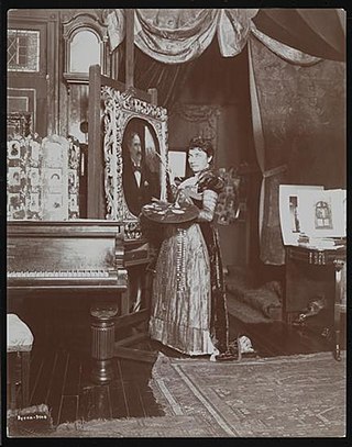
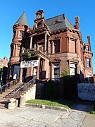
Mary Elizabeth Tillinghast was an American artist. Best known for stained glass, her professional career encompassed roles as architect, muralist, mosaic artist, textile artist, inventor, writer, and studio boss.
 St Andrews
 Bnai Abraham Deliverance Temple, a former synagogue on Clinton Avenue
 Clinton at Shanley Street