
Clio Channel is a marine waterway running southwest to northeast between Turnour and West Cracroft Islands in the Johnstone Strait region of the Central Coast of British Columbia, Canada. [1]
Clio Channel is a marine waterway running southwest to northeast between Turnour and West Cracroft Islands in the Johnstone Strait region of the Central Coast of British Columbia, Canada. [1]
Clio Channel was named c.1866 by Captain Pender for HMS Clio, which was commanded by Captain Nicholas E.B. Turnour, the namesake of Turnour Island, during the vessel's second commission with the Pacific Station of the Royal Navy from 1864 to 1868, [2] Clio Bay near Kitimat was also named for the Clio. [3]
Cormorant Channel Marine Provincial Park is a provincial park in British Columbia, Canada, located in the Pearse Islands, a small archipelago to the east of Cormorant Island and the Village of Alert Bay at the western end of Johnstone Strait.

The Gwa'Sala-Nakwaxda'xw Nations are a union of two Kwakwaka'wakw peoples in a band government based on northern Vancouver Island in British Columbia, Canada, whose main reserve community is near the town of Port Hardy in the Queen Charlotte Strait region of the Central Coast region of British Columbia, Canada. The band government is a member of the Kwakiutl District Council and, for treaty negotiation purposes, the Winalagalis Treaty Group which includes three other members of the Kwakiutl District Council.

Gilford Island is an island in British Columbia, Canada, between Tribune Channel and Knight Inlet. It has an area of 384 square kilometres (148 sq mi). Turnour Island is to its south, across Tribune Channel; and the entrance to Thompson Sound is to its east.
The Tlowitsis Nation, formerly the Klowitsis Tribe, the Turnour Island Band and the Tlowitsis-Mumtagila First Nation, is the Indian Act band government of the Ławit'sis (Tlowitsis) tribe of the Kwakwaka'wakw peoples, located in the Queen Charlotte Strait-Johnstone Strait area in the Discovery Islands between Vancouver Island and the British Columbia mainland in Canada. Ławit'sis territory covers parts of northern Vancouver Island, Johnstone Strait, and adjoining inlets of the mainland. Kalugwis, on Turnour Island, was their principal community in times past, but the band's offices are in the city of Campbell River to the southeast. Hanatsa IR No. 6 on Port Neville is the most populated of the band's Indian reserves.
Havannah Channel is a marine passageway in the South Coast region of British Columbia, Canada, leading off of the north side of Johnstone Strait leading to Chatham Channel and Call Inlet, south of East Cracroft Island. Havannah Channel is entered from Johnstone Strait at the Broken Islands. Hull Island is located in the channel, to the southeast of East Cracroft and south of the opening of Call Inlet.

Minstrel Island, is an island in the Johnstone Strait region of the Central Coast region of British Columbia, Canada. It is near the entrance to Knight Inlet just east of Turnour Island at the junction of Clio and Chatham Channels. The island is separated on its south from East Cracroft Island by a marine passageway called The Blow Hole.
Tribune Channel is a channel or strait on the Central Coast of British Columbia, Canada, separating Gilford Island on the west and north from the mainland. The channel bends around Gilford Island, with the mouth of Thompson Sound at the elbow of the bend, opening eastwards to the mouth of the Kakweiken River.
The Pearse Islands are a small group of islands in the Queen Charlotte Strait region of the Central Coast of British Columbia, Canada. They are just east of Cormorant Island, which is the location of the Village of Alert Bay. Cormorant Channel Marine Provincial Park is located in this group of islands.
Harbledown Island is an island in the Central Coast region of British Columbia, Canada, located west of West Cracroft Island. It is at the west end of Johnstone Strait and lies at the eastern edge of the Queen Charlotte Strait region. Hanson Island is to its west, West Cracroft Island to the south and southeast, across Baronet Passage, and Turnour Island to the northwest, across Beware Passage.
Kalugwis, or Karlukwees or Qalogwis, is the principal community of the Tlowitsis Nation of the Kwakwaka'wakw peoples of the Johnstone Strait region of the South Coast of British Columbia, Canada. It is located on the south shore of Turnour Island facing Beware Passage and is within Karlukwees Indian Reserve No. 1, a.k.a. Karlukwees 1, 10.8 ha.

Turnour Island is an island in the Johnstone Strait region of the Central Coast of British Columbia, located between Gilford Island and West Cracroft Island. On the other side Canoe Passage on its northwest is Village Island, while to its south and southwest is Beware Passage, across from which is Harbledown Island. Gilford Island is to the north across Tribune Channel. Separating Turnour from West Cracroft is Clio Channel.
Village Island is an island in the Johnstone Strait region of the Central Coast region of British Columbia, Canada, located on the northwest side of Turnour Island.
Eliot Passage is a marine waterway between Village Island (E) and Pearl Island (W) in the Johnstone Strait region of the Central Coast of British Columbia, Canada, southwest of the opening of Knight Inlet. The Kwakwaka'wakw village of Memkumlis, also known as Mamalillaculla after the name of the group of Kwakwaka'wakw whose principal village it is, is on its eastern shore on Village Island.
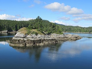
Klaoitsis Island, also perhaps Adlagamalla in Kwak'wala, is an island in the Johnstone Strait region of the Central Coast region of British Columbia, Canada. It is located to the south of Turnour Island in Clio Channel. The name is an alternate spelling of Ławit'sis or Tlowitsis, the name of the Kwakwaka'wakw group whose territory it is in.
Beware Passage is a strait or channel in the Central Coast region of British Columbia, Canada, between Harbledown (SE) and Turnour Islands. It was named in 1860 by Captain Pender.
Hull Island is an island in the Central Coast region of British Columbia, Canada, located in Havannah Channel to the east of the southern end of East Cracroft Island.
Bones Bay is located inside the territorial properties of the Namgiis indigenous peoples on a bay the north side of West Cracroft Island in the Johnstone Strait region of the Central Coast of British Columbia, Canada, on Clio Channel.
The Carey Group is a group of small islands in the Queen Charlotte Strait-Johnstone Strait region of the Central Coast of British Columbia, between Crease Island to the north-northwest and Harbledown Island to the south-southeast. It includes Ralph, Alder and Larsen Islands, and three small islands to the north of Larsen Island, including Madrona Island.
Drury inlet is an inlet in the Queen Charlotte Strait region of the Central Coast of British Columbia, Canada, extending west from Wells Passage to the northwest of North Broughton Island, northwest of the town of Port Hardy. Branching off to the northeast from the north side of the head of the inlet is Actaeon Sound.
Bonwick Island is an island in the Broughton Archipelago in Central Coast region of the Canadian province of British Columbia. The archipelago is on the northeast side of Queen Charlotte Strait and lies northwest of the village of Alert Bay and immediately to the west of Gilford Island, separated from it by Retreat Pass. Arrow Passage is to its northwest, separating it from Mars Island.
50°35′22″N126°24′09″W / 50.58944°N 126.40250°W
| | This article about a location on the Central Coast of British Columbia, Canada is a stub. You can help Wikipedia by expanding it. |