Related Research Articles
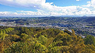
Whangārei is the northernmost city in New Zealand and the largest settlement of the Northland Region. It is part of the Whangarei District, created in 1989 from the former Whangārei City, Whangārei County and Hikurangi Town councils to administer both the city and its hinterland. The city population was estimated to be 56,800 in June 2024, an increase from 47,000 in 2001.

Dargaville is a town located in the North Island of New Zealand. It is situated on the bank of the Northern Wairoa River in the Kaipara District of the Northland region. Dargaville is located 55 kilometres (34 mi) southwest of Whangārei, and 174 kilometres (108 mi) north of Auckland.

Kaipara Harbour is a large enclosed harbour estuary complex on the north western side of the North Island of New Zealand. The northern part of the harbour is administered by the Kaipara District and the southern part is administered by the Auckland Council. The local Māori tribe is Ngāti Whātua.
Kaikohe is the seat of the Far North District of New Zealand, situated on State Highway 12 about 260 kilometres (160 mi) from Auckland, and about 85 kilometres (53 mi) from Whangārei. It is the largest inland town and highest community above sea level in the Northland Region. With a population of over 4000 people, Kaikohe is a shopping and service centre for an extensive farming district and is sometimes referred to as "the hub of the north".

Takapau is a small rural community in the Central Hawkes Bay in New Zealand. It is located 20 kilometres west of Waipukurau, off State Highway 2, and has a population of more than 500.

Wellsford is a town on the Northland Peninsula in the northern North Island of New Zealand. It is the northernmost major settlement in the Auckland Region, and is 77 kilometres (48 mi) northwest of the Auckland CBD. It is a major regional centre, being located at the junction of State Highways 1 and 16, almost halfway between Auckland and the Northland city of Whangārei.
Te Kao is a village on the Aupouri Peninsula of Northland, New Zealand. Te Aupōuri are mana whenua over Te Kao and the surrounding district, and it is the principal settlement of the iwi (tribe). Te Aupōuri's Post-Settlement Governance Entity, Te Runanga Nui o Te Aupōuri, has an office at Te Kao, along with the iwi's marae and urupa. State Highway 1 passes through the district. Cape Reinga is 46 km to the north, and Houhora is 24 km to the south. The Aupouri Forest and Ninety Mile Beach are to the west.

Whangape Harbour is a harbour on the west coast of Northland, New Zealand. There is a settlement called Whangape on the northern side of the harbour. Another, called Pawarenga, is located on the southern side. Kaitaia is 42 km north east.
Waikare is a locality in Northland, New Zealand. The Waikare River flows from the Russell Forest past Waikare and into the Waikare Inlet, which leads into the Bay of Islands.
Aranga is a locality in Northland, New Zealand. State Highway 12 passes through it. Ōmāpere is 47 km northwest, and Dargaville is 42 km southeast. The Waipoua Forest is to the north. Maunganui Bluff and the Tasman Sea are to the west, with the small settlement of Aranga Beach lying at the northern end of Ripiro Beach.
Arapohue is a locality in Northland, New Zealand, approximately 16 km south east of Dargaville
Kaihu is a locality and settlement in Northland, New Zealand. The Kaihu River runs through the Kaihu Valley into the Wairoa River near Dargaville, approximately 32 km south east. State Highway 12 runs along the valley and passes through Kaihu settlement. Aranga is about 10 km north west. The Kaihu Forest is to the east and the Marlborough Forest is to the north.
Kaiwaka, known as "the little town of lights", is a settlement in Northland, New Zealand. The Kaiwaka River runs from the east through the area and joins with the Wairau River to form the Otamatea River, which drains into the Kaipara Harbour. State Highway 1 passes through Kaiwaka. Wellsford is 20 kilometres (12 mi) south, Brynderwyn is 8 kilometres (5.0 mi) north, and Whangārei, the closest city, is 60 kilometres (37 mi) to the north. The Mangawhai Heads are 18 kilometres (11 mi) northeast of Kaiwaka.
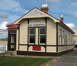
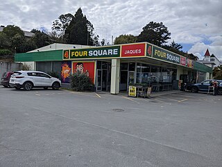
Matakohe is a settlement in Northland, New Zealand. The Matakohe River is a short river which runs from the north into the Arapaoa River, which is part of the Kaipara Harbour. State Highway 12 passes through Matakohe. Ruawai is 16 km to the west, and Paparoa is 6 km north east. The Hukatere Peninsula extends south into the Kaipara Harbour.
Te Kōpuru is the largest community on the Pouto Peninsula in Northland, New Zealand. The Wairoa River separates the peninsula at this point from the main North Auckland Peninsula to the east. Dargaville is 14 km (8.7 mi) to the north.

Hūkerenui is a settlement in Northland, New Zealand. State Highway 1 passes through the area. Kawakawa is northwest, and Hikurangi is southeast.
Mangatoki is a locality in southern Taranaki, in New Zealand's North Island. Eltham is to the east, Kaponga to the west and Matapu to the south. The Mangatoki Stream runs from Mount Taranaki through the area and into the Waingongoro River.
Tauhoa is a rural community in the Auckland Region of New Zealand's North Island.

Long Bay is one of the northernmost suburbs of the North Shore, part of the contiguous Auckland metropolitan area located in New Zealand.
Ihaia Te Ahu was a notable New Zealand teacher and missionary. Of Māori descent, he identified with the Te Uri Taniwha hapū of the Ngāpuhi iwi. He was born in Ōkaihau, Northland, New Zealand.
References
- ↑ Creech, Wyatt (17 September 1998). "Commissioner Appointed to Awarua School, Northland". New Zealand Government.
- ↑ "Northland school closing as it can't practise conversion therapy". One News. 12 March 2023.
- 1 2 3 4 5 6 7 8 9 10 11 12 "Mergers, Closures and New Schools, January 2005 - December 2005". Education Counts. Archived from the original (XLS) on 15 October 2008. Retrieved 24 May 2008.
- 1 2 3 "School Records [Whangape Native School]". Te Ahu Heritage Museum. Retrieved 31 March 2022.
- ↑ "About Us". Te Kura ā Iwi o Pawarenga. Retrieved 31 March 2022.
- ↑ "School records [Takahue School]". Te Ahu Heritage Museum. Retrieved 1 April 2022.
- ↑ Parata, Hekia (14 December 2016). "Te Kura Kaupapa Māori o Rangiawhia School (1141) Closure Notice". New Zealand Gazette.
- ↑ "About Us". Te Kura ā Iwi o Pawarenga. Retrieved 31 March 2022.
- 1 2 "Mergers, Closures and New Schools, January 2004 - January 2005". Education Counts. Archived from the original (XLS) on 15 October 2008. Retrieved 24 May 2008.
- 1 2 3 4 5 6 Gordon, Charles MacNeill (Mac) (2002). "Education Always a Priority". Pride of the Lion: Waipu - the People and the Place. pp. 191–2. ISBN 0-473-08890-8.
- ↑ "History". Hukerenui School Years 1–8. Archived from the original on 14 October 2008.
- ↑ Menefy, Diana (1988). Hukerenui... in the beginning. pp. 2, 55–6. ISBN 0-473-00641-3.
- ↑ Menefy, pp 2, 72-3
- ↑ Richards, Judy (1984). Ruakaka (A Brief History). pp. 80–81.
- 1 2 "School History". Matarau School. Archived from the original on 14 October 2008.
- ↑ McDonald, Ronald Derek (1962). Parakao School golden jubilee, 1912-1962.
- 1 2 3 "List of schools closed since 1/1/1999" (PDF).
- ↑ Menefy, pp 2, 95-98
- ↑ Richards, p 77
- 1 2 Menefy, pp 2, 67-71
- ↑ Richards, pp 81–83
- ↑ Menefy, pp 2, 76-9
- ↑ Gordon, pp 191-227
- ↑ Menefy, pp 2, 83-6, 90
- ↑ Menefy, pp 2, 87–89
- 1 2 3 4 5 6 7 8 9 10 11 12 13 Ryburn, Wayne (1999). Tall Spars, Steamers & Gum. p. 222. ISBN 0-473-06176-7.
- 1 2 3 4 5 6 7 8 9 10 11 12 13 14 Ryburn, p 167
- ↑ Cumming, Ian (1959). Glorious Enterprise: The History of the Auckland Education Board, 1857–1957. p. 332.
- ↑ Ryburn, p 165
- ↑ Bradley gives the closing date as 1965. Bradley, Edgar Kelsby (1982). The Great Northern Wairoa. p. 44.
- ↑ Bradley, p 112
- ↑ Bradley, p 114
- ↑ "The Te Roroa Report 1992". Waitangi Tribunal. Archived from the original on 15 October 2008. Retrieved 24 May 2008.
- ↑ Oruawharo School Jubilee Committee 1978. Oruawharo School 1928-1978.
{{cite book}}: CS1 maint: numeric names: authors list (link) - 1 2 3 Ryburn, p 168
- ↑ Bradley, p 132
- ↑ "POPULAR HEADMASTER". Auckland Star, Volume LIX, Issue 304, 24 December 1928, Page 8.
- ↑ "To school by motor-bus: the consolidation principle in operation". Kura Heritage Collections Online (Auckland Council Libraries). Retrieved 11 November 2024.
- ↑ Bradley says the school closed in 1928. p 47