
The River Weaver is a river, navigable in its lower reaches, running in a curving route anti-clockwise across west Cheshire, northern England. Improvements to the river to make it navigable were authorised in 1720 and the work, which included eleven locks, was completed in 1732. An unusual clause in the enabling Act of Parliament stipulated that profits should be given to the County of Cheshire for the improvement of roads and bridges, but the navigation was not initially profitable, and it was 1775 before the first payments were made. Trade continued to rise, and by 1845, over £500,000 had been given to the county.

Bishop's Castle is a market town in the south west of Shropshire, England. According to the 2011 Census it had a population of 1,893.

The Llangollen Canal is a navigable canal crossing the border between England and Wales. The waterway links Llangollen in Denbighshire, north Wales, with Hurleston in south Cheshire, via the town of Ellesmere, Shropshire. The name, which was coined in the 1980s, is a modern designation for parts of the historic Ellesmere Canal and the Llangollen navigable feeder, both of which became part of the Shropshire Union Canals in 1846.

Clun is a town in south west Shropshire, England, and the Shropshire Hills Area of Outstanding Natural Beauty. The 2011 census recorded 680 people living in the town. Research by the Campaign for the Protection of Rural England suggests that Clun is one of the "most tranquil" locations in England.
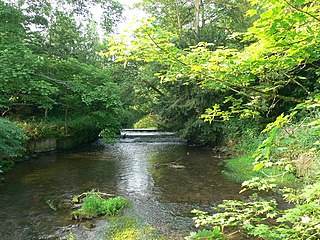
The River Clun runs mostly through Shropshire, England and joins the River Teme at Leintwardine, Herefordshire. The Clun Valley is part of the Shropshire Hills AONB.
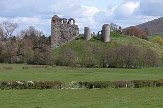
Clun Castle is a medieval ruined castle in Clun, Shropshire, England. Clun Castle was established by the Norman lord Robert de Say after the Norman invasion of England and went on to become an important Marcher lord castle in the 12th century, with an extensive castle-guard system. Owned for many years by the Fitzalan family, Clun played a key part in protecting the region from Welsh attack until it was gradually abandoned as a property in favour of the more luxurious Arundel Castle. The Fitzalans converted Clun Castle into a hunting lodge in the 14th century, complete with pleasure gardens, but by the 16th century the castle was largely ruined. Slighted in 1646 after the English Civil War, Clun remained in poor condition until renovation work in the 1890s.

Snailbeach District Railways was a British narrow gauge railway in Shropshire. It was built to carry lead ore from mines in the Stiperstones to Pontesbury where the ore was transshipped to the Great Western Railway's Minsterley branch line. Coal from the Pontesford coal mines travelled in the opposite direction. The line ended at Snailbeach, the location of Shropshire's largest and richest lead mine, though there had been a plan to extend it further, which would have brought it closer to more lead mines.
The Heart of Wales line is a railway line running from Craven Arms in Shropshire to Llanelli in southwest Wales. It serves a number of rural centres, including the nineteenth-century spa towns Llandrindod Wells, Llangammarch Wells and Llanwrtyd Wells. At Builth Road, two miles (3.3 km) from the town of Builth Wells, the line crosses the former route of the earlier Mid Wales Railway, which closed in 1962.

Clungunford is a village and civil parish in south Shropshire, England, located near the border with Herefordshire.
Historic ferries operated on rivers around Atlanta, Georgia area, and became namesakes for numerous current-day roads in north Georgia. Most of the ferries date to the early years of European-American settlement in the 1820s and 1830s, when parts of the region were still occupied by cherokee and other Native American communities.

New Invention is a hamlet in Shropshire, England on the A488 between Clun and Knighton. It comprises little more than four houses around a cross-roads and a neighbouring farm called The Weir, known in history as the Wear or Ware. Of the four houses, one was a blacksmith's shop, one a pub called the Stag's Head, and one a Methodist chapel built in 1874. It served as one of many local locations for the film Gone to Earth, directed by Michael Powell and Emeric Pressburger. The River Redlake passes through. The population as of the 2011 census is listed under Clun.
Ludford is a small village and civil parish in south Shropshire, England. The parish is situated adjacent to the market town of Ludlow and was, until 1895, partly in Herefordshire.

Cound is a village and civil parish on the west bank of the River Severn in the English county of Shropshire, about 7 miles south east of the county town Shrewsbury. Once a busy and industrious river port Cound has now reverted to a quiet rural community and dormitory village, for commuters to the commercial centres of Shrewsbury and Telford.
The Severn Valley is a rural area of the West Midlands region of England, through which the River Severn runs and the Severn Valley Railway steam heritage line operates, starting at its northernmost point in Bridgnorth, Shropshire and running south for 16 miles (26 km) to Ribbesford, a few miles south of Bewdley, Worcestershire in the Wyre Forest.

Cross Keys Bridge is a swing bridge that carries the busy single carriageway A17 road which runs from Newark in Nottinghamshire to King's Lynn in Norfolk over the tidal River Nene in Sutton Bridge in the extreme south east of Lincolnshire close to the borders of both Norfolk and Cambridgeshire and is a major landmark on the route particularly for holiday traffic heading into and out of Norfolk during the summer months.
The Middlewich Branch of the Shropshire Union Canal is located in Cheshire, in the north west of England, and runs between Middlewich, where it joins the Trent and Mersey Canal, and Barbridge Junction, where it joins the main line of the Shropshire Union Canal. It is 10 miles (16 km) long, and was planned as part of the Chester Canal, which was authorised in 1772, but the company ran out of money, and construction did not begin until 1827. The Trent and Mersey insisted that there should be no direct connection at Middlewich, and instead built the short Wardle Canal to join the two, charging large compensation tolls for traffic passing along it.

The Donnington Wood Canal was a 5.5-mile (8.9 km) private canal in East Shropshire, England, which ran from coal pits owned by Earl Gower at Donnington Wood to Pave Lane on the Wolverhampton to Newport Turnpike Road. It was completed in about 1767 and abandoned in 1904. The canal was part of a larger network of tub-boat canals, which were used for the transport of raw materials, particularly coal, limestone and ironstone, from the locations where they were mined to furnaces where the iron ore was processed. The canal was connected to the Wombridge Canal and the Shropshire Canal.
Cound Brook is a tributary of the River Severn in Shropshire, England, running to south of the county town Shrewsbury. The Cound Brook rises in the Stretton Hills, and enters the River Severn at Eyton on Severn after winding its way for 22 miles (35 km) across the southern Shropshire-Severn plain. This length is measured from high on the Long Mynd.
National Cycle Network Route 44, part of the National Cycle Network, connects Shrewsbury, Shropshire with Cinderford, Gloucestershire. The part of the route from Shrewsbury to Bromfield is signed - the remainder of the route is currently unsigned.

Broadward is a dispersed hamlet in south Shropshire, England, situated by the border with Herefordshire. It is in the civil parish of Clungunford, a village approximately 2 miles (3.2 km) to the north.


 Clun Bridge is part of an 'A' classified route
 The nearby alternative — Waterloo Ford
