
Lake Washington is a large freshwater lake adjacent to the city of Seattle, Washington, United States. It is the largest lake in King County and the second largest natural lake in the state of Washington, after Lake Chelan. It borders the cities of Seattle on the west, Bellevue and Kirkland on the east, Renton on the south, and Kenmore on the north, and encloses Mercer Island. The lake is fed by the Sammamish River at its north end and the Cedar River at its south.

Lake Sammamish is a freshwater lake 8 miles (13 km) east of Seattle in King County, Washington, United States. The lake is 7 miles (11 km) long and 1.5 miles (2 km) wide, with a maximum depth of 105 feet (32 m) and a surface area of 8 sq mi (21 km2). It lies east of Lake Washington and west of the Sammamish Plateau, and stretches from Issaquah in the south to Redmond in the north. At Issaquah it is fed by Issaquah Creek, and at Redmond it drains to Lake Washington via the Sammamish River, named after the native people who once lived along its entire length.
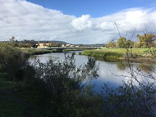
The San Lorenzo River is a 29.3-mile-long (47.2 km) river in the U.S. state of California. The name San Lorenzo derives from the Spanish language for "Saint Lawrence" due to its reported sighting on that saint's feast day by Spanish explorers. Its headwaters originate in Castle Rock State Park in the Santa Cruz Mountains and flow south by southeast through the San Lorenzo Valley before passing through Santa Cruz and emptying into Monterey Bay and the Pacific Ocean.

The Trinity River is a major river in northwestern California in the United States and is the principal tributary of the Klamath River. The Trinity flows for 165 miles (266 km) through the Klamath Mountains and Coast Ranges, with a watershed area of nearly 3,000 square miles (7,800 km2) in Trinity and Humboldt Counties. Designated a National Wild and Scenic River, along most of its course the Trinity flows swiftly through tight canyons and mountain meadows.

The Necanicum River is a river on the Pacific coast of northwest Oregon in the United States, approximately 21 miles (34 km) long. It drains a timber-producing area of the Northern Oregon Coast Range northwest of Portland. It forms the first estuary south of the mouth of the Columbia River along the Oregon Coast, reaching the Pacific Ocean at Seaside in Clatsop County.

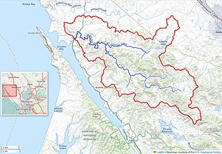
Coyote Creek is a river that flows through the Santa Clara Valley in Northern California. Its source is on Mount Sizer, in the mountains east of Morgan Hill. It eventually flows into Anderson Lake in Morgan Hill and then northwards through Coyote Valley to San Jose, where it empties into San Francisco Bay.

The Surface Mining Control and Reclamation Act of 1977 (SMCRA) is the primary federal law that regulates the environmental effects of coal mining in the United States.

The Office of Surface Mining Reclamation and Enforcement (OSMRE) is a branch of the United States Department of the Interior. It is the federal agency entrusted with the implementation and enforcement of the Surface Mining Control and Reclamation Act of 1977 (SMCRA), which attached a per-ton fee to all extracted coal in order to fund an interest-accruing trust to be used for reclamation of abandoned mine lands, as well as established a set environmental standards that mines must follow while operating, and achieve when reclaiming mined land, in order to minimize environmental impact. OSMRE has fewer than 500 employees, who work in either the national office in Washington, DC, or of the many regional and field offices.

Lagunitas Creek is a 24-mile-long (39 km) northward-flowing stream in Marin County, California. It is critically important to the largest spawning runs of endangered coho salmon in the Central California Coast Coho salmon Evolutionary Significant Unit.

The Mattole River is a river on the north coast of California, that flows northerly, then westerly into the Pacific Ocean. The vast majority of its 62 miles (100 km) course is through southern Humboldt County, though a short section of the river flows through northern Mendocino County. Communities, from north to south, closely associated with the Mattole River include: Petrolia, Honeydew, Ettersburg, Thorn Junction, and Whitethorn. The river enters the ocean at the Mattole Estuary about 4 miles (6.4 km) west-southwest of Petrolia and 10 miles (16 km) south of Cape Mendocino.

Arroyo Corte Madera del Presidio is a 4.1-mile-long (6.6 km) year-round stream in southern Marin County, California, United States. This watercourse is also known as Corte Madera Creek, although the actual stream of that name flows into San Francisco Bay further north at Point San Quentin. This watercourse has a catchment basin of about 8 square miles (21 km2) and drains the south-eastern slopes of Mount Tamalpais and much of the area in and around the town of Mill Valley; this stream discharges to Richardson Bay.

Issaquah Creek is a small stream flowing through the city of Issaquah and nearby communities, in the U.S. state of Washington. Its headwaters are on the slopes of Cougar, Squak, Tiger, and Taylor mountains in the Issaquah Alps. Tributaries of Issaquah Creek include Holder Creek, Carey Creek, Fifteen-mile Creek, McDonald Creek, East Fork Issaquah Creek, and North Fork Issaquah Creek. The creek empties into the south end of Lake Sammamish. The lake's outlet is the Sammamish River, which in turn empties into Lake Washington and ultimately Puget Sound.

San Gregorio Creek is a river in San Mateo County, California. Its tributaries originate on the western ridges of the Santa Cruz Mountains whence it courses southwest through steep forested canyons. The San Gregorio Creek mainstem begins at the confluence of Alpine and La Honda Creeks, whence it flows 12 miles (19 km) through rolling grasslands and pasturelands until it meets the Pacific Ocean at San Gregorio State Beach. It traverses the small unincorporated communities of La Honda, San Gregorio, Redwood Terrace and Sky Londa.
Pescadero Creek is a major stream in Santa Cruz and San Mateo counties in California, United States. At 26.6 miles (42.8 km), it is the longest stream in San Mateo County and flows all year from springs in the Santa Cruz Mountains. Its source is at 1,880 feet (570 m) above sea level on the western edge of Castle Rock State Park, with additional headwaters in Portola Redwoods State Park, and its course traverses Pescadero Creek County Park and San Mateo County Memorial Park before entering Pescadero Marsh Natural Preserve at Pescadero State Beach and thence to the Pacific Ocean 14.4 miles (23 km) south of Half Moon Bay.
Walker Creek is a northwest-flowing stream in western Marin County, California, United States. It originates at the confluence of Salmon Creek and Arroyo Sausal, and empties into Tomales Bay south of Dillon Beach, California.

Boeing Creek is a stream in the U.S. state of Washington, located in the city of Shoreline, just north of Seattle. It is about 1.6 miles (2.6 km) long and empties into Puget Sound. The creek is heavily modified along its course, and in many places has been diverted into culverts. The watershed of Boeing Creek is about 11.2 square miles (29 km2) in size, with two main tributaries aside from the mainstem. The creek takes its name from William Boeing, who built a mansion along the creek in 1913. Despite the river modifications and stormwater pollution, the creek supports a variety of riparian habitats, native animals and fishes.
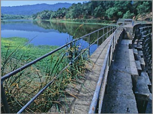
Searsville Dam is a masonry dam in San Mateo County, California, that was completed in 1892, one year after the founding of Stanford University, and impounds Corte Madera Creek to form a reservoir known as Searsville Reservoir or Searsville Lake. Searsville Dam is located in the Jasper Ridge Biological Preserve and is owned and operated by Stanford University. Neighboring cities include Woodside and Portola Valley, California.

Stony Creek is a 73.5-mile (118.3 km)-long tributary of the Sacramento River in Northern California. It drains a watershed of more than 700 square miles (1,800 km2) on the west side of the Sacramento Valley in Glenn, Colusa, Lake and Tehama Counties.
The Audenried Tunnel, also known as the Audenried Mine Tunnel, is a drainage tunnel located in East Union Township, Schuylkill County, Pennsylvania, in the United States. It is approximately three miles long and drains the western portion of a coal basin near Kelayres.
Solomon Creek is a tributary of the Susquehanna River in Luzerne County, Pennsylvania, in the United States. It is approximately 8.8 miles (14.2 km) long and flows through Fairview Township, Hanover Township, and Wilkes-Barre. The creek is affected by acid mine drainage and has significant loads of iron, aluminum, and manganese. The creek's named tributaries are Spring Run, Sugar Notch Run, and Pine Creek. The Solomon Creek watershed is located in the Anthracite Valley section of the ridge-and-valley geographical province. Major rock formations in the watershed include the Mauch Chunk Formation, the Spechty Kopf Formation, and the Catskill Formation.

