Related Research Articles
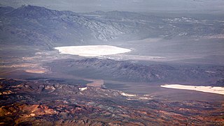
Groom Lake is a dry lake, also described as a salt flat, in Nevada. It is used for runways of the Nellis Bombing Range Test Site airport (KXTA). Part of the Area 51 USAF installation, it lies at an elevation of 4,409 ft (1,344 m) and is approximately 3.7 miles (6.0 km) from north to south and 3 miles (4.8 km) from east to west at its widest point, and is approximately 11.3 miles in circumference. Located within the namesake Groom Lake Valley portion of the Tonopah Basin, the lake is 25 mi (40 km) south of Rachel, Nevada.
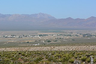
Sandy Valley is an unincorporated community in the Mesquite Valley in west–central Clark County, Nevada, United States. Sandy Valley has a variant name of Sandy, Nevada. The population was 2,051 at the 2010 census. Sandy Valley is bordered on the East by the southern extension of the Spring Mountains and on the west by the California state line. Sandy Valley began in the 19th century as the five mining communities of Kingston, Sandy, Ripley, Mesquite and Platina. It is approximately forty-five miles from Las Vegas.

Eureka is an unincorporated town and census-designated places in and the county seat of Eureka County, Nevada, United States. With a population of 480 as of the 2018 American Community Survey 5-Year Estimates, it is by far the largest community in Eureka County. Attractions include the Eureka Opera House, Raine’s Market and Wildlife Museum, the Jackson House Hotel, and the Eureka Sentinel Museum.
The White River is a small and discontinuous 138-mile-long (222 km) river located in southeastern Nevada notable for several endemic species of fish.

The Pahranagat Valley is a Tonopah Basin landform in Lincoln County, Nevada.
Primm Valley Resort & Casino is a hotel and casino located in Primm, Nevada. It is one of the Primm Valley Resorts, owned and operated by Affinity Gaming. It is named after the Primm family, benefactors of the hotel and casino properties by Ernest and Gary Primm.
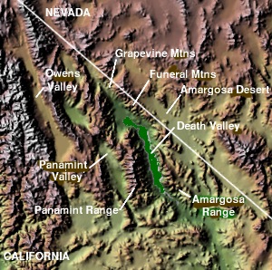
The Panamint Valley is a long basin located east of the Argus and Slate ranges, and west of the Panamint Range in the northeastern reach of the Mojave Desert, in eastern California, United States.

The Pancake Range is located in east-central Nevada in the United States. The range extends as an irregular sinuous line for approximately 90 miles (140 km) with a roughly north-south trend in Nye and White Pine counties. The range reaches an elevation of 9,240 feet (2,820 m) at Portuguese Mountain. Neighboring ranges include the White Pine, Grant and Quinn Canyon ranges across Railroad Valley on the east-southeast; and Park and Hot Creek ranges across Big Sandy Springs and Hot Creek valleys on the west-northwest. The south end of Newark Valley lies at the extreme north end of the range. The Lunar Crater Volcanic Field lies at the southwestern end of the chain with the Reveille Range to the south.

Lanfair Valley is located in the Mojave Desert in southeastern California near the Nevada state line. It is bounded on the north by the New York Mountains and Castle Mountains, on the east by the Piute Range, and on the south by the Woods Mountains and Vontrigger Hills. Joshua Trees can be found in most of the valley. Elevation is 4,045 feet.

Nevada's 3rd congressional district is a congressional district occupying the area south of Las Vegas, including Henderson, Boulder City and much of unincorporated Clark County. The district was initially created after the 2000 census.

Tollhouse is an unincorporated community in Fresno County, California. It lies at an elevation of 1,919 feet (585 m). Tollhouse is located in the Sierra Nevada, 7 miles (11 km) southwest of Shaver Lake and 18 miles southwest of Huntington Lake. It is home to 2,089 people.
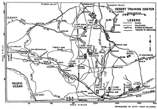
The Desert Training Center (DTC), also known as California–Arizona Maneuver Area (CAMA), was a World War II training facility established in the Mojave Desert and Sonoran Desert, largely in Southern California and Western Arizona in 1942.
Rum Creek is a stream in the U.S. state of West Virginia.
Andys Creek is a stream in eastern Wayne County, Missouri. It is a tributary of Bear Creek.
Clear Creek is a stream in Cedar, Barton, Vernon and St. Clair counties of southwest Missouri. It is a tributary to the Osage River.
Coin is an unincorporated community in Elko County, in the U.S. state of Nevada.
Moleen is an extinct town in Elko County, in the U.S. state of Nevada. The GNIS classifies it as a populated place.
Secret Valley is a valley in the U.S. state of Nevada.
Mount Irish is a summit in the Mount Irish Range, in the U.S. state of Nevada. The elevation is 8,625 feet (2,629 m).
Silver Canyon is a valley in the U.S. state of Nevada.
References
- ↑ U.S. Geological Survey Geographic Names Information System: Coal Valley (Nevada)
- ↑ Federal Writers' Project (1941). Origin of Place Names: Nevada (PDF). W.P.A. p. 43.
Coordinates: 37°56′12″N115°14′39″W / 37.93667°N 115.24417°W
| This Lincoln County, Nevada state location article is a stub. You can help Wikipedia by expanding it. |
| This Nye County, Nevada state location article is a stub. You can help Wikipedia by expanding it. |