
Puget Sound is a sound of the Pacific Northwest, an inlet of the Pacific Ocean, and part of the Salish Sea. It is located along the northwestern coast of the U.S. state of Washington. It is a complex estuarine system of interconnected marine waterways and basins, with one major and two minor connections to the open Pacific Ocean via the Strait of Juan de Fuca—Admiralty Inlet being the major connection and Deception Pass and Swinomish Channel being the minor.

The San Juan Islands is an archipelago in the Pacific Northwest of the United States between the U.S. state of Washington and Vancouver Island, British Columbia, Canada. The San Juan Islands are part of Washington state, and form the core of San Juan County.

The Strait of Juan de Fuca is a body of water about 96 miles long that is the Salish Sea's main outlet to the Pacific Ocean. The international boundary between Canada and the United States runs down the centre of the Strait.

The Taiwan Strait is a 180-kilometer -wide strait separating the island of Taiwan and continental Asia. The strait is part of the South China Sea and connects to the East China Sea to the north. The narrowest part is 130 km wide.
The Sulu Sea is a body of water in the southwestern area of the Philippines, separated from the South China Sea in the northwest by Palawan and from the Celebes Sea in the southeast by the Sulu Archipelago. Borneo is found to the southwest and Visayas to the northeast.

The Celebes Sea or Sulawesi Sea of the western Pacific Ocean is bordered on the north by the Sulu Archipelago and Sulu Sea and Mindanao Island of the Philippines, on the east by the Sangihe Islands chain, on the south by Sulawesi's Minahasa Peninsula, and on the west by northern Kalimantan in Indonesia. It extends 420 miles (675 km) north-south by 520 mi (840 km) east-west and has a total surface area of 110,000 square miles (280,000 km2), to a maximum depth of 20,300 feet (6,200 m). South of the Cape Mangkalihat, the sea opens southwest through the Makassar Strait into the Java Sea.

The Strait of Georgia or the Georgia Strait is an arm of the Salish Sea between Vancouver Island and the extreme southwestern mainland coast of British Columbia, Canada, and the extreme northwestern mainland coast of Washington, United States. It is approximately 240 kilometres (150 mi) long and varies in width from 20 to 58 kilometres. Along with the Strait of Juan de Fuca and Puget Sound, it is a constituent part of the Salish Sea.

Makassar Strait is a strait between the islands of Borneo and Sulawesi in Indonesia. To the north it joins the Celebes Sea, while to the south it meets the Java Sea. To the northeast, it forms the Sangkulirang Bay south of the Mangkalihat Peninsula. The strait is an important regional shipping route in Southeast Asia.
The Inside Passage is a coastal route for ships and boats along a network of passages which weave through the islands on the Pacific Northwest coast of the North American Fjordland. The route extends from southeastern Alaska in the United States, through western British Columbia in Canada, to northwestern Washington state in the United States. Ships using the route can avoid some of the bad weather in the open ocean and may visit some of the many isolated communities along the route. The Inside Passage is heavily travelled by cruise ships, freighters, tugs with tows, fishing craft, pleasure craft, and ships of the Alaska Marine Highway, BC Ferries, and Washington State Ferries systems. Coast Guard vessels of both Canada and the United States patrol and transit in the Passage.

Queen Charlotte Sound is a sound of the Pacific Ocean in British Columbia, Canada, between Vancouver Island in the south and Haida Gwaii in the north. It merges with Hecate Strait in the north and Queen Charlotte Strait in the south.

Queen Charlotte Strait is a strait between Vancouver Island and the mainland of British Columbia, Canada. It connects Queen Charlotte Sound with Johnstone Strait and Discovery Passage and via them to the Strait of Georgia and Puget Sound. It forms part of the Inside Passage from Washington to Alaska. The term Queen Charlotte Strait is also used to refer to the general region and its many communities, notably of the Kwakwakaʼwakw peoples. Despite its name, Queen Charlotte Strait does not lie between Haida Gwaii and the mainland; that body of water is named Hecate Strait.

The British Columbia Coast, popularly referred to as the BC Coast or simply the Coast, is a geographic region of the Canadian province of British Columbia. As the entire western continental coastline of Canada along the Pacific Ocean is in the province, it is synonymous with being the West Coast of Canada.
Laich-kwil-tach, is the Anglicization of the Kwak'wala autonomy by the "Southern Kwakiutl" people of Quadra Island and Campbell River in British Columbia, Canada. There are today two main groups : the Wei Wai Kai and Wei Wai Kum just across on the Vancouver Island "mainland" in the town of Campbell River. In addition to these two main groups there are the Kwiakah originally from Phillips Arm and Frederick Arm and the Discovery Islands, the Tlaaluis (Laa'luls) between Bute and Loughborough Inlets—after a great war between the Kwakiutl and the Salish peoples they were so reduced in numbers that they joined the Kwiakah—and the Walitsima / Walitsum Band of Salmon River.
The Salish Sea is a marginal sea of the Pacific Ocean located in the Canadian province of British Columbia and the U.S. state of Washington. It includes the Strait of Georgia, the Strait of Juan de Fuca, Puget Sound, and an intricate network of connecting channels and adjoining waterways.

Milbanke Sound is a sound on the coast of the Canadian province of British Columbia.
Wright Sound is a waterway on the North Coast of British Columbia, Canada. Wright Sound is 135 kilometers (84 mi) south of Prince Rupert and lies at the southern opening of Grenville Channel and between Gil, Gribbell and Pitt Islands. The small town of Hartley Bay sits on its northern shore and is home to the Gitga'ata, a Tsimshian group. On the north side of Wright Sound develops the Douglas Channel.

The Inner Seas off the West Coast of Scotland is a marine area designated by the International Hydrographic Organization (IHO). It consists of a number of waterbodies between the Scottish mainland, the Outer Hebrides islands, and the coast of Ireland.

The borders of the oceans are the limits of Earth's oceanic waters. The definition and number of oceans can vary depending on the adopted criteria. The principal divisions of the five oceans are the Pacific Ocean, Atlantic Ocean, Indian Ocean, Southern (Antarctic) Ocean, and Arctic Ocean. Smaller regions of the oceans are called seas, gulfs, bays, straits, and other terms. Geologically, an ocean is an area of oceanic crust covered by water.
The Nisqually Reach is a portion of Puget Sound south of the Tacoma Narrows, near the Nisqually River delta. It is classified as a bay by the United States government. It was originally defined as "the portion of the Sound lying between Anderson Island and the mainland".
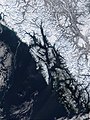 Image showing the Alexander Archipelago of south-east Alaska - the waters of the archipelago are the northern portion of the Coastal Waters.
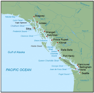
 Map showing Dixon Entrance, Hecate Strait, Queen Charlotte Strait and Queen Charlotte Sound - the central portion of the Coastal Waters.
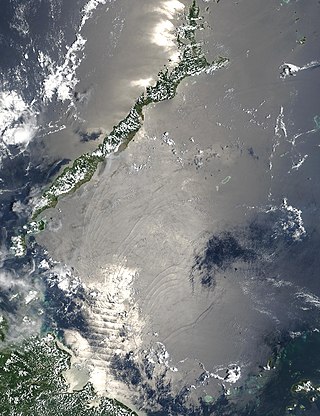
 Image showing the Salish Sea, which includes the Strait of Juan de Fuca, Puget Sound and the Strait of Georgia - the southern portion of the Coastal Waters.


