
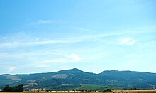
The Coburg Hills are a range of foothills of the western Cascade Range of Lane and Linn counties in the U.S. state of Oregon. [1] They are located northeast of Eugene and east of Coburg, between the Mohawk Valley and Willamette Valley.
The Coburg Hills are a range of foothills of the western Cascade Range of Lane and Linn counties in the U.S. state of Oregon. [1] They are located northeast of Eugene and east of Coburg, between the Mohawk Valley and Willamette Valley.
The Coburg Hills rise to an elevation of approximately 2,253 feet at Coburg Ridge. [2]
One of the most notable features of the Coburg Hills is a gap or saddle at its north end called the Hayworth Saddle. This previously unnamed feature was officially named in 2008, after Register-Guard columnist Bob Welch asked readers for suggestions. Eventually, they voted for "Hayworth Ridge", after a local family who has been farming near there since 1875. The name was changed to "Hayworth Saddle" by the Oregon Geographic Names Board, which in turn recommended it to the U.S. Board on Geographic Names. The board adopted the name in September 2008. [3] [4]
Individual summits in the range include Spores Point, Buck Mountain, Mount Tom, Round Mountain, and Bald Mountain.

The Pudding River is a 62-mile (100 km) tributary of the Molalla River in the U.S. state of Oregon. Its drainage basin covers 528 square miles (1,368 km2). Among its tributaries are Silver Creek, Butte Creek, Abiqua Creek, and the Little Pudding River.
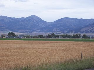
The Bridger Range, also known as the Bridger Mountains, is a subrange of the Rocky Mountains in southwestern Montana in the United States. The range runs mostly in a north–south direction between Bozeman and Maudlow. It is separated from the Gallatin Range to the south by Bozeman Pass; from the Horseshoe Hills to the west by Dry Creek; from the Crazy Mountains to the east by the Shields River valley; and from the Big Belt Mountains to the north by Sixteen Mile Creek. The highest point in the Bridger Range is Sacagawea Peak, which is visible to the northeast from Bozeman.
The Ohio Range is a mountain range in the Transantarctic Mountains of Antarctica. It is about 48 km (30 mi) long and 16 km (10 mi) wide, extending WSW-ENE from Eldridge Peak to Mirsky Ledge. The range forms the northeast end of the Horlick Mountains and consists primarily of a large snow-topped plateau with steep northern cliffs and several flat-topped ridges and mountains. The highest point is the summit of Mount Schopf.

Mount Baker Wilderness is a 119,989-acre (48,558 ha) wilderness area within the Mount Baker-Snoqualmie National Forest in the western Cascade Range of northern Washington state. Its eastern border is shared with the boundary of the Stephen Mather Wilderness and North Cascades National Park for a distance of 40 miles. The wilderness extends from State Route 20 north to the Canada–US border. On the west, it is bounded by the foothills of the Puget Sound lowlands.

Mill Creek Falls, is a waterfall located in the Rogue River Canyon within the Prospect State Scenic Viewpoint in Jackson County, in the U.S. state of Oregon. The waterfall is located at the south end of Mill Creek as it plunges into the Rogue River over a carved cliff surrounded by walls of petrified volcanic ash consequence of Mount Mazama eruption.
Bald Mountain is a name given to over fifty summits in California.

Low Pass is an unincorporated community in Lane County, Oregon, United States, on the Long Tom River, 5 miles (8 km) east of Blachly and 11 miles (18 km) west of Cheshire.
High Pass is a mountain pass in the foothills of the Coast Range mountains in Lane County, Oregon, United States. High Pass Road connects the unincorporated community of Horton, on the west side of the pass, with Cheshire, Monroe, Junction City, and the other low-lying farm towns to the east. Oregon Route 36 provides an alternate route through the foothills over the nearby Low Pass.

Rickreall Creek is a stream in Polk County, Oregon, United States rising on Laurel Mountain in the Central Oregon Coast Range and draining into the Willamette River west of Salem at Eola. The creek passes through the city of Dallas and the unincorporated community of Rickreall. The origin of the name is under some dispute, but one theory says that "Rickreall" is a corruption of "La Creole", La Creole River being another name for the stream.
Necanicum is an unincorporated community in Clatsop County, Oregon, United States. It is located approximately 13 miles southeast of Seaside on U.S. Route 26 in the Northern Oregon Coast Range, next to the Necanicum River. Necanicum Junction is about a mile east of the site of the former post office, at the intersection of U.S. 26 and Oregon Route 53. It is served by the Seaside post office.

Horse Rock Ridge is a ridgetop located on the western edge of the Cascade Range near Crawfordsville, Oregon. The site is recognized for its considerable diversity of plant species that includes both Willamette Valley plants as well as plants more often found in the mountain zone of the Cascade Range. There are also several plant species more often found east of the Cascade Range.
Temescal Mountains, also known as the Sierra Temescal, are one of the northernmost mountain ranges of the Peninsular Ranges in western Riverside County, in Southern California in the United States. They extend for approximately 25 mi (40 km) southeast of the Santa Ana River east of the Elsinore Fault Zone to the Temecula Basin and form the western edge of the Perris Block.
Paris is an unincorporated community in Lane County, in the U.S. state of Oregon. It is a rural locale in the Central Oregon Coast Range north of the Siuslaw River and south of the Alsea River along one of its tributaries, Five Rivers. Paris is located at 44°15′09″N123°46′14″W.
Alpha is an unincorporated community in Lane County, in the U.S. state of Oregon. Alpha is located at 44°09′51″N123°42′02″W.
Myrtle Creek is a short tributary of the South Umpqua River in Douglas County in the U.S. state of Oregon. Its main stem, formed by the confluence of two forks just south of the city of Myrtle Creek, is only about 1 mile (1.6 km) long. Its only named tributaries are the two forks, North Myrtle Creek and South Myrtle Creek, each of which is much longer than the main stem.
44°07′30″N123°00′05″W / 44.125125°N 123.001474°W
| | This Lane County, Oregon state location article is a stub. You can help Wikipedia by expanding it. |
| | This Linn County, Oregon state location article is a stub. You can help Wikipedia by expanding it. |