It covers an area of 55km2 (21sqmi) (11km (7mi) long by 6km (4mi)), with a population of about 8,200 (1999 census). The highest elevation of the island is 60 metres (197ft)above sea level. The climate is tropical, with an average temperature of approximately 27 to 38°C (81 to 100°F).[6]
Other towns on Coche besides San Pedro de Coche are El Bichar, Guinima, El Amparo, El Guamache, and La Uva. The economy depends mainly on tourism.
The island was discovered in 1498 by Christopher Columbus, populated by the Waika Rio indigenous people.[7] First efforts to settle Coche was made in the early 16th century. There was previous population of refugees originating from the city of Nueva Cádiz which was destroyed by a tropical storm on Cubagua Island. All settlers, mostly the pearl daughters, abandoned Isla Coche in 1574.
The next successful settlement took place in the 19th century, and from this date Coche is still inhabited.
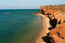
El Amor Beach, Coche Island
The island is contained as the municipality of Villalba, with both having San Pedro de Coche as their capital.
Coche Island is uniquely positioned for quality selective tourism (not massive). To the west of the island the conditions for windsurfing and kiteboarding (strong winds over 50km/h with a sea without waves) and trucks candle can be cited among the best in the world.[8] It can see the effect of strong winds and continued in the sparse vegetation of the island, as seen in the image of San Pedro de Coche. On the road can be practiced the cycling, naturally with sunscreen to prevent sunburn, given the absence of clouds over the year. The temperature, though high, is pleasant in the fresh sea air, considering that breeze rages precisely in the hottest hours of the afternoon.
On the island, there are good quality hotels that offer tourists all the necessary facilities for a pleasant stay. It also offers rides and tours both aquatic and terrestrial. Tourist purposes, Coche Island maintains close communication with Margarita Island and the Venezuelan mainland Sucre State.[9]
The story of the Polish writer Arkady Fiedler's novel "Robinson's Island" (Wyspa Robinsona, 1954) took place in Coche Island. The protagonist Jan (John) Bober, a half-Polish half-English Virginia pioneer, fled from government pursuit by a pirate ship. However it ran into heavy water and wrecked near the island. Jan and his two Arawak companions Arnak and Wagura (former slaves from the ship), the only survivors of the shipwreck, lived in 1725–1726 in the island. Later they received in the island a group of fled slaves from Margarita Island and with combined forces defeated Spanish slaver pursuers and seized their ship. Fearing Spanish revenge, Jan and his followers left the island on the captured ship. Their adventures continued in the two next Arkady Fiedler's novels "Orinoco" (Orinoko, 1957) and "The White Jaguar" (Biały Jaguar, 1980).
This page is based on this Wikipedia article Text is available under the CC BY-SA 4.0 license; additional terms may apply. Images, videos and audio are available under their respective licenses.