Related Research Articles
Rivers Inlet is a fjord in the Central Coast region of the Canadian province of British Columbia, its entrance off Fitz Hugh Sound, about 125 km (78 mi) southwest of the community of Bella Coola and about 65 km (40 mi) north of the northern tip of Vancouver Island and the western entrance of the Queen Charlotte Strait.

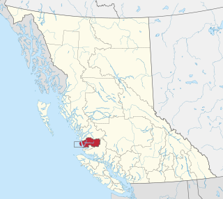
Marble Canyon is in the south-central Interior of British Columbia, a few kilometres east of the Fraser River and the community of Pavilion, midway between the towns of Lillooet and Cache Creek. The canyon stems from a collapsed karst formation.
Bulkley Junction Provincial Park is a provincial park in British Columbia, Canada, located on the west side of the Skeena River opposite Hazelton. It was established in 1997 and expanded in 2004 from 133 ha. to its current size of 169 ha.
The Upper Similkameen Indian Band or Upper Smelqmix, is a First Nations band government in the Canadian province of British Columbia, whose head offices are located in town of Hedley in the Similkameen Country. They are a member of the Okanagan Nation Alliance.

The Gwa'Sala-Nakwaxda'xw Nations are a union of two Kwakwaka'wakw peoples in a band government based on northern Vancouver Island in British Columbia, Canada, whose main reserve community is near the town of Port Hardy in the Queen Charlotte Strait region of the Central Coast region of British Columbia, Canada. The band government is a member of the Kwakiutl District Council and, for treaty negotiation purposes, the Winalagalis Treaty Group which includes three other members of the Kwakiutl District Council.
Ḵwiḵwa̱sut'inux̱w Ha̱xwa'mis, formerly the Kwicksutaineuk-ah-kwa-mish First Nation is a First Nations band government based on northern Vancouver Island in British Columbia, Canada, in the Queen Charlotte Strait region. It is a member of the Musgamagw Tsawataineuk Tribal Council, along with the ‘Namgis First Nation and the Tsawataineuk First Nation. The Kwikwasut'inuxw and Haxwa'mis are two of the many subgroups of the peoples known as Kwakwaka'wakw, which has two meanings: "smoke of the world" or "beach at the north side of the river."
The Skeetchestn Indian Band is a member of the Secwepemc (Shuswap) Nation, located in the Central Interior region of the Canadian province of British Columbia. Its main Indian reserve is located at Savona, British Columbia. The reserve was set up in the 1860s when the government of the then-Colony of British Columbia established an Indian reserve system. The Skeetchestn is a member government of the Shuswap Nation Tribal Council.
The Ashcroft First Nation is a First Nations government Thompson Canyon area of the Central Interior of the Canadian province of British Columbia. Its Indian Reserves are located near the town of Ashcroft, British Columbia, it is a member of the Nlaka'pamux Nation Tribal Council.
The Lytton First Nation, a First Nations band government, has its headquarters at Lytton in the Fraser Canyon region of the Canadian province of British Columbia. While it is the largest of all Nlaka'pamux bands, unlike all other governments of the Nlaka'pamux (Thompson) people, it is not a member of any of the three Nlaka'pamux tribal councils, which are the Nicola Tribal Association, the Fraser Canyon Indian Administration and the Nlaka'pamux Nation Tribal Council.
The Wuikinuxv Nation, also known as the Oweekeno Nation, is a First Nations band government whose traditional territory is the shores of Rivers Inlet and Owikeno Lake in the Central Coast region of the Canadian province of British Columbia, in the area south of Bella Bella and north of Queen Charlotte Strait. The Wuikinuxv people a.k.a. the Oweekeno people reside in the area of Rivers Inlet and Owikeno Lake, primarily at a village on the Wannock River. Substantial numbers of Wuikinuxv also reside away from the traditional territory in Port Hardy on Vancouver Island and in larger BC communities such as Campbell River, Vancouver and Victoria. Approximately 80 people reside at the village while overall membership was 283 in 2006, 194 of whom lived off-reserve.
The WuikinuxvIPA:[ʔuwik'inuxʷ],, also rendered Oweekano (Pre-1976); Oowekeeno (1976-2003) are an Indigenous First Nations people of the Central Coast region of the Canadian province of British Columbia, located around Rivers Inlet and Owikeno Lake, to the north of Queen Charlotte Strait. The Wuikinuxv people and their neighbours the Heiltsuk and Haisla peoples were in the past sometimes known incorrectly as the "Northern Kwakiutl".
The Tenaiko Range is a small subrange of the Kitimat Ranges in British Columbia, Canada. It is surrounded by the Gamsby River and Tenaiko Creek. It reaches a height of 1,042 meters above sea level.
Wakeman Sound is a sound on the South Coast of British Columbia, Canada, located in the area north of the Broughton Archipelago, which lies on the north side of Queen Charlotte Strait, on the northeast side of Broughton Island. It is a sidewater opening of and opening north off Kingcome Inlet.
Yale First Nation is a First Nations government located at Yale, British Columbia. Yale has 16 distinct reserves stretching from near Sawmill Creek to American Creek, with the most southern reserve situated at Ruby Creek in the District of Kent.
The Taku River Tlingit First Nation are the band government of the Inland Tlingit in far northern British Columbia, Canada and also in Yukon. They comprise two ḵwaan (tribes) of the Tlingit people, who are otherwise coastal, the Áa Tlein Ḵwáan of the Atlin Lake area and the Deisleen Ḵwáan of Teslin Lake, whose main focus is the Teslin Tlingit Council in Teslin, Yukon. Their band offices are in Atlin, British Columbia.
The Tlowitsis Nation, formerly the Klowitsis Tribe, the Turnour Island Band and the Tlowitsis-Mumtagila First Nation, is the Indian Act band government of the Ławit'sis (Tlowitsis) tribe of the Kwakwaka'wakw peoples, located in the Queen Charlotte Strait-Johnstone Strait area in the Discovery Islands between Vancouver Island and the British Columbia mainland in Canada. Ławit'sis territory covers parts of northern Vancouver Island, Johnstone Strait, and adjoining inlets of the mainland. Kalugwis, on Turnour Island, was their principal community in times past, but the band's offices are in the city of Campbell River to the southeast. Hanatsa IR No. 6 on Port Neville is the most populated of the band's Indian reserves.
Kilbella Bay is a bay on the Central Coast of British Columbia, Canada, off the north side of Rivers Inlet to the northeast of McAllister Point. A steamer landing formerly operated by the Northland Navigation Company was located on the east side of the bay.
Katit Indian Reserve No. 1 is the main Indian reserve of the Wuikinuxv people, and is one of the three reserves governed by the Wuikinuxv Nation band government. It is located in British Columbia, Canada, on the entrance to Owikeno Lake on the north side of the Wannock River near to, but separate from, the non-native community and sport fishing resort of Rivers Inlet. Similarly named Katit Island is in the Wannock River at 51°40′41″N127°11′48″W, while Kahtit Creek is downstream, near the mouth of the Wannock River at 51°40′47″N127°15′00″W near the Wuikinuxv village known as Oweekeno.

The Nekite River is a river in the Central Coast region of British Columbia, Canada, flowing south to the head of Smith Inlet. Nekite Indian Reserve No. 2 is located at the mouth of the river and is one of the many reserves of the Gwa'sala-'Nakwaxda'xw Nations band government located in the area of Smith Sound, of which Smith Inlet is the uppermost part.
Long Lake is a lake south of the head of Smith Inlet in the Central Coast region of British Columbia, Canada. It flows west into the Smith Inlet and its main tributary is Smokehouse Creek at its north-east end.
References
51°31′00″N127°41′00″W / 51.51667°N 127.68333°W
| | This article about a location on the Central Coast of British Columbia, Canada is a stub. You can help Wikipedia by expanding it. |