
Antigua and Barbuda is a sovereign island country in the Caribbean. It lies at the conjuncture of the Caribbean Sea and the Atlantic Ocean in the Leeward Islands part of the Lesser Antilles.
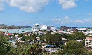
St. John's is the capital and largest city of Antigua and Barbuda, part of the West Indies in the Caribbean Sea. With a population of 22,219, St. John's is the commercial centre of the nation and the chief port of the island of Antigua.
The history of Antigua and Barbuda covers the period from the arrival of the Archaic peoples thousands of years ago to the present day. Prior to European colonization, the lands encompassing present-day Antigua and Barbuda were inhabited by three successive Amerindian societies. The island was claimed by England, who settled the islands in 1632. Under English/British control, the islands witnessed an influx of both Britons and African slaves migrate to the island. In 1981, the islands were granted independence as the modern state of Antigua and Barbuda.
Barbuda is an island located in the eastern Caribbean forming part of the twin-island state of Antigua and Barbuda as an autonomous entity. Barbuda is located approximately 30 miles (48 km) north of Antigua. The sole settlements on the island are Codrington and its surrounding localities. Barbuda is a flat island with the western portion being dominated by Codrington Lagoon, and the eastern portion being dominated by the low-lying Barbuda Highlands, with salty ponds and scrubland spread throughout the island. The climate is classified as tropical marine.

Port Stephens, an open youthful tide-dominated drowned-valley estuary, is a large natural harbour of approximately 134 square kilometres (52 sq mi) located in the Hunter and Mid North Coast regions of New South Wales, Australia.

Saint George, officially the Parish of Saint George, is a parish of Antigua and Barbuda on the island of Antigua. Saint George borders Saint Peter to the southeast, and Saint John to the west and south. Saint George is mostly farmland and savanna in the south, dense forest in the Blackman's Peninsula area, marshland in the Fitches Creek area, and dense forest in the northwest. It is the smallest parish in Antigua and Barbuda, and the parish capital is Fitches Creek. The largest city in the parish is Piggotts. Saint George is the newest parish, splitting from the parish of Saint Peter in 1725. It had a population of 7,976 in 2011.

Antigua, also known as Waladli or Wadadli by the native population, is an island in the Lesser Antilles. It is one of the Leeward Islands in the Caribbean region and the most populous island of the country of Antigua and Barbuda. Antigua and Barbuda became an independent state within the Commonwealth of Nations on 1 November 1981.

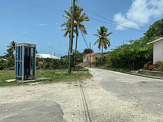
Codrington is the only village on the island of Barbuda, which is part of the country of Antigua and Barbuda. Codrington coincides with the Codrington major division, one of the two major divisions on Barbuda. Situated on the Codrington Lagoon, Codrington is the country's northernmost settlement. The population of Codrington was 796 in 2011.
Crump Island is an island off the northeast coast of Antigua. It is located to the southeast of Guana Island in Belfast Bay, close to the town of Seaton's.

Green Island is a small island lying off the eastern coast of Antigua. It is a private island that has been owned by the Mill Reef Club since 1947. It lies close to the mouth of Nonsuch Bay.
Bethesda is a village in Saint Paul Parish on the island of Antigua, in Antigua and Barbuda.
Potworks Dam is in central Antigua located close to Bethesda. One of the most significant water treatment facilities on the island is located on the southern shore at the Delapps Water Treatment Plant.
The following outline is provided as an overview of and introduction to Antigua and Barbuda:

Antigua and Barbuda lie in the eastern arc of the Leeward Islands of the Lesser Antilles, separating the Atlantic Ocean from the Caribbean Sea. Antigua is 650 km (400 mi) southeast of Puerto Rico; Barbuda lies 48 km (30 mi) due north of Antigua, and the uninhabited island of Redonda is 56 km (35 mi) southwest of Antigua.

San Andrés is a coral island in the Caribbean Sea. Politically part of Colombia, and historically tied to the United Kingdom, San Andrés and the nearby islands of Providencia and Santa Catalina form the department of San Andrés, Providencia and Santa Catalina. San Andrés, in the southern group of islands, is the largest of Colombia. The official languages of the department are Spanish, English, and San Andrés–Providencia Creole.

Nepean Bay is a bay located on the north-east coast of Kangaroo Island in the Australian state of South Australia about 130 kilometres south-south-west of Adelaide. It was named by the British navigator, Matthew Flinders, after Sir Evan Nepean on 21 March 1802.

Five Islands Village is a village located on the northwest coast of Antigua, within Saint John Parish in Antigua and Barbuda.

Squatting in the island country of Antigua and Barbuda in the West Indies is the occupation of unused land or derelict buildings without the permission of the owner. Historically, native Barbudans were seen as squatters and after Hurricane Irma in 2017, Prime Minister Gaston Browne offered people he termed squatters the chance to buy their land.


