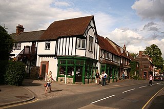
Otford is a village and civil parish in the Sevenoaks District of Kent, England. It lies on the River Darent, 3 miles (5 km) north of Sevenoaks. Otford's four churches are the Anglican Church of St Bartholomew in the village centre, the Otford Methodist Church, the Most Holy Trinity Roman Catholic Church, and the Otford Evangelical Church. By the village pond, also a roundabout, there are pubs, cafes and shops. The village has three schools, Otford Primary School, St Michael's Prep School, and Russell House.

West Kingsdown is a village and civil parish in the Sevenoaks district of Kent, England, on the A20 5 miles (8 km) southeast of Swanley, 5.5 miles (9 km) northeast of Sevenoaks and 22.5 miles (36.2 km) from London.

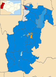
Sevenoaks is a constituency represented in the House of Commons of the UK Parliament since 2019 by Laura Trott, a Conservative.

Brasted is a village and civil parish in the Sevenoaks District of Kent, England. Brasted lies on the A25 road, between Sundridge and Westerham; the road is named Westerham Road, High Street and Main Road as it passes through the village east to west. Brasted is 6 km west of Sevenoaks town. The parish had a population of 1321 and includes the hamlets of Brasted Chart, Toys Hill and Puddledock. The village of Brasted has a number of 18th-century houses with several antique shops, pubs and residences. The parish church is dedicated to St Martin.
Knockholt is a village and civil parish in the Sevenoaks District of Kent, England. It is located 5 mi (8 km) north west of Sevenoaks & 5.7 mi (9.2 km) south of Orpington, adjacent to the Kent border with Greater London.
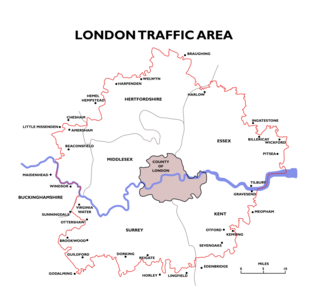
The London Traffic Area was established by the London Traffic Act 1924 to regulate the increasing amount of motor traffic in the London area. The LTA was abolished in 1965 on the establishment of the Greater London Council.
Ruxley is a small settlement in southeast London, England, with no present formal boundaries. It is located 21 km (13 mi) southeast by east of Charing Cross, in the northeast corner of the London Borough of Bromley on the borough boundary with the southeast corner of the London Borough of Bexley, and is also adjacent to the Greater London border with Kent, overlapping into the Sevenoaks District and Borough of Dartford in Kent. Ruxley lies east of Sidcup and west of Swanley, on green belt land, where two main roads pass through east-west connecting London to the coast. Ruxley was a parish prior to 1557 and had its own thirteenth century church, St Botolph's. Ruxley's central location on the main road made it an important meeting place for the Hundred of Ruxley, which was named after it. Today still a major transport route, Ruxley's location on green belt land is on the edge of London's urban sprawl, industrial and residential areas are found on the west side, but to the east this quickly turns into more rural woodland and farmland. Ruxley Gravel Pits is a biological Site of Special Scientific Interest located on the west side of Ruxley. Today the area is known for Ruxley Manor, a large site with a garden centre and other retailers and services.
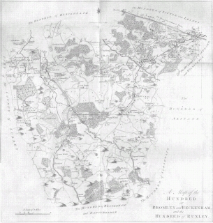
Ruxley was an ancient hundred, a land division in the north west of the county of Kent, England. Its area has been mostly absorbed by the growth of London; with its name currently referring to the Ruxley district. Its former area now corresponds to a majority of the London Borough of Bromley, a large part of the London Borough of Bexley and a small part of the Kent District of Sevenoaks. The hundred was within the Lathe of Sutton-at-Hone, in the west division of Kent.

Sutton-at-Hone is a village in the civil parish of Sutton-at-Hone and Hawley in the Borough of Dartford in Kent, England. It is located 3.5 miles south of Dartford & 3.6 miles north east of Swanley.

The waymarked path Darent Valley Path is 19 miles (31 km) long, following the River Darent from the banks of the River Thames at Dartford through the Kent Downs Area of Outstanding Natural Beauty to the Greensand Hills above Sevenoaks. It runs through the villages of Shoreham and Otford.
Sevenoaks Rural District was a rural district in the county of Kent, England, from 1894 to 1974. It did not include Sevenoaks Urban District, which covered the town of Sevenoaks. It was created in 1894 from the majority of the area of Somerden Hundred, and parts of the Hundreds of Codsheath, Brasted, and Westerham and Edinbridge.

Axstane was a hundred in the county of Kent, England. The Hundred of Axstane lay south-east of Dartford and Wilmington Hundred. It is called Achestan in Domesday Book, but by the reign of Edward I it was called Axstane.
The Latheof Sutton-at-Hone historically included a large part of Kent: the present-day boroughs of Dartford, Bexley, Greenwich, Bromley, Lewisham, Sevenoaks District and small parts of the Borough of Tonbridge and Malling and Borough of Tunbridge Wells.

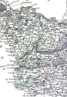
Somerden was a hundred, a historical land division, in the county of Kent, England. It occupied the southwest corner of Kent, in the southern part of the Lathe of Sutton-at-Hone, within in the west division of Kent. The hundred was one of the last to be created in Kent, unlike the majority of Kent hundreds, it was not formally constituted in the Domesday Book of 1086, but came into being sometime after. Today the area is mostly rural and located in the southern part of the Sevenoaks District, south of Sevenoaks and west of Tonbridge. Somerden Hundred was approximately 7.5 mi (12.1 km) wide east to west, and 5.5 mi (8.9 km) long north to south, and had a small exclave about 1 mi (1.6 km) out from its south east corner. In the 1831 census Somerden was recorded as having an area of 13,650 acres (55 km2). The population in that census was recorded as 3,924, of which 2,078 were male and 1,846 were female, who belonged to 734 families living in 567 houses.

Little and Lesnes was a hundred, a historical land division, in the county of Kent, England. It occupied the northern part of the Lathe of Sutton-at-Hone, within in the west division of Kent. Little and Lesnes was the northernmost hundred in the whole county of Kent. The hundred existed since ancient times, before the Domesday Book of 1086, until it was made obsolete with the creation of new districts at the end of the nineteenth century.
The 2019 Sevenoaks District Council election took place on 2 May 2019 to elect members of Sevenoaks District Council. This was on the same day as other local elections. The entire council was up for election. The result was a reduced majority for the Conservatives but was still a large victory. Independents made gains, as did the Liberal Democrats. UKIP lost the 1 seat they had won in 2015. No contest was held in 4 wards, as the same number of candidates as seats up for election ran.

St Botolph's Church is a church building in Ruxley, in the London Borough of Bromley, southest London, England. It was constructed in the thirteenth century and dedicted to Botwulf of Thorney. St Botolph's was used as a church for around 300 years but was deconsecrated in 1557. The church was then used a farm building for over 400 years and the remains of an oast house are still adjacent to it. In the 1960s archaeological work was carried out on the site and found evidence of an older wooden building, suggesting there may have been an older Saxon church in the same location. Today the church is a Grade II listed building and a scheduled ancient monument on the grounds of Ruxley Manor Garden Centre, although many features are still intact, the church is in disrepair and English Heritage have agreed to pay a grant to help preserve the building.

