The lathe was an ancient administrative division of Kent and originated, probably in the 6th century AD, during the Jutish colonisation of the county.[1] It was not unusual for the Anglo-Saxons to establish their juridical and administrative centres a short distance from more populous towns. In this case Sutton at Hone is about two miles from Dartford, one of only four royal manors in Kent at the time of the Domesday Book.[2]
At that time, Sutton was ranked as a "Half Lathe", as was Milton, to which it was not connected. Alongside these two Half Lathes were five (full) Lathes: Aylesford, Borough, Eastry, Lympne (later renamed Shepway) and Wye. By 1295 Sutton had been promoted to a full lathe, while alongside it were only four other lathes. This was because Borough and Eastry had merged into the Lathe of Saint Augustine, while Milton and Wye had merged to form the Lathe of Scray.[3]
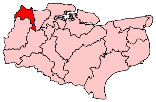
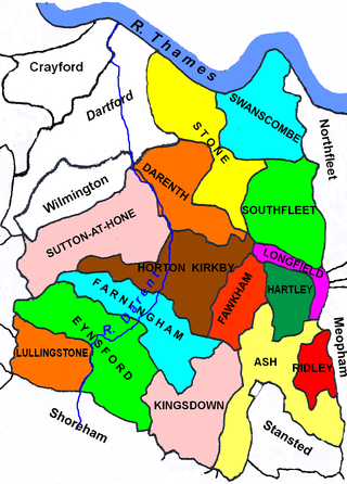
Lathe of Sutton at Hone
The Lathe continued to be an important administrative, judicial and taxation unit for 600 years after the Domesday Book. The functions of Lathe and hundreds were somewhat similar, with a Lathe covering a much wider area. Although never formally abolished, it has had no administrative functions since the end of the 19th century.[4] The Sheriff toured the county twice yearly, visiting each lathe: in the case of Sutton, possibly at Shire Hall. The lathe was responsible for raising of aids and subsidies for the Militia. However the Lathe court became anomalous as it fell between the hundred courts below and the Justices of the County (in petty and quarter sessions) above [5]
The lathe was the most westerly of the lathes into which Kent was divided. The first four hundreds in the above list now collectively form the London boroughs of Lewisham, Greenwich, Bexley and Bromley except Penge which was not originally in the county of Kent.
Dartford and Wilmington Hundred is now in the borough of Dartford. Axstane hundred is now divided between the districts of Dartford and Sevenoaks, while the last three hundreds form the remainder of Sevenoaks District, except that Somerden and therefore the Lathe of Sutton included part of the parish of Speldhurst, which is now in Royal Tunbridge Wells. Thus the boundary of the Lathe with the rest of Kent is still in existence, with minor deviations, as the boundaries Dartford and Sevenoaks local authorities have with the rest of Kent.[8]
The Lathe of Sutton had an area of 173,440 acres (271 sq. miles or 702 km2).[9]
Notes
↑ Dartford Country - The Story Of The Hundred Of Axstane by Geoff Porteus, 1985, ISBN9780860232032 (page 13)
↑ Dartford Country - The Story Of The Hundred Of Axstane by G. Porteus (page 22)
↑ Dartford Country - The Story Of The Hundred Of Axstane by G. Porteus (page 32)
↑ "The said railway deviation being wholly within the parish of Stone, in the county of Kent, Hundred of Axton, Lathe of Sutton-at-Hone" - THE LONDON GAZETTE, MAY 30, 1899
↑ See The History and Topographical Survey of the County of Kent: Volume 1, author:Edward Hasted, publ. 1797
↑ See the list of parishes for each hundred in the History and Topographical Survey of the County of Kent: (Vols 1 and 2), author:Edward Hasted, publ. 1797. Also the census report by lathe and hundred in Victoria County History of Kent, Vol 3 (1932)
↑ The Hidation of Kent by J. E. A. Jolliffe and Census 1832
Related Research Articles
A lathe formed an administrative country subdivision of the county of Kent, England, from the Anglo-Saxon period, until it fell out of general practical use in the early twentieth century.
Kent is a traditional county in South East England with long-established human occupation.
Dartford is a constituency in Kent represented in the House of Commons of the UK Parliament since 2010 by Gareth Johnson of the Conservative Party. It is the constituency that, in the entire UK, has longest been a bellwether: the party of the winning candidate has gone on to form the government at every UK general election since 1964. Candidates for the largest two parties nationally have polled first and second since 1923 in Dartford.
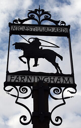
Farningham is a village and civil parish in the Sevenoaks District of Kent, England. It is located 3 miles (5 km) south-east of Swanley. It has a population of 1,314.
The London Traffic Area was established by the London Traffic Act 1924 to regulate the increasing amount of motor traffic in the London area. The LTA was abolished in 1965 on the establishment of the Greater London Council.
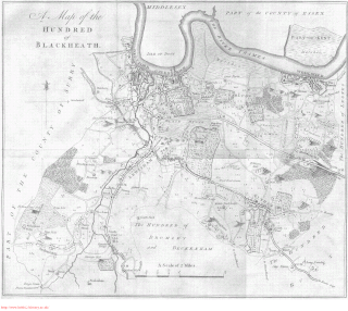
Blackheath was an ancient hundred in the north west of the county of Kent in England. It had become obsolete by the beginning of the 20th century in the wake of ongoing reforms to local government. The name "Blackheath" now refers to a district of SE London. In 2022, the area of the old hundred lies mainly within the Royal Borough of Greenwich.
Ruxley is a rural settlement of South East London, England that straddles the boundary of the London Boroughs of Bromley and Bexley. It is located 13 miles southeast of Charing Cross, the traditional centre of London, in the Metropolitan Green Belt between Sidcup and Swanley and is also adjacent to the Greater London border with the county of Kent.
Ruxley was an ancient hundred, a land division in the north west of the county of Kent, England. Its area has been mostly absorbed by the growth of London; with its name currently referring to the Ruxley district. Its former area now corresponds to a majority of the London Borough of Bromley, a large part of the London Borough of Bexley and a small part of the Kent District of Sevenoaks. The hundred was within the Lathe of Sutton-at-Hone, in the west division of Kent.
Sutton-at-Hone is a village in the civil parish of Sutton-at-Hone and Hawley in the Borough of Dartford in Kent, England. It is located 3.5 miles south of Dartford & 3.6 miles north east of Swanley.
North Cray is an area in South East London, England, within the London Borough of Bexley. It is located east of Sidcup and south of Bexleyheath and is 12.6 miles (20.3 km) south-east of Charing Cross, the traditional centre of London in the Metropolitan Green Belt.
Ridley is a place and former civil parish, now in the parish of Ash-cum-Ridley, in the Sevenoaks district, in the county of Kent, England. It lies between Sevenoaks and Chatham..
Axstane was a hundred in the county of Kent, England. The Hundred of Axstane lay south-east of Dartford and Wilmington Hundred. It is called Achestan in Domesday Book, but by the reign of Edward I it was called Axstane.
The Lathe of Scray is an historic division of the county of Kent, England, encompassing the present-day Districts of Swale, Ashford, and the eastern part of Tunbridge Wells The Lathes of Kent were ancient administration divisions originating, probably, in the 6th century, during the Jutish colonisation of the county.
The Latheof St Augustine is an historic division of the county of Kent, England, encompassing the present-day Districts of Canterbury, Dover and Thanet. The Lathes of Kent were ancient administration divisions originating, probably, in the 6th century, during the Jutish colonisation of the county.
Somerden was a hundred, a historical land division, in the county of Kent, England. It occupied the southwest corner of Kent, in the southern part of the Lathe of Sutton-at-Hone, in the west division of Kent. The hundred was one of the last to be created in Kent, unlike the majority of Kent hundreds, it was not formally constituted in the Domesday Book of 1086, but came into being sometime after. Today the area is mostly rural and located in the southern part of the Sevenoaks District, south of Sevenoaks and west of Tonbridge. Somerden Hundred was approximately 7.5 mi (12.1 km) wide east to west, and 5.5 mi (8.9 km) long north to south, and had a small exclave about 1 mi (1.6 km) out from its south east corner. In the 1831 census Somerden was recorded as having an area of 13,650 acres (55 km2). The population in that census was recorded as 3,924, of which 2,078 were male and 1,846 were female, who belonged to 734 families living in 567 houses.
Codsheath was a hundred, a historical land division, in the county of Kent, England. It occupied the eastern part of the Lathe of Sutton-at-Hone, in the west division of Kent. Codsheath was also recorded as "Codsede" in ancient records. Today the area that was the Codsheath Hundred is part of the Sevenoaks District of Kent that includes the town of Sevenoaks and surrounding area. The Hundred of Codsheath was included in the Domesday Book of 1086, that records it as having 203 houses, 44 in Sundridge and 159 in Otford. The River Darent flowed through the Codsheath Hundred, generally in a northeast direction. Several watermills were constructed on the river within the hundred, in the villages of Sundridge, Otford, Shoreham and Chevening.
Little and Lesnes was a hundred, a historical land division, in the county of Kent, England. It occupied the northern part of the Lathe of Sutton-at-Hone, within in the west division of Kent. Little and Lesnes was the northernmost hundred in the whole county of Kent. The hundred existed since ancient times, before the Domesday Book of 1086, until it was made obsolete with the creation of new districts at the end of the nineteenth century.
St Botolph's Church is a church building in Ruxley, in the London Borough of Bromley, southeast London, England. It was constructed in the thirteenth century and dedicted to Botwulf of Thorney. St Botolph's was used as a church for around 300 years but was deconsecrated in 1557. The church was then used a farm building for over 400 years and the remains of an oast house are still adjacent to it. In the 1960s archaeological work was carried out on the site and found evidence of an older wooden building, suggesting there may have been an older Saxon church in the same location. Today the church is a Grade II listed building and a scheduled ancient monument on the grounds of Ruxley Manor Garden Centre, although many features are still intact, the church is in disrepair and English Heritage have agreed to pay a grant to help preserve the building.
This page is based on this Wikipedia article Text is available under the CC BY-SA 4.0 license; additional terms may apply. Images, videos and audio are available under their respective licenses.