The Pennine Alps, also known as the Valais Alps, are a mountain range in the western part of the Alps. They are located in Switzerland (Valais) and Italy.

The canton of Valais is one of the 26 cantons of Switzerland, situated in the southwestern part of the country, around the valley of the Rhône from its headwaters to Lake Geneva, separating the Pennine Alps from the Bernese Alps. The canton is simultaneously one of the driest regions of Switzerland in its central Rhône valley and among the wettest, having large amounts of snow and rain up on the highest peaks found in Switzerland. The canton of Valais is widely known for the Matterhorn and resort towns such as Crans-Montana, Saas Fee, Verbier and Zermatt. It is composed of 13 districts and its capital is Sion.

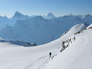
The Haute Route, is the name given to a route undertaken on foot or by ski touring between Chamonix in France and Zermatt in Switzerland.

The Susa Valley is a valley in the Metropolitan City of Turin, Piedmont region of northern Italy, located between the Graian Alps in the north and the Cottian Alps in the south. It is the longest valley in Italy. It extends over 50 km (31 mi) in an east-west direction from the French border to the outskirts of Turin. The valley takes its name from the city of Susa which lies in the valley. The Dora Riparia river, a tributary of the Po, flows through the valley.

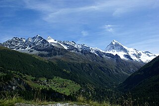
Arolla is a village in the municipality of Evolène in the canton of Valais in Switzerland.

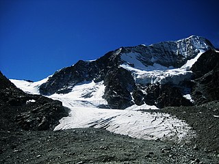
Mont Blanc de Cheilon is a mountain of the Pennine Alps, located in the Swiss canton of Valais. The mountain lies between the valleys of Bagnes and Arolla. Culminating at 3,870 metres above sea level, it is one of the highest summits between the Grand Combin to the west and the Dent Blanche to the east. The massif is glaciated, with the Cheilon Glacier to the north, the Giétro Glacier to the west, the Brenay Glacier to the south and the Tsijiore Nouve Glacier to the east.

The Aiguilles Rouges d'Arolla are a multi-summited mountain of the Swiss Pennine Alps, located west of Arolla in the canton of Valais. The main summit has an elevation of 3,646 metres above sea level.

The Aiguille de la Tsa is a mountain of the Swiss Pennine Alps, overlooking Arolla in the canton of Valais. It lies on the range culminating at the Dent de Perroc, between the valley of Arolla and the Mont Miné Glacier.

The Dent de Perroc is a mountain of the Swiss Pennine Alps, overlooking Arolla in the canton of Valais. With an elevation of 3,676 metres above sea level, the Dent de Perroc is one of the highest summit of the range separating the valley of Arolla on the west side from the valley of the Mont Miné Glacier on the east side.
The Pointe de Vouasson is a mountain of the Swiss Pennine Alps, overlooking Lac des Dix in the canton of Valais. It lies between the valleys of Hérémence (west) and Arolla (east), north of the Aiguilles Rouges d'Arolla.

La Cassorte is a mountain of the Swiss Pennine Alps, located west of Arolla in the canton of Valais. It lies on the range between the Lac des Dix and the Val d'Arolla, south of the Aiguilles Rouges d'Arolla.

L'Evêque is a mountain of the Pennine Alps, overlooking the Col Collon in the canton of Valais, south of Mont Collon. With a height of 3,716 meters above sea level, it is one of the highest summits in the Arolla valley.
The Pointe de Bertol is a mountain of the Swiss Pennine Alps, located south of Arolla in the canton of Valais. On its southern side it overlooks the Bertol Pass.
The Pointe des Genevois is a mountain of the Swiss Pennine Alps, overlooking Arolla in the canton of Valais. It lies just south of the higher summit of the Dent de Perroc.

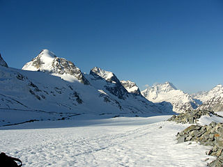
The Arolla Glacier is a 4 km (2.5 mi) long glacier (2005) situated in the Pennine Alps in the canton of Valais in Switzerland. In 1973 it had an area of 13.17 km2 (5.08 sq mi).

The Vignettes Hut is an alpine hut, located south of Arolla in the Swiss canton of Valais. It lies at a height of 3,160 metres above sea level, at the foot of the Pigne d'Arolla and near the Col de Chermotane in the Pennine Alps. All accesses to the hut involve glacier crossing.

Col Collon is a high mountain pass across the central Pennine Alps, connecting Arolla in the Swiss canton of Valais to Bionaz in the Italian region of Aosta Valley.

La Serpentine is a mountain of the Swiss Pennine Alps, located south of Arolla in the canton of Valais. It lies west of the Pigne d'Arolla, on the range between the valley of Bagnes and the valley of Arolla.

The Dix Hut is a mountain hut of the Swiss Alpine Club, located south of Hérémence in the canton of Valais. The hut lies above the Cheilon Glacier, at a height of 2,928 metres above sea level, approximately halfway between the Lac des Dix and the Mont Blanc de Cheilon.