
Ulster County is a county in the U.S. state of New York. It is situated along the Hudson River. As of the 2020 census, the population was 181,851. The county seat is Kingston. The county is named after the Irish province of Ulster. The county is part of the Hudson Valley region of the state.

Olive is a town in Ulster County, New York, United States. The town is west of Kingston, New York, and is inside the Catskill Park. The population was 4,226 at the 2020 census.
The Ulster and Delaware Railroad (U&D) was a railroad located in the state of New York. It was often advertised as "The Only All-Rail Route to the Catskill Mountains." At its greatest extent, the U&D extended 107 miles (172 km) from Kingston Point on the Hudson River through the Catskill Mountains to its western terminus at Oneonta, passing through the counties of Ulster, Delaware, Schoharie and Otsego.

West Hurley, MP 9.8, later MP 10.2, was a railroad station on the Ulster and Delaware Railroad in West Hurley, New York that was constructed in the late nineteenth century and rebuilt during the construction of the Ashokan Reservoir. The original station was made of wood. It was later torn down and temporarily replaced with a board-and-batten shed close to Woodstock, which created much local indignation. A new brick station to replace it was constructed at the West Hurley Dike of the Ashokan Reservoir. The depot was torn down in 1967.

Boiceville Railroad Station was built by the Ulster and Delaware Railroad to serve the community of Boiceville, New York. Located at MP 21.3, Boiceville was the westernmost depot to be removed as a result of the construction of the Ashokan Reservoir. Although the community of Boiceville was submerged, the station site remains above the reservoir level, at a point just west of where the old railroad right of way slips under the waters of the reservoir, and just east of where it diverges from the new line.

New York State Route 214 (NY 214) is a 12.48-mile (20.08 km) long state highway through the Catskill Park sections of Ulster and Greene counties. The route begins at an intersection with NY 28 in the town of Shandaken, just southwest of the hamlet of Phoenicia. The route runs through the narrow mountain pass called Stony Clove Notch before reaching the town of Hunter, where it ends at NY 23A.

The Ashokan Reservoir is a reservoir in Ulster County, New York. It is at the eastern end of the Catskill Park, and is one of several in the region created to provide the City of New York with water. It is the city's deepest reservoir at 190 feet (58 m) near the dam at the former site of Bishop Falls.

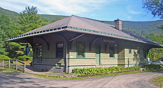
Ashokan was a former railroad station located in the Shokan section of the town of Olive, Ulster County, New York, United States. Located 16.2 miles (26.1 km) from the terminus at Kingston Point in Kingston, it was located along the Ulster and Delaware Railroad, later the Catskill Mountain Branch of the New York Central Railroad. The station opened on June 8, 1913, when the railroad abandoned their former alignment due to the construction of the Ashokan Reservoir. The railroad moved the station depot at Brown's Station to Ashokan for service.
The Catskill Mountain Railroad is a heritage tourist railroad based in Kingston, New York, that began operations in 1982. The railroad leases a 4.7-mile portion of the former New York Central Railroad Catskill Mountain branch from Kingston to Stony Hollow, New York. The tracks are owned by Ulster County, New York, which bought them in 1979 from the bankruptcy estate of the Penn Central Railroad. The railroad's current permit with Ulster County expires on December 31, 2028.
Phoenicia station is a repurposed train station located on High Street just south of Phoenicia, New York, United States. It is a frame building that opened in 1899.
Pine Hill station, MP 39.7 on the Ulster and Delaware Railroad (U&D), served the village of Pine Hill, New York. It was constructed on the slope of Belle Ayr Mountain 100 feet above the village along the steep grade running from Big Indian to the summit at Grand Hotel station. The famous double horseshoe curves on the U&D were located just west of the station.

The Wallkill Valley Railroad is a defunct railroad which once operated in Ulster and Orange counties in upstate New York. Its corridor was from Kingston in the north to Montgomery in the south, with a leased extension to Campbell Hall. It crossed both the Wallkill River and Rondout Creek.

Halcottville station, MP 53.0 on the Ulster and Delaware Railroad (U&D), served the hamlet of Halcottville. On February 1, 1932, the U&D became the Catskill Mountain Branch of the New York Central Railroad. In addition to the station, the U&D constructed a large ice-house here and stored ice from Lake Wawaka. A tiny steamboat, also named Wawaka, plied the lake during the summer months drawing visitors from up and down the line who rode the boat and picnicked on the shores of Lake Wawaka. Halcottville boasted a hotel, two creameries, an early electric light plant, several stores, a post office, dance hall, school, and several churches. There were also numerous boarding houses in the area.
Roxbury station is a disused train station on the former Ulster and Delaware Railroad / West Shore "Catskill Mountain Branch" in the hamlet of Roxbury, New York. The station is a contributing property to the Ulster and Delaware Railroad Depot and Mill Complex, a historic district on the National Register of Historic Places.

Haines Falls is an abandoned train station in Haines Falls, New York. It was owned by the Ulster and Delaware Railroad. The abandoned station was restored in 1999 and is one of two surviving U&D branch stations. It is now the headquarters of the Mountain Top Historical Society. It is also the start of the Kaaterskill Rail Trail, a scenic hiking trail along the former railway.
Kaaterskill station, branch MP 19.1, was one of the busiest railroad stations on the branch lines of the Ulster and Delaware Railroad (U&D). It was near the banks of South Lake in Kaaterskill, New York, and was a major stop for people who wished to stay at the Hotel Kaaterskill or the Catskill Mountain House, which was 0.93 miles from the station.
Ashokan High Point or High Point is a 3,081 feet (939 m) summit in the Catskill Mountains of New York. High Point is the loftiest part of a massif that includes the adjacent Mombaccus Mountain, Little Rocky and South Mountain. The summit can be accessed via the Kanape Brook Trail, which ascends from Ulster County Road 42 to the saddle between High Point and Mombaccus. This trail, named for 19th-century farmer John Canape, was formerly a wagon track connected to the present-day Freeman Avery Road on the south side of the mountain, providing a route between Watson Hollow and Samsonville in the days of the Catskills tanneries. The Gazetteer and Business Directory of Ulster County, N. Y. For 1871-2 referred to the peak as "Shokan Point". It was also known as "Samson," after the Catskill tannery owner for whom Samsonville was named, and is so identified on a 1942 United States Coast and Geodetic Survey benchmark at the summit. Nowadays, Samson Mountain is the name given to a nearby peak above the upper reaches of Rondout Creek.
Michael P. Hein is an American politician who served as the 1st County Executive of Ulster County, serving until February 10, 2019 after having first been elected on November 4, 2008. Prior to the creation of this position, the 2008 ratification by referendum of the Ulster County Charter, he was the Ulster County Administrator.

Samsonville is a hamlet in the southwestern part of the town of Olive in Ulster County, New York, United States. Bordered to the north by Mombaccus Mountain and Ashokan High Point, it is within the Catskill Park on the southeastern slopes of the high Catskills.
