
Halifax is the capital and largest municipality of the Canadian province of Nova Scotia, and the largest municipality in Atlantic Canada. As of 2022, it is estimated that the population of the Halifax CMA was 480,582, with 348,634 people in its urban area. The regional municipality consists of four former municipalities that were amalgamated in 1996: Halifax, Dartmouth, Bedford, and Halifax County.

Eastern Passage is an unincorporated suburban community in Halifax Regional Municipality Nova Scotia, Canada.

Cole Harbour is a former village and current community located in Nova Scotia, Canada that is part of the Halifax Regional Municipality.

The Eastern Shore is a region of the Canadian province of Nova Scotia. It is the Atlantic coast running northeast from Halifax Harbour to the eastern end of the peninsula at the Strait of Canso.
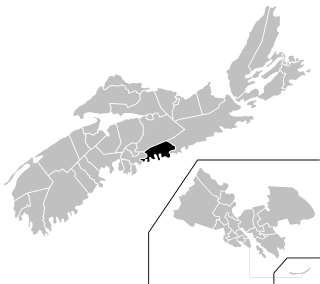
Eastern Shore is a provincial electoral district in Nova Scotia, Canada, that elects one member of the Nova Scotia House of Assembly.
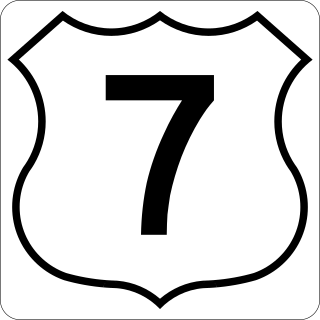
Nova Scotia Trunk 7 is part of the Canadian province of Nova Scotia's system of Trunk Highways. The route runs from Bedford to Antigonish, along the Eastern Shore for a distance of 269 kilometres (167 mi). Part of Trunk 7 is known as the Marine Drive.
Route 322 is a collector road in the Canadian province of Nova Scotia.

Route 207 is a collector road in the Canadian province of Nova Scotia. It is located in the Halifax Regional Municipality and connects Dartmouth to Porters Lake on the Eastern Shore.
The Marine Drive is a designated scenic route along Nova Scotia's Eastern Shore. It closely follows the coast of the Atlantic Ocean and the Strait of Canso from the Canso Causeway to the junction of Route 322 and Highway 111 in Dartmouth.
West Lawrencetown is a residential community within the Halifax Regional Municipality Nova Scotia on the Eastern Shore on Route 207 along the scenic route Marine Drive.
East Lawrencetown is a rural community within Halifax Regional Municipality in Nova Scotia, Canada on the Eastern Shore on Route 207 along the scenic route Marine Drive. The community is 22.4 kilometers from Halifax. Lawrencetown Beach Provincial Park is located in the community, at the southern end of Lawrencetown Lake, a natural ocean inlet. The beach is a year-round destination for surfing, attracting both locals and those from abroad. There are also places to park vehicles, stroll along boardwalks, hike, mountain bike and swim. Available to the public in the summer is a canteen, showers, flush toilets and a section of beach that is supervised by the Nova Scotia Lifeguard Service.
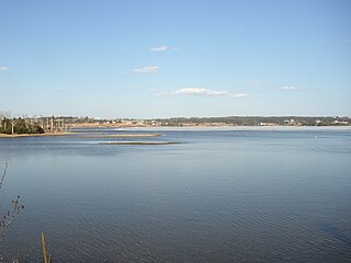
Porters Lake is a rural community in the Eastern Shore region of the Halifax, Nova Scotia, Canada, between Trunk 7 and Route 207, 27.8 km from Halifax. The residents mainly commute to jobs in Dartmouth, Burnside Industrial Park or in Downtown Halifax. The community is built around the lake from which it takes its name.

Halifax Regional Municipality has a multi-modal transportation network.

Nova Scotia is a province located in Eastern Canada fronting the Atlantic Ocean. One of the Maritime Provinces, Nova Scotia's geography is complex, despite its relatively small size in comparison to other Canadian provinces.

Lawrencetown is a Canadian rural community in the Halifax Regional Municipality in Nova Scotia, Canada. The settlement was established during the eve of Father Le Loutre's War and at the beginning of the French and Indian War.

Cape Chignecto Provincial Park is a Canadian provincial park located in Nova Scotia. A wilderness park, it derives its name from Cape Chignecto, a prominent headland which divides the Bay of Fundy with Chignecto Bay to the north and the Minas Channel leading to the Minas Basin to the east. The park, which opened in 1998, is the largest provincial park in Nova Scotia. It also anchors one end of the UNESCO Cliffs of Fundy Global Geopark.

The Eastern Shore is a tourism region of the province of Nova Scotia, Canada. It provides two percent of the revenue for the province's tourism economy. One of its key features is an archipelago known as the 100 Wild Islands area.
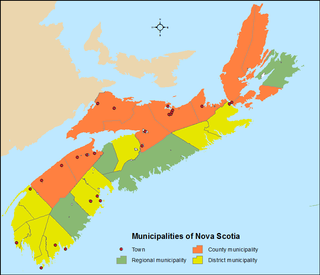
The Canadian province of Nova Scotia is divided into 49 municipalities, of which there are three types: regional (4), town (25), and county or district municipality (20).
