Related Research Articles

Gustavo A. Madero is the northernmost borough of Mexico City.

Gustavo Adolfo Madero González, born in Parras de la Fuente, Coahuila, Mexico, was a participant in the Mexican Revolution against Porfirio Díaz along with other members of his wealthy family. He was also known as "Ojo Parado" since he had one glass eye.
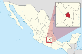
Mexico City is one of the 32 federal entities of Mexico, the others being the 31 states. It was named Distrito Federal up to February 5, 2016, when it was officially renamed the Ciudad de México. According to the 2020 Mexican Census, it is the second most populated entity with 9,209,944 inhabitants and the smallest by land area spanning 1,494.3 square kilometres (577.0 sq mi).

Deportivo 18 de Marzo is a station on the Mexico City Metro. It is located in Mexico City's Gustavo A. Madero borough.

Colonia Villa de Guadalupe is a former separate town, now a neighborhood in northern Mexico City which in 1531 was the site of the apparition of Our Lady of Guadalupe, the most renowned Marian apparition in the Americas. She is venerated in the Our Lady of Guadalupe Shrine, located in the villa (town).
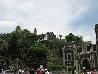
Tepeyac or the Hill of Tepeyac, historically known by the names Tepeyacac and Tepeaquilla, is located inside Gustavo A. Madero, the northernmost delegación or borough of Mexico City. According to the Catholic tradition, it is the site where Saint Juan Diego met the Virgin of Guadalupe in December 1531, and received the iconic image of the Lady of Guadalupe. The Basilica of Our Lady of Guadalupe located there is one of the most visited Catholic shrines in the world. Spanish colonists erected a Catholic chapel at the site, Our Lady of Guadalupe, "the place of many miracles." It forms part of the Sierra de Guadalupe mountain range.

Lindavista is a metro station along Line 6 of the Mexico City Metro. It is located in the Gustavo A. Madero borough. In 2019, the station had an average ridership of 17,878 passengers per day.

The Eje Central or Avenida Lázaro Cárdenas is an avenue in the Cuauhtémoc and Gustavo A. Madero boroughs of Mexico City, Mexico. It is part of a system called eje vial of roadways built by Carlos Hank González to modernize Mexico City for improved traffic flow through the city. As its name indicates, it runs through the central zones of the city, starting at Río de los Remedios Avenue and ending at Río Churubusco Avenue, near Eje Central metro station.

The Convent of San Francisco is located at the western end of Madero Street in the historic center of Mexico City, near the Torre Latinoamericana and is all that remains of the church and monastery complex. This complex was the headquarters of the first twelve Franciscan friars headed by Martín de Valencia who came to Mexico after receiving the first authorization from the Pope to evangelize in New Spain. In the early colonial period, this was one of the largest and most influential monasteries in Mexico City. It was built on the site of where Moctezuma II’s zoo once was. At its peak, the church and monastery covered the blocks now bordered by Bolivar, Madero, Eje Central and Venustiano Carranza Streets, for a total area of 32,224 square metres.

Colegio de San Ignacio de Loyola Vizcaínas is a non-profit educational institution which was established in the mid 18th century in a Baroque building that occupies an entire city block in the historic center of Mexico City. The school has maintained most of its mission and organization and is the only continuously operating colonial era institution in Mexico. It was originally established for the education of orphaned girls and widows, but now it is co-educational. It offers education from kindergarten through senior high school. The building is not generally open to tourists, but can be rented for social events, such as the Shallalom wedding.

Lindavista is a neighbourhood in the north of Mexico City, in the administrative district of Gustavo A. Madero. The streets in Lindavista are named after cities in Latin America.

The Borda House, located on 27, 29 and 33 Madero Street, and 26-28 Bolivar streets in the historic center of Mexico City, originally belonged to the Frenchman José de la Borda who was one of the richest men in New Spain in the 18th century. It stands out due to its notable architectural features such as the sculpted stone decorative details on the ground floor. The original building encompassed the entire city block. It had various inner courtyards, and Borda had an ironwork balcony built all the way around the building, supported by angles in the shape of rooster feet. This allowed one to walk all the way around the building on the outside.

El Tepeyac National Park is one of a number of federally recognized national parks in Mexico that are protected natural areas and administered by the federal National Commission of Protected Natural Areas (CONANP), a subsidiary of SEMARNAT. It is one of the few green areas located north of the Mexico City suburbs. 95% of its territory is located in Gustavo A. Madero, D.F. Borough and 5% in the municipality of Tlalnepantla de Baz.

Ecatepec, officially Ecatepec de Morelos, is a municipality in the central Mexican state of Mexico, and is situated in the north part of the greater Mexico City urban area. The municipal seat is San Cristóbal Ecatepec.

The Colegio Franco Español is a private school in the San Lorenzo Huipulco colonia in Tlalpan, Mexico City. It covers preschool through high school (preparatoria) levels.

Mixcoac is an area of southern Mexico City which used to be a separate town and municipality within the Mexican Federal District until it was made part of Mexico City proper in 1928.
Sistema Educativo Justo Sierra is a private school and university system in the Mexico City metropolitan area. Universidad Justo Sierra is a part of the system.
Malacates is the northernmost neighborhood of Mexico City in the Gustavo A. Madero borough, built at the foot of the mountains of the Sierra de Guadalupe. The main draw of Malacates is as an entryway to the Sierra de Guadalupe Protected Natural Area. The buildings here are constructed primarily of concrete block, which is typical of emerging neighborhoods.
Verónica Castro is a small neighborhood (colonia) of Mexico City in the Gustavo A. Madero borough.